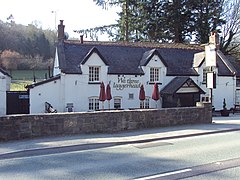
Loggerheads is a village in Denbighshire, Wales on the River Alyn, a tributary of the River Dee.
| Loggerheads | |
|---|---|
 We Three Loggerheads | |
Location within Denbighshire | |
| Population | (2001) |
| OS grid reference | SJ189626 |
| Community | |
| Principal area | |
| Preserved county | |
| Country | Wales |
| Sovereign state | United Kingdom |
| Post town | MOLD |
| Postcode district | CH7 |
| Dialling code | 01352 |
| Police | North Wales |
| Fire | North Wales |
| Ambulance | Welsh |
| UK Parliament | |
| Senedd Cymru – Welsh Parliament | |
It is the location of Loggerheads Country Park which follows the course of the River Alyn through karstic limestone countryside including the sites of old lead mines and mills. There is a working flour mill on site.
A leat or leete, built around 1824, follows the side of the valley nearby and was used to carry water to the lead mines of Mold Mines, on land owned by the Grosvenor family. It is now the popular Leete Walk. The name Loggerheads may come from the dispute over estate boundaries between the lordships of Mold and Llanferres. The final boundary is marked by Carreg Carn March Arthur which is said to bear the imprint of Arthur's horse's hoof after it jumped from the nearby mountain, Moel Famau. The local pub has a sign showing two men grimacing at each other with the words We Three Loggerheads,[1] taken from a painting by Richard Wilson. The third loggerhead was the viewer.
Climate
edit| Climate data for Loggerheads: 210 m (689 ft) 1991–2020 normals, extremes 1960–2020 | |||||||||||||
|---|---|---|---|---|---|---|---|---|---|---|---|---|---|
| Month | Jan | Feb | Mar | Apr | May | Jun | Jul | Aug | Sep | Oct | Nov | Dec | Year |
| Record high °C (°F) | 15.7 (60.3) |
16.7 (62.1) |
22.2 (72.0) |
23.2 (73.8) |
25.0 (77.0) |
29.4 (84.9) |
30.1 (86.2) |
31.7 (89.1) |
27.2 (81.0) |
23.9 (75.0) |
17.6 (63.7) |
14.6 (58.3) |
31.7 (89.1) |
| Mean daily maximum °C (°F) | 6.9 (44.4) |
7.4 (45.3) |
9.4 (48.9) |
11.7 (53.1) |
15.0 (59.0) |
17.2 (63.0) |
19.4 (66.9) |
19.2 (66.6) |
16.3 (61.3) |
12.6 (54.7) |
9.5 (49.1) |
7.1 (44.8) |
12.6 (54.8) |
| Daily mean °C (°F) | 3.8 (38.8) |
4.2 (39.6) |
5.9 (42.6) |
7.5 (45.5) |
10.3 (50.5) |
12.8 (55.0) |
15.0 (59.0) |
14.7 (58.5) |
12.1 (53.8) |
9.0 (48.2) |
6.4 (43.5) |
3.9 (39.0) |
8.8 (47.8) |
| Mean daily minimum °C (°F) | 0.7 (33.3) |
1.0 (33.8) |
2.3 (36.1) |
3.2 (37.8) |
5.6 (42.1) |
8.4 (47.1) |
10.5 (50.9) |
10.2 (50.4) |
8.0 (46.4) |
5.4 (41.7) |
3.3 (37.9) |
0.7 (33.3) |
4.9 (40.9) |
| Record low °C (°F) | −18.3 (−0.9) |
−16.7 (1.9) |
−19.4 (−2.9) |
−11.0 (12.2) |
−4.3 (24.3) |
−2.1 (28.2) |
0.7 (33.3) |
1.1 (34.0) |
−2.0 (28.4) |
−6.2 (20.8) |
−10.9 (12.4) |
−18.7 (−1.7) |
−19.4 (−2.9) |
| Average precipitation mm (inches) | 77.3 (3.04) |
66.0 (2.60) |
57.5 (2.26) |
70.2 (2.76) |
60.2 (2.37) |
66.0 (2.60) |
69.6 (2.74) |
78.9 (3.11) |
91.0 (3.58) |
112.6 (4.43) |
106.9 (4.21) |
98.1 (3.86) |
954.3 (37.56) |
| Average precipitation days | 13.5 | 13.4 | 11.9 | 13.1 | 10.0 | 11.5 | 10.9 | 11.1 | 12.3 | 15.5 | 16.2 | 15.2 | 154.6 |
| Source 1: Météo Climat[2] | |||||||||||||
| Source 2: Météo Climat[3] | |||||||||||||
Further reading
edit- C J Williams, Lead Mines of the Alyn Valley (1987) ISBN 0-9512776-0-X
References
edit- ^ "We Three Loggerheads homepage (slideshow includes an external shot)". 23 December 2010.
- ^ "United Kingdom climate normals 1991-2020". Météo Climat. Retrieved 21 May 2024.
- ^ "Weather Extremes for Loggerheads". Météo Climat. Retrieved 21 May 2024.
External links
edit
