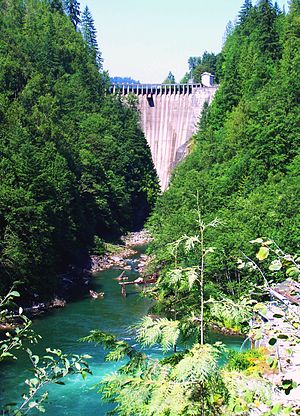
Lower Baker Dam (or simply Baker Dam) is a dam across the Baker River one mile north of Concrete, Washington. It forms a reservoir called Lake Shannon which stretches 7.5 miles (12.1 km) upstream. The dam is operated by Puget Sound Energy as part of the Baker River Hydroelectric Project.[3]
| Lower Baker Dam | |
|---|---|
 Lower Baker Dam from downstream | |
| Country | United States |
| Location | Skagit County, Washington |
| Coordinates | 48°32′51″N 121°44′28″W / 48.54750°N 121.74111°W |
| Status | In use |
| Opening date | 1925 |
| Owner(s) | Puget Sound Energy |
| Dam and spillways | |
| Type of dam | Concrete thick-arch |
| Impounds | Baker River |
| Height | 285 feet (87 m) |
| Length | 550 feet (170 m) |
| Spillway type | Uncontrolled overflow |
| Reservoir | |
| Creates | Lake Shannon |
| Total capacity | 161,470 acre-feet (199,170,000 m3)[1] |
| Catchment area | 250 square miles (650 km2) |
| Surface area | 2,190 acres (890 ha) |
| Power Station | |
| Hydraulic head | 280 feet (85 m) |
| Installed capacity | 79 MW |
| Annual generation | 344,850,000 KWh[2] |
The dam has a thick arch design, and is 285 feet (87 m) high and 550 feet (170 m) long. It spans the Baker River in a narrow reach known as Eden Canyon, just above the river's confluence with the Skagit River. It is able to hold 161,470 acre-feet (199,170,000 m3) of water, of which 29,426 acre-feet (36,296,000 m3) is reserved for flood control. At full capacity the dam's hydroelectric plant can generate 79 megawatts of power.[4] The other dam on this river, Upper Baker Dam, lies about 8 miles (13 km) upstream, and serves a similar purpose to Lower Baker.
References
edit- ^ "SKAGIT RIVER BASIN 112193000 LAKE SHANNON AT CONCRETE, WA" (PDF). wa.water.usgs.gov. Retrieved 18 March 2016.
- ^ "LOWER BAKER". carma.org. Retrieved 18 March 2016.
- ^ "3.3 Water Quantity" (PDF). Baker River Project, FERC No. 2150. Puget Sound Energy. March 2002. Retrieved 2011-01-17.[permanent dead link]
- ^ "Fact Sheet" (PDF). Archived from the original (PDF) on 2013-08-23. Retrieved 2013-07-28."Baker River Hydroelectric Project Fact Sheet" (PDF). Archived from the original (PDF) on 2011-11-06.