This article needs additional citations for verification. (February 2017) |
Federal Route 70, or Jalan Kampar-Changkat Jong, is a federal road in Perak, Malaysia. The road connects Kampar in the north to Changkat Jong in the south.[1]
| Federal Route 70 | |
|---|---|
| Jalan Kampar-Changkat Jong | |
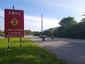
 Route 70 near Mambang Di Awan. | |
| Route information | |
| Length | 36.69 km (22.80 mi) |
| Major junctions | |
| North end | Kampar |
| South end | Changkat Jong |
| Location | |
| Country | Malaysia |
| Primary destinations | Mambang Di Awan Ayer Kuning Degong Chikus Tapah Langkap Teluk Intan |
| Highway system | |

Route background
editThe Kilometre Zero of the Federal Route 70 starts at Kampar, at its interchange with the Federal Route 1, the main trunk road of the central of Peninsular Malaysia.
Features
editAt most sections, the Federal Route 70 was built under the JKR R5 road standard, with a speed limit of 90 km/h.
List of junctions and town
editThis article contains a bulleted list or table of intersections which should be presented in a properly formatted junction table. (November 2021) |
| Km | Exit | Interchange | To | Remarks | |
|---|---|---|---|---|---|
| FT 70 0 |
Kampar | North FT 1 Gopeng FT 1 Ipoh North–South Expressway Northern Route AH2 North–South Expressway Northern Route Bukit Kayu Hitam Penang Ipoh Kuala Lumpur Southeast FT 1 Temoh FT 1 Tapah |
T-junctions | ||
| Railway crossing bridge | |||||
| Kampung Talam | West A180 Jalan Ayer Hitam Labu Tanjung Tualang |
T-junctions | |||
| Mambang Di Awan | |||||
| Kampar-Batang Padang district border | |||||
| Sungai Lesong | East A116 Jalan Temoh Temoh Station Temoh |
T-junctions | |||
| Sungai Lesong | |||||
| Sungai Chenderiang bridge | |||||
| Ayer Kuning | East A120 Jalan Banir Banir |
T-junctions | |||
| Batang Padang-Hilir Perak district border | |||||
| Sungai Batang Padang bridge | |||||
| Kampung Changkat Petai | East A10 Jalan Tapah A10 Tapah Road A10 Tapah FT 59 Cameron Highlands North–South Expressway Northern Route AH2 North–South Expressway Northern Route Bukit Kayu Hitam Penang Ipoh Kuala Lumpur |
Junctions | |||
| Kampung Changkat Petai | West A16 Jalan Labu Kubong A122 Chikus A122 Teluk Intan FT 109 Pasir Salak FT 109 Bota |
T-junctions | |||
| Sungai Chikus bridge | |||||
| Degong | |||||
| Railway crossing | |||||
| Langkap | Southeast A129 Jalan Chui Chak Chui Chak Bidor |
T-junctions | |||
| Jalan Chikus-Langkap | Northwest A149 Jalan Chikus-Langkap Chikus |
T-junctions | |||
| Sungai Pahlawan bridge | |||||
| Sungai Bidor bridge | |||||
| Changkat Jong | West FT 58 Teluk Intan FT 58 Batak Rabit East FT 58 Bidor North–South Expressway Northern Route AH2 North–South Expressway Northern Route Bukit Kayu Hitam Penang Ipoh Kuala Lumpur |
T-junctions | |||
References
edit- ^ Statistik Jalan (Edisi 2013). Kuala Lumpur: Malaysian Public Works Department. 2013. pp. 16–64. ISSN 1985-9619.
