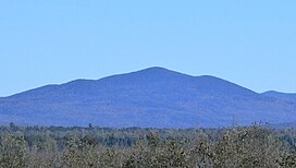
Merrill Mountain (French: Montagne Merrill) is a mountain on the border between the Canadian province of Quebec, in the region of Estrie, and the U.S. state of Maine, which is part of the Appalachian Mountains; its altitude is 997 m (3,271 ft).[1]
| Merrill Mountain | |
|---|---|
 View of Merrill Mountain from Chemin de la Rivière-Bergeron, at Piopolis, Quebec, to the west | |
| Highest point | |
| Elevation | 997 m (3,271 ft) |
| Parent peak | White Mountains (Appalachian Mountains) |
| Coordinates | 45°28′27″N 70°41′32″W / 45.47417°N 70.69222°W |
| Geography | |
 | |
| Location | Estrie Franklin County |
| Countries | Canada United States |
| Province U.S. state | Québec Maine |
| Region(s) | Region County |
Geography
editThe mountain, located in the municipality of Frontenac, on the zec Louise-Gosford east of lac aux Araignées, is crossed by the Canada–United States border.[2]
Toponymy
editThe toponym "Montagne Merrill" was formalized on November 7, 1985, by the Commission de toponymie du Québec.[3]
See also
editReferences
edit- ^ Montagne Merrill, Commission de toponymie du Québec
- ^ "Atlas of Canada from the Department of Natural Resources Canada – Characteristics extracted from the geographic map, database and site instrumentation". 12 September 2016. Retrieved 2021-01-06.
- ^ "Descriptive file: Montagne Merrill". www.toponymie.gouv.qc.ca. Retrieved 2021-01-06.