Module talk:Location map/data/Poland
| This module does not require a rating on Wikipedia's content assessment scale. It is of interest to the following WikiProjects: | ||||||||
| ||||||||
| Revision history for the template that was converted to Module:Location map/data/Poland can be found at Module talk:Location map/data/Poland/attribution: Revision history. |
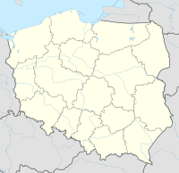
{{Location map
 |Poland
 |label=Warsaw
 |lat_deg=52|lat_min=14
 |lon_deg=21|lon_min=00
 |position=center
 |width=200
 |float=right
}}
Please, add interwikis
edit{{editprotected}}
- be:Шаблон:На карце/Польшча
- el:Πρότυπο:Location map Πολωνία
- hsb:Předłoha:LocMap Pólska
- la:Formula:Charta locatrix Poloniae
- ja:Template:Location map Poland
- nn:Mal:Kartposisjon Polen
- crh:Şablon:Location map Lehistan
- fi:Malline:Location map Poland
- uk:Шаблон:Карта розташування Польща
- zh:Template:Location map Poland --Obersachse (talk) 11:35, 3 January 2009 (UTC)
- Done. Rjd0060 (talk) 22:56, 4 January 2009 (UTC)
{{editprotected}}
- Please add one more be-x-old:Шаблён:Лякалізацыйная мапа Польшчы --Vera.tetrix (talk) 13:30, 15 January 2010 (UTC)
- Done - Rjd0060 (talk) 18:03, 16 January 2010 (UTC)
Wrong interwiki be-x-old:Шаблён:Лякалізацыйная мапа Францыі. Must be be-x-old:Шаблён:Лякалізацыйная мапа Польшчы. --Obersachse (talk) 14:30, 17 January 2010 (UTC)
- Fixed! - Rjd0060 (talk) 21:08, 17 January 2010 (UTC)
{{editprotected}}
+ sv:Mall:Kartposition Polen. -- Lavallen (talk) 12:42, 13 November 2010 (UTC)
relief map
edit{{edit protected}}
Please add the relief version of the map. After | image = Poland location map.svg insert | image 1 = Relief Map of Poland.png. --Obersachse (talk) 08:54, 14 November 2010 (UTC)
- Done by TheDJ. — Martin (MSGJ · talk) 13:04, 15 November 2010 (UTC)
- Oh, sorry, my fault. It must be | image1 = (without space between image and 1). Otherwise it won't work. --Obersachse (talk) 17:36, 15 November 2010 (UTC)
- Done — Martin (MSGJ · talk) 18:45, 15 November 2010 (UTC)
- Oh, sorry, my fault. It must be | image1 = (without space between image and 1). Otherwise it won't work. --Obersachse (talk) 17:36, 15 November 2010 (UTC)
Cat
edit{{edit protected}}
Please add [[Category:Poland location map templates| ]] (it needs creating as a subcategory to [[Category:Poland templates]] and [[Category:Location map by country templates]]). I don't want to create it as empty (please note that multiple other cats of this type have only one item). Feel free to ask at WT:POLAND for more info. --Piotr Konieczny aka Prokonsul Piotrus| talk 16:42, 24 January 2011 (UTC)
- What "Polanmdlocation" means? --Obersachse (talk) 06:23, 25 January 2011 (UTC)
- Sorry, type - fixed now. The category would be an equivalent of Category:France location map templates and other similar ones. --Piotr Konieczny aka Prokonsul Piotrus| talk 00:51, 26 January 2011 (UTC)
- This change can be accomplished by editting Template:Location map Poland/doc which is unprotected. — Martin (MSGJ · talk) 12:08, 27 January 2011 (UTC)
- Sorry, type - fixed now. The category would be an equivalent of Category:France location map templates and other similar ones. --Piotr Konieczny aka Prokonsul Piotrus| talk 00:51, 26 January 2011 (UTC)
Template-protected edit request on 4 July 2015
editThis edit request has been answered. Set the |answered= or |ans= parameter to no to reactivate your request. |
Would you please help me introduce a third map as alternative to relief map of Poland. Currently used relief map does not have rivers which could be extremely useful in some cases. I'm not sure I know enough about this syntax to do it myself even if I wanted to. Thanks in advance.
-
Location map, default image
-
Location map, relief map image1
-
Proposed second relief map image2 (with rivers)
Poeticbent talk 04:33, 4 July 2015 (UTC)
- Done Jackmcbarn (talk) 04:38, 4 July 2015 (UTC)
- Why not simply replace the old raster relief map? Alakzi (talk) 04:41, 4 July 2015 (UTC)
- @Alakzi: If you think the new one is superior, go for it. Jackmcbarn (talk) 04:43, 4 July 2015 (UTC)
- Thanks for doing this. The svg relief map is a perfect supplement to the original default svg location map image. Two svgs are better than one as they say. Poeticbent talk 05:36, 4 July 2015 (UTC)
- @Alakzi: If you think the new one is superior, go for it. Jackmcbarn (talk) 04:43, 4 July 2015 (UTC)
- Why not simply replace the old raster relief map? Alakzi (talk) 04:41, 4 July 2015 (UTC)
- Would you please tell me how to use this brand new option in an infobox? Here's an example I was thinking of. Please note, parameter "relief=1" is the only working one right now. But could we add something like "relief=2" in Location map|Poland? Thanks, Poeticbent talk 05:48, 4 July 2015 (UTC)
- It doesn't seem to be currently possible at all: Module:Location map only uses the
|relief=parameter to switch betweenimageandimage1, and the only other way to change the image seems to be|AlternativeMap=, with which a different image can be specified directly (e.g.|AlternativeMap=Example.svg). The main module would have to be changed to be able to useimage2. SiBr4 (talk) 08:09, 4 July 2015 (UTC)
- It doesn't seem to be currently possible at all: Module:Location map only uses the
- This is perfect. Thanks, Poeticbent talk 14:03, 4 July 2015 (UTC)
- Would you please tell me how to use this brand new option in an infobox? Here's an example I was thinking of. Please note, parameter "relief=1" is the only working one right now. But could we add something like "relief=2" in Location map|Poland? Thanks, Poeticbent talk 05:48, 4 July 2015 (UTC)
Template-protected edit request on 19 July 2016
editThis edit request has been answered. Set the |answered= or |ans= parameter to no to reactivate your request. |
Please update to the new and improved File:Poland adm location map.svg. Turnless (talk) 17:01, 19 July 2016 (UTC)
- I'm not sure if it's better but I have updated in the spirit of WP:BOLD. This change is revertible on request — Martin (MSGJ · talk) 19:53, 19 July 2016 (UTC)

