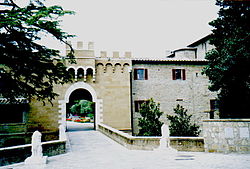
Montorio is a village in Tuscany, central Italy, administratively a frazione of the comune of Sorano, province of Grosseto, in the tuff area of southern Maremma.
Montorio | |
|---|---|
 The castle of Montorio | |
| Coordinates: 42°44′30″N 11°46′1″E / 42.74167°N 11.76694°E | |
| Country | Italy |
| Region | |
| Province | Grosseto (GR) |
| Comune | Sorano |
| Elevation | 483 m (1,585 ft) |
| Demonym | Montoriesi |
| Time zone | UTC+1 (CET) |
| • Summer (DST) | UTC+2 (CEST) |
| Postal code | 58010 |
| Dialing code | (+39) 0564 |
Geography
editMontorio is about 90 km from Grosseto and 10 km from Sorano, and it is situated along the Provincial Road which links Sorano to Castell'Azzara.
History
editIt was included — along with Castell'Ottieri, San Giovanni delle Contee and the castle of Sopano — in the small County of Ottieri in the Middle Ages. The county was abolished in 1616.[1]
Main sights
edit- Santa Maria (19th century), the main church of the village, it was built in the 19th century in the place of the ancient chapel of the castle. It is a typical Gothic Revival architecture.[2]
- Castle of Montorio (12th century), built by the Aldobrandeschi in the Middle Ages, it was then restructured by the Ottieri and then transformed into a fortified farmhouse after the annexation of the county in the Grand Duchy of Tuscany.[3]
- Walls of Montorio, old fortifications which surround the village since the 12th century.[3]
References
edit- ^ (in Italian) Emanuele Repetti, «Montorio Archived 2015-09-23 at the Wayback Machine», Dizionario Geografico Fisico Storico della Toscana, 1833-1846.
- ^ Carlo Citter, Guida agli edifici sacri della Maremma, Siena, Nuova Immagine, 2002.
- ^ a b Giuseppe Guerrini, Torri e castelli della provincia di Grosseto, Siena, Nuova Immagine, 1999.
Bibliography
edit- Aldo Mazzolai, Guida della Maremma. Percorsi tra arte e natura, Florence, Le Lettere, 1997.
See also
edit- Castell'Ottieri
- Cerreto, Sorano
- Elmo, Sorano
- Montebuono, Sorano
- Montevitozzo
- San Giovanni delle Contee
- San Quirico, Sorano
- San Valentino, Sorano
- Sovana
Wikimedia Commons has media related to Montorio (Sorano).
