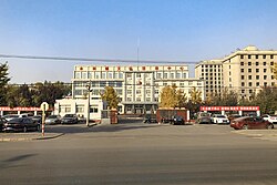
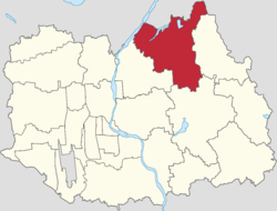
Mulin Town (simplified Chinese: 木林镇; traditional Chinese: 木林鎮; pinyin: Mùlín Zhèn) is one of the 19 towns of Shunyi District, Beijing. It borders Henanzhai Town to its north, Dongshaoqu and Longwantun Towns to its east, Yang and Beixiaoying Towns to its south, and Yangsong Town in its west. It had 34,114 inhabitants under its administration as of 2020.[1]
Mulin Town
木林镇 | |
|---|---|
 Government of Mulin Town, 2020 | |
 Location of Mulin Town within Shunyi District | |
| Coordinates: 40°14′41″N 116°46′30″E / 40.24472°N 116.77500°E | |
| Country | China |
| Municipality | Beijing |
| District | Shunyi |
| Village-level Divisions | 26 villages |
| Area | |
| • Total | 83.27 km2 (32.15 sq mi) |
| Elevation | 45 m (148 ft) |
| Population (2020) | |
| • Total | 34,114 |
| • Density | 410/km2 (1,100/sq mi) |
| Time zone | UTC+8 (China Standard) |
| Postal code | 101314 |
| Area code | 010 |
The town took its name Mulin (Chinese: 木林; lit. 'Wood Forest') from the forest on the west of the settlement during the reign of Wanli Emperor of Ming dynasty.[2]
History
edit| Time | Status | Part of |
|---|---|---|
| 1912–1949 | 3rd District | Huairou County |
| 1949–1956 | Shunyi County | |
| 1956–1958 | Mulin Township | |
| 1958–1983 | Mulin People's Commune | |
| 1983–1989 | Mulin Township | |
| 1989–1998 | Mulin Town (Incorporated Ligezhuang Township in 1997)) | |
| 1998–present | Shunyi District |
Administrative divisions
editAs of 2021, Mulin Town oversaw 26 villages:[3]
| Administrative Division Code | Subdisvision Names | Name Transliteration |
|---|---|---|
| 110113112201 | 木林 | Mulin |
| 110113112202 | 陈各庄 | Chengezhuang |
| 110113112203 | 蒋各庄 | Jianggezhuang |
| 110113112204 | 魏家店 | Weijiadian |
| 110113112205 | 东沿头 | Dong Yantou |
| 110113112206 | 西沿头 | Xi Yantou |
| 110113112207 | 长林庄 | Changlinzhuang |
| 110113112208 | 孝德 | Xiaode |
| 110113112209 | 唐指山 | Tangzhishan |
| 110113112210 | 贾山 | Jiashan |
| 110113112211 | 茶棚 | Chapeng |
| 110113112212 | 安辛庄 | Anxinzhuang |
| 110113112213 | 王泮庄 | Wangpanzhuang |
| 110113112214 | 大韩庄 | Da Hanzhuang |
| 110113112215 | 小韩庄 | Xiao Hanzhuang |
| 110113112216 | 马坊 | Mafang |
| 110113112217 | 上园子 | Shangyuanzi |
| 110113112218 | 大林 | Dalin |
| 110113112219 | 陈家坨 | Chenjiatuo |
| 110113112220 | 李各庄 | Ligezhuang |
| 110113112221 | 业兴庄 | Yexingzhuang |
| 110113112222 | 陀头庙 | Tuotoumiao |
| 110113112223 | 荣各庄 | Ronggezhuang |
| 110113112224 | 前王各庄 | Qian Wanggezhuang |
| 110113112225 | 后王各庄 | Hou Wanggezhuang |
| 110113112226 | 潘家坟 | Panjiafen |
See also
editReferences
edit- ^ "北京市顺义区第七次全国人口普查公报发布". ie.bjd.com.cn (in Chinese (China)). Retrieved 2022-10-14.
- ^ a b 李立国; 李万钧; 吴世民, eds. (2013). 中华人民共和国政区大典, 北京市卷. Beijing: 中国社会出版社. ISBN 978-7-5087-4058-4. OCLC 910451741.
- ^ "2021年统计用区划代码和城乡划分代码". www.stats.gov.cn. Retrieved 2022-10-17.

