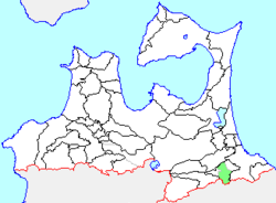
Nagawa (名川町, Nagawa-mura) was a town located in Sannohe District in central Aomori Prefecture, Japan. On January 1, 2006 Nagawa was merged into the neighboring town of Nanbu,[1] and thus it no longer exists as an independent municipality.
Nagawa
名川町 | |
|---|---|
Former municipality | |
 Location of Nagawa in Aomori Prefecture | |
| Coordinates: 40°25′17″N 141°19′57.7″E / 40.42139°N 141.332694°E | |
| Country | Japan |
| Region | Tōhoku |
| Prefecture | Aomori Prefecture |
| District | Sannohe |
| Merged | January 1, 2006 (now part of Nanbu) |
| Area | |
• Total | 83.45 km2 (32.22 sq mi) |
| Population (February 1, 2006) | |
• Total | 8,565 |
| • Density | 161.94/km2 (419.4/sq mi) |
| Time zone | UTC+09:00 (JST) |
| Symbols | |
| Flower | Hydrangea |
| Tree | Maple |
Nakui Village (名久井村) was founded on April 1, 1889 from the merger of seven small hamlets, and neighboring Kitakawa Village (北川村) was likewise formed from the merger of three small hamlets. On July 29, 1955, Nakui and Kitakawa merged to form the town of Nagawa.
On January 1, 2006, Nagawa, along with the village of Fukuchi (also from Sannohe District), was merged into the expanded town of Nanbu and thus it no longer exists as an independent municipality.
An inland village, Nagawa had an agriculture-based economy, with raising of cherries predominating. At the time of its merger, Nagawahad an estimated population of 8,656 and a population density of 161.94 persons per km2. The total area was 53.45 km2. Nagawa was served by Japan National Route 4 and Japan National Route 104 highways, and by Kenyoshi Station on the Aoimori Railway Line.
References
edit- ^ "総務省|令和2年版 地方財政白書|資料編 〔附属資料〕 昭和60年度以降の市町村合併の実績" [Record of Municipal Mergers Since Showa 60]. 総務省 (in Japanese). Retrieved 2024-02-28.


