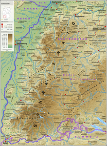
The Black Forest is categorised as a natural region of the 3rd level and is part of the South German Scarplands, where it forms the basement and escarpments of Bunter sandstone along with the major region of Odenwald, Spessart and South Rhön. According to the classification in the Handbook of the Natural Region Divisions of Germany and its successor publications in the former Bundesanstalt für Landeskunde, which are also used by the relevant Baden-Württemberg state department (LUBW), it is given the two-digit number 15; the Federal Agency for Nature Conservation (BfN), in its internal numbering system, designates it as D54.[1]

- ^ Map services of the Federal Agency for Nature Conservation In terms of "protected areas", the Black Forest, at map scales up to 1:100,000, is designated as D54; the subordinate numbers in the Landschaften map service,however, use the number 15 as do the lower level major units, following the numbering as at 1967.