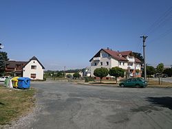
Obruby is a municipality and village in Mladá Boleslav District in the Central Bohemian Region of the Czech Republic. It has about 200 inhabitants.
Obruby | |
|---|---|
 Centre of Obruby | |
| Coordinates: 50°27′37″N 15°4′57″E / 50.46028°N 15.08250°E | |
| Country | |
| Region | Central Bohemian |
| District | Mladá Boleslav |
| First mentioned | 1408 |
| Area | |
• Total | 4.48 km2 (1.73 sq mi) |
| Elevation | 255 m (837 ft) |
| Population (2024-01-01)[1] | |
• Total | 247 |
| • Density | 55/km2 (140/sq mi) |
| Time zone | UTC+1 (CET) |
| • Summer (DST) | UTC+2 (CEST) |
| Postal code | 294 03 |
| Website | www |
Etymology
editThe name was derived from the old Czech word obrub, which can be translated as 'border', 'edge' or 'wall'.[2]
Geography
editObruby is located about 13 kilometres (8 mi) east of Mladá Boleslav and 56 km (35 mi) northeast of Prague. It lies in the Jičín Uplands. The highest point is at 320 m (1,050 ft) above sea level. The stream Přepeřský potok flows through the municipality.
History
editThe first written mention of Obruby is from 1408.[3]
Demographics
edit
|
|
| ||||||||||||||||||||||||||||||||||||||||||||||||||||||
| Source: Censuses[4][5] | ||||||||||||||||||||||||||||||||||||||||||||||||||||||||
Transport
editThe I/16 road (the section from Mladá Boleslav to Jičín) passes through the municipality.
Sights
editObruby is poor in monuments. The only protected cultural monument is a rural homestead from the end of the 18th century.[6]
References
edit- ^ "Population of Municipalities – 1 January 2024". Czech Statistical Office. 2024-05-17.
- ^ Profous, Antonín (1951). Místní jména v Čechách III: M–Ř (in Czech). p. 249.
- ^ "Obec Kovanec" (in Czech). Obec Obruby. Retrieved 2024-09-05.
- ^ "Historický lexikon obcí České republiky 1869–2011" (in Czech). Czech Statistical Office. 2015-12-21.
- ^ "Population Census 2021: Population by sex". Public Database. Czech Statistical Office. 2021-03-27.
- ^ "Výsledky vyhledávání: Kulturní památky, obec Obruby". Ústřední seznam kulturních památek (in Czech). National Heritage Institute. Retrieved 2024-09-05.
External links
edit


