Otar (Kazakh: Отар) is a village in the Zhambyl Region, south-eastern Kazakhstan. It is the administrative center of the Otar rural district (KATO code - 314851100).[1] Population: 4,540 (2009 Census results);[2] 4,355 (1999 Census results).[2][3]
Otar
Отар | |
|---|---|
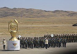
 View of the Otar Military Base in 2017 | |
| Coordinates: 43°32′15″N 75°12′32″E / 43.53750°N 75.20889°E | |
| Country | Kazakhstan |
| Region | Zhambyl Region |
| District | Korday District |
| Population (2009) | |
• Total | 4,540 |
| Time zone | UTC+6 (Omsk Time) |
| Postcode | 040306 |
Geography
editOtar is located just west of the border with the Almaty Region by the southern end of the Chu-Ili Range. 1.5 kilometers (0.93 mi) to the east of the village lies the Otar Military Base.[4][5]
Climate
editOtar has a semi-arid climate (Köppen: BSk)[6] with cold winters and hot summers.
| Climate data for Otar (1991–2020) | |||||||||||||
|---|---|---|---|---|---|---|---|---|---|---|---|---|---|
| Month | Jan | Feb | Mar | Apr | May | Jun | Jul | Aug | Sep | Oct | Nov | Dec | Year |
| Mean daily maximum °C (°F) | −1.4 (29.5) |
1.2 (34.2) |
9.8 (49.6) |
18.4 (65.1) |
24.5 (76.1) |
30.3 (86.5) |
33.0 (91.4) |
31.9 (89.4) |
26.1 (79.0) |
17.5 (63.5) |
7.6 (45.7) |
0.4 (32.7) |
16.6 (61.9) |
| Daily mean °C (°F) | −7.0 (19.4) |
−4.2 (24.4) |
3.6 (38.5) |
11.4 (52.5) |
17.1 (62.8) |
22.7 (72.9) |
25.2 (77.4) |
23.7 (74.7) |
17.6 (63.7) |
9.6 (49.3) |
1.3 (34.3) |
−4.9 (23.2) |
9.7 (49.5) |
| Mean daily minimum °C (°F) | −11.5 (11.3) |
−8.5 (16.7) |
−1.5 (29.3) |
5.0 (41.0) |
9.6 (49.3) |
14.6 (58.3) |
16.8 (62.2) |
14.9 (58.8) |
9.0 (48.2) |
2.9 (37.2) |
−3.2 (26.2) |
−8.9 (16.0) |
3.3 (37.9) |
| Average precipitation mm (inches) | 18.2 (0.72) |
20.6 (0.81) |
26.7 (1.05) |
48.4 (1.91) |
44.6 (1.76) |
36.8 (1.45) |
32.4 (1.28) |
15.3 (0.60) |
15.7 (0.62) |
31.5 (1.24) |
31.4 (1.24) |
20.9 (0.82) |
342.5 (13.48) |
| Average precipitation days (≥ 1.0 mm) | 4.9 | 5.5 | 5.5 | 7.7 | 6.9 | 6.8 | 5.5 | 2.8 | 2.6 | 4.3 | 5.6 | 5.1 | 63.2 |
| Source: NOAA[7] | |||||||||||||
History
editDuring World War II, in 1942, the 1st Uhlan Regiment of the Polish Anders' Army was stationed and organized in Otar, before it was evacuated from Kazakhstan to fight against Nazi Germany.[8]
References
edit- ^ "База КАТО". Агентство Республики Казахстан по статистике. Archived from the original on 2013-09-27.
- ^ a b "Население Республики Казахстан" [Population of the Republic of Kazakhstan] (in Russian). Департамент социальной и демографической статистики. Retrieved 8 December 2013.
- ^ "Итоги Национальной переписи населения Республики Казахстан 2009 года" (PDF). Агентство Республики Казахстан по статистике. Archived from the original (PDF) on 2013-05-13.
- ^ "M-43 Topographic Chart (in Russian)". Retrieved 3 October 2022.
- ^ Google Earth.
- ^ "Table 1 Overview of the Köppen-Geiger climate classes including the defining criteria". Nature: Scientific Data.
- ^ "World Meteorological Organization Climate Normals for 1991-2020 — Otar". National Oceanic and Atmospheric Administration. Retrieved January 18, 2024.
- ^ "Tworzenie Armii Polskiej w ZSRS w 1941–1942" (PDF). Instytut Pamięci Narodowej (in Polish). Retrieved 9 December 2023.
External links
edit
