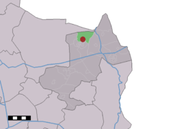
Oud Ootmarsum is a hamlet in the Dutch province of Overijssel. It is a part of the municipality of Dinkelland, and lies about 12 km north of Oldenzaal and very close to Ootmarsum.
Oud Ootmarsum | |
|---|---|
hamlet | |
 Old style barn | |
| Nickname: Héénige Slépvént Land | |
 The village (dark red) and the statistical district (light green) of Oud Ootmarsum in the municipality of Dinkelland. | |
| Coordinates: 52°25′03″N 6°54′28″E / 52.4175°N 6.9079°E | |
| Country | Netherlands |
| Province | Overijssel |
| Municipality | Dinkelland |
| Area | |
• Total | 7.48 km2 (2.89 sq mi) |
| Elevation | 31 m (102 ft) |
| Population | |
• Total | 320 |
| • Density | 43/km2 (110/sq mi) |
| Demonym | Oud-Ootmarsumers |
| Time zone | UTC+1 (CET) |
| • Summer (DST) | UTC+2 (CEST) |
| Postal code | 7637[1] |
| Dialing code | 0541 |
Oud Ootmarsum is a statistical entity and has its own postal code,[1][3] however it is considered a hamlet.[4] The hamlet is the predecessor of the city of Ootmarsum, and was first mentioned in 1384 as Olde Oetmarsum.[5] In 1840, it was home to 245 people.[4]
The partially timber-framed building style of barns and farmhouses here is closely related to the building style of the Low German house.
Gallery
edit-
Old style barn
-
Old style farmhouse
-
Former watermill
References
edit- ^ a b c d "Kerncijfers wijken en buurten 2021". Central Bureau of Statistics. Retrieved 15 March 2022.
- ^ "Postcodetool for 7637PA". Actueel Hoogtebestand Nederland (in Dutch). Het Waterschapshuis. Retrieved 15 March 2022.
- ^ "Postcode 7637 in Oud Ootmarsum". Postcode bij adres (in Dutch). Retrieved 15 March 2022.
- ^ a b "Oud Ootmarsum". Plaatsengids (in Dutch). Retrieved 15 March 2022.
- ^ "Oud-Ootmarsum". Etymologiebank (in Dutch). Retrieved 15 March 2022.
Wikimedia Commons has media related to Oud Ootmarsum.

