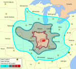
The 1968 Illinois earthquake was the largest recorded earthquake in the "Prairie State", measuring 5.4 on the Richter scale. Although there were no fatalities, the earthquake caused considerable structural damage to buildings, including the toppling of chimneys. The earthquake was one of the most widely felt in U.S. history, affecting 23 states over an area of 580,000 square miles (1,500,000 km2). In studying its cause, scientists discovered the Cottage Grove Fault in the Southern Illinois Basin.
Within the region, millions felt the rupture. Reactions to the earthquake varied: some people near the epicenter did not react to the shaking, while others panicked. A future earthquake in the region is extremely likely; seismologists and geologists estimate a 90% chance of a magnitude 6–7 tremor before 2055, likely originating in the Wabash Valley seismic zone on the Illinois–Indiana border, or the New Madrid fault zone. (Read more...)