Selected picture 1
Portal:Weather/Selected picture/1

A blizzard has swept the snow on these trees on The Brocken (Harz, Germany) into weird shapes.
Recently selected pictures: Low pressure
Selected picture 2
Portal:Weather/Selected picture/2

Lightning strikes in the outskirts of Oradea, Romania, during a thunderstorm on August 17, 2005. This storm system went on to cause major flash floods over Southern Romania.
Recently selected pictures: Snow-swept trees, Low pressure
Selected picture 3
Portal:Weather/Selected picture/3

Crepuscular rays, in atmospheric optics, are rays of sunlight that appear to radiate from a single point in the sky. These rays, which stream through gaps in clouds, are parallel columns of sunlit air separated by darker cloud-shadowed regions. The term "crepuscular" comes from their frequent occurrences during twilight, when the contrasts between light and dark are the most obvious. Various aerosols scatter the sunlight and make these rays visible. The reason we see the light so defined is because of diffraction, reflection and scattering. Crepuscular rays are near-parallel, but appear to diverge because of linear perspective. They often occur when objects such as mountain peaks or clouds partially shadow the sun's rays.
Recently selected pictures: Cumulonimbus cloud, Ice storm leaves, Mackerel sky, More...
Selected picture 4
Portal:Weather/Selected picture/4

A cumulonimbus cloud near Swifts Creek, Victoria, Australia. Cumulonimbus are so named because they combine the characteristics of cumulus clouds (puffy in nature) and nimbus clouds (causing precipitation). They are typically around 30,000-50,000 ft (10,000-15,000 m) in height, and commonly produce precipitation and lightning. Cumulonimbus clouds occasionally become severe thunderstorms, and, if rotation is present in the atmosphere, can become supercells, producing high winds, heavy rain, hail, and rarely tornadoes. Fortunately, this only happens in a small fraction of cases; most cumulonimbus produce innocuous showers or thundershowers.
Recently selected pictures: Ice storm leaves, Mackerel sky, Lightning over Romania, More...
Selected picture 5
Portal:Weather/Selected picture/5
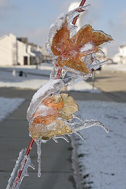
Recently selected pictures: Mackerel sky, Lightning over Romania, Snow-swept trees, More...
Selected picture 6
Portal:Weather/Selected picture/6

Recently selected pictures:
Selected picture 7
Portal:Weather/Selected picture/7

Mammatus (also known as mamma or mammatocumulus, meaning "breast-cloud") is a meteorological term applied to a cellular pattern of pouches hanging underneath the base of a cloud. The name "mammatus" is derived from the Latin mamma (breast), due to the resemblance between the shape of these clouds and human female breasts. Mammatus are most often found on the anvil cloud that extends from a cumulonimbus, and therefore are commonly associated with severe weather.
Recently selected pictures: Von Kármán vortex street, Crepuscular rays, Cumulonimbus cloud, More...
Selected picture 8
Portal:Weather/Selected picture/8

The May 22-23, 1981 Tornado Outbreak was a series of destructive tornadoes which injured 12 people and caused $32.8 million (1981 USD) in damage. However, the outbreak is most notable for the spectacularly photogenic Cordell, Oklahoma tornado seen above, which has appeared in many tornado videos and documentaries. Tornadoes are normally oriented vertically, however this tornado was impacted by a gust front from its parent thunderstorm, which stretched it in a horizontal direction. The tornado produced F2 damage, and dissipated shortly after this photo was taken.
Recently selected pictures: Mammatus clouds, Von Kármán vortex street, Crepuscular rays, More...
Selected picture 9
Portal:Weather/Selected picture/9

This dust storm occurred around Spearman, Texas on April 14, 1935. This was in the heart of the Dust Bowl, a period of severe dust storms and drought, which contributed to the Great Depression in the United States.
Recently selected pictures: Cordell, Oklahoma tornado, Mammatus clouds, Von Kármán vortex street, More...
Selected picture 10
Portal:Weather/Selected picture/10

A pickup truck was wrapped around this utility pole by the extreme winds from the Moore, Oklahoma tornado which occurred on 1999-05-03. The truck was then pummelled by winds which exceeded 200 mph (320 km/h), stripping most of the sheet metal off the truck. The F5 tornado was one of the most severe ever observed, and destroyed more than 1500 homes, killing 36 people.
Recently selected pictures: Spearman, Texas dust storm, Cordell, Oklahoma tornado, Mammatus clouds, More...
Selected picture 11
Portal:Weather/Selected picture/11
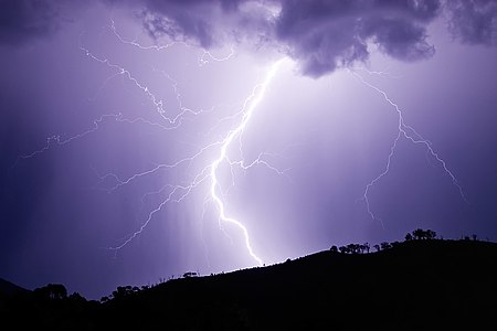
A bolt of lightning struck just behind this hill, near Swifts Creek, Victoria, Australia. Lightning kills more people than any other thunderstorm phenomenon (including tornadoes), and strikes approximately 100 times per second across the world.
Recently selected pictures: Moore, Oklahoma tornado damage, Spearman, Texas dust storm, Cordell, Oklahoma tornado, More...
Selected picture 12
Portal:Weather/Selected picture/12

View of the eyewall of Hurricane Katrina taken on August 28, 2005, as seen from a NOAA WP-3D Orion hurricane hunter aircraft before the storm made landfall on the United States Gulf Coast.
Recently selected pictures: Lightning strike near Swifts Creek, Victoria, Australia, Spearman, Texas dust storm, Cordell, Oklahoma tornado, More...
Selected picture 13
Portal:Weather/Selected picture/13

The eye of Hurricane Isabel approaches North Carolina's Outer Banks in this true-color Moderate Resolution Imaging Spectroradiometer (MODIS) image captured by the Terra satellite on September 18, 2003 at 11:55 am US Eastern time.
Recently selected pictures: Hurricane Katrina Eye, Lightning strike near Swifts Creek, Victoria, Australia, Spearman, Texas dust storm, More...
Selected picture 14
Portal:Weather/Selected picture/14

Virga is precipitation which evaporates before reaching the ground, forming a translucent, wispy cloud. It can be seen descending from the dark foreground clouds over the London skyline in this May, 2007 photograph.
Recently selected pictures: Hurricane Isabel satellite, Hurricane Katrina Eye, Lightning strike near Swifts Creek, Victoria, Australia, More...
Selected picture 15
Portal:Weather/Selected picture/15

Ground fog is a name given to fog that forms a shallow layer near the ground, sometimes just tens of centimeters thick. It can form due to warm air moving over a colder surface (advection fog), or at night due to the escape of thermal radiation into space (radiation fog). This scene is in East Frisia, Germany just after sunrise.
Recently selected pictures: Virga over London, Hurricane Isabel satellite, Hurricane Katrina Eye, More...
Selected picture 16
Portal:Weather/Selected picture/16
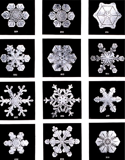
Different types of snowflakes are shown in this series of photos, taken by Wilson Bentley in 1902. The phrase "no two snowflakes are alike" is mostly based in truth, as their shape, size, and branching features are highly sensitive to the exact humidity, temperature, and other atmospheric conditions in which they form.
Recently selected pictures: Ground fog, Virga over London, Hurricane Isabel satellite, More...
Selected picture 17
Portal:Weather/Selected picture/17

Hoar frost is a loose covering of ice crystals which forms on objects due to radiational cooling. This scene is in Lower Saxony, Germany.
Recently selected pictures: Snowflakes, Ground fog, Virga over London, More...
Selected picture 18
Portal:Weather/Selected picture/18

A roll cloud off the coast of Punta del Este, Uruguay. Roll clouds are formed by strong outflow from a thunderstorm forcing surrounding air upwards.
Recently selected pictures: Hoar frost, Snowflakes, Ground fog, More...
Selected picture 19
Portal:Weather/Selected picture/19

Cyclone Catarina, the only major tropical cyclone ever observed in the Southern Atlantic Ocean, as it appeared from the International Space Station on March 26, 2004.
Recently selected pictures: Roll cloud, Hoar frost, Snowflakes, More...
Selected picture 20
Portal:Weather/Selected picture/20
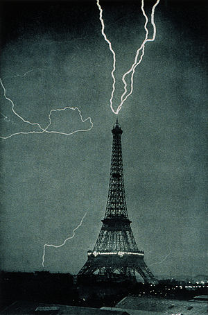
Lightning striking the Eiffel Tower on the night of June 3, 1902. This is one of the earliest photographs of lightning in an urban setting.
Recently selected pictures: Cyclone Catarina, Roll cloud, Hoar frost, More...
Selected picture 21
Portal:Weather/Selected picture/21
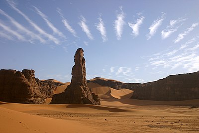
An atmospheric gravity wave manifests itself as altocumulus undulatus clouds in an arid environment, in the Tadrart Acacus region of southeast Algeria.
Recently selected pictures: Lightning striking the Eiffel Tower, Cyclone Catarina, Roll cloud, More...
Selected picture 22
Portal:Weather/Selected picture/22
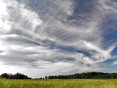
A variety of cirrus and cirrostratus clouds over a field.
Recently selected pictures: Altocumulus undulatus, Lightning striking the Eiffel Tower, Cyclone Catarina, More...
Selected picture 23
Portal:Weather/Selected picture/23

The eye of Hurricane Isabel as seen from the International Space Station.
Recently selected pictures: Cirrus and cirrostratus clouds, Altocumulus undulatus, Lightning striking the Eiffel Tower, More...
Selected picture 24
Portal:Weather/Selected picture/24

Cloud-to-cloud lightning from a nighttime thunderstorm in Zwickau, Germany.
Recently selected pictures: Eye of Hurricane Isabel, Cirrus and cirrostratus clouds, Altocumulus undulatus, More...
Selected picture 25
Portal:Weather/Selected picture/25

Pyrocumulus clouds caused by a wildfire in Yellowstone National Park.
Recently selected pictures: Cloud-to-cloud lightning, Eye of Hurricane Isabel, Cirrus and cirrostratus clouds, More...
Selected picture 26
Portal:Weather/Selected picture/26

Two sun dogs, also known as "mock suns", appear to the left and right of the sun outside of New Ulm, Minnesota, United States. Sun dogs are an optical phenomenon caused by ice crystals either suspended near the surface during cold weather or in high clouds.
Recently selected pictures: Pyrocumulus clouds, Cloud-to-cloud lightning, Eye of Hurricane Isabel, More...
Selected picture 27
Portal:Weather/Selected picture/27

Flakes of snow highly magnified by a low-temperature scanning electron microscope (SEM). The colors are called "pseudo colors"; they are computer generated and are a standard technique used with SEM images.
Recently selected pictures: Sun dog,Pyrocumulus clouds, Cloud-to-cloud lightning, More...
Selected picture 28
Portal:Weather/Selected picture/28
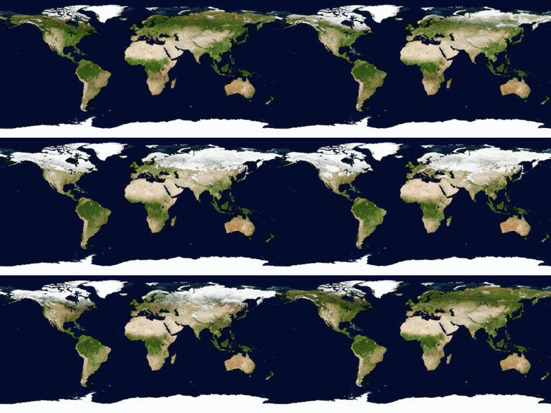
An animation of changing snow cover across the Earth over the period of a year. Snow cover is much more abundant in the Northern Hemisphere, which is not surprising considering that the large majority of land in the colder latitudes is in the Northern Hemisphere. Antarctica is perennially covered by snow or ice cap, except for a few places in the Antarctic Peninsula and the McMurdo Dry Valleys.
Recently selected pictures: Snow flakes, Sun dogs, Pyrocumulus clouds, More...
Selected picture 29
Portal:Weather/Selected picture/29

Parallax is the phenomenon of the change in the apparent position of an object when viewed from different angles. It is demonstrated nicely in this foggy scene, where the reflection of the moon appears in a different position with respect to the street lamp when viewed in the reflection in the water.
Recently selected pictures: Global snow cover, Snow flakes, Sun dogs, More...
Selected picture 30
Portal:Weather/Selected picture/30

A dust storm is a meteorological phenomenon where strong winds lift loose dust from arid and semi-arid regions, often transporting the particles long distances. These storms can continue hundreds of miles from their source, and can have drastic effects on human health, transportation, and society in general. This storm occurred in May 2005 over the Red Sea.
Recently selected pictures: Parallax, Global snow cover, Snow flakes, More...
Selected picture 31
Portal:Weather/Selected picture/31

This tornado struck the town of Elie, Manitoba on June 22, 2007. It was the first tornado outside the United States to be rated F5 on the Fujita Scale, the most severe level of tornado damage.
Recently selected pictures: Dust storm, Parallax, Global snow cover, More...
Selected picture 32
Portal:Weather/Selected picture/32

A noctilucent cloud photographed from Soomaa National Park, Estonia. Noctilucent clouds are the highest clouds that form on Earth, being found in the mesosphere at altitudes of more than 70 kilometres (43 mi) above the ground. They are also among the rarest seen types of clouds: they are very dim (can only be seen after sunset illuminated by the sun below the horizon), and are typically only seen at latitudes between 50 and 70 degrees from the equator during the summertime.
Selected picture 33
Portal:Weather/Selected picture/33

Ground fog is a name given to fog that forms a shallow layer near the ground, sometimes just tens of centimeters thick. It can form due to warm air moving over a colder surface (advection fog), or at night due to the escape of thermal radiation into space (radiation fog). This scene is in Nordstemmen, Lower Saxony, Germany just after sunset.
Previously selected pictures: noctilucent cloud, Elie, Manitoba tornado, Dust storm from space, More...
Selected picture 34
Portal:Weather/Selected picture/34

Cyclone Gafilo was both the most intense tropical cyclone ever recorded in the South-West Indian Ocean and the most intense tropical cyclone worldwide in 2004. This image was take by the Moderate Resolution Imaging Spectroradiometer on the Terra Earth Observing System satellite on March 6, 2004 as the storm approached northeastern Madagascar. Gafilo would go on to kill more than 300 people in the country.
Previously selected pictures: Ground fog, Noctilucent cloud, Elie, Manitoba tornado, More...
Selected picture 35
Portal:Weather/Selected picture/35
