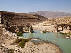
Qara Aghaj (from Turkish Karaağaç meaning elm) river is one of the most important rivers in the Fars province of Iran with a length of 700 km and its water is currently used for drinking and agricultural purposes. Salman Farsi Dam is located on the river between Jahrom, Simkan (Dozeh) and Qir and Karzin districts.
| Qara Aqaj river | |
|---|---|
 Sasanian Bridge on Qarah Aqaj river in Kavar City | |
| Location | |
| Country | Iran |
| State | Fars |
| Physical characteristics | |
| Length | 700km |
This river is formed by joining the springs of Kan Zard, Chehel Cheshmeh Koohmareh and Sarkhark in Khan Zanian and after leaving the Arjan section of Shiraz,[1] it enters Kavar city and after passing through the agricultural lands of Kavar, Khafr, Simakan, Qiro and Karzin through Mand river enters the Persian Gulf.
The water of this river is permanent and its width reaches 20 meters in mountainous areas and 400 meters in the plains. The average annual flow of this river is 18 cubic meters per second at Tang Karzin station.[2] The minimum flow in this station is 3.5 cubic meters per second[3] and the maximum is 43 cubic meters per second. In the case of floods, the recorded statistics show a discharge of 6,000 cubic meters.[4][5]
References
edit- ^ "سازمان حفاظت محیط زیست -استان فارس-صفحه جدید استان فارس/ماموران و همیاران محیط زیست فارس،ماهیان را در رود قرهآغاج رها کردند". fars.doe.ir. Retrieved 2022-04-02.
- ^ "مردم به حاشیه رودخانه قره آغاج نروند". IRIB News Agency (in Persian). April 16, 2009. Retrieved April 2, 2022.
- ^ "تلاش برای مدیریت شوری آب قرهآغاج". fa (in Persian). Retrieved 2022-04-02.
- ^ جشنی, ایوب کریمی; پورکریمی, علی; بیدختی, ناصر طالب (27 June 1385). "شناسایی منابع آلاینده رودخانه قره آغاج" (in Persian). سومین کنگره ملی مهندسی عمران.
{{cite journal}}: Cite journal requires|journal=(help) - ^ "رفع تصرف ۱۵ هکتار اراضی حاشیه رودخانه قره آغاج - نمایش محتوای خبر - صدا و سیمای فارس". fars.irib.ir. Retrieved 2022-04-02.