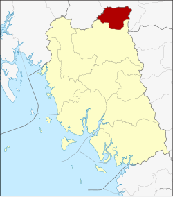
Ratsada (Thai: รัษฎา, pronounced [rát.sā.dāː]) is a district (amphoe) in the northeastern part of Trang province, Thailand.
Ratsada
รัษฎา | |
|---|---|
 | |
 District location in Trang province | |
| Coordinates: 7°58′30″N 99°38′0″E / 7.97500°N 99.63333°E | |
| Country | Thailand |
| Province | Trang |
| Seat | Khlong Pang |
| Area | |
• Total | 232.4 km2 (89.7 sq mi) |
| Population (2005) | |
• Total | 26,381 |
| • Density | 113.5/km2 (294/sq mi) |
| Time zone | UTC+7 (ICT) |
| Postal code | 92160 |
| Geocode | 9209 |
History
editThe minor district (king amphoe) Ratsada was established on 1 April 1991 by splitting off five tambons from Huai Yot district.[1] It was upgraded to a full district on 5 December 1996.[2]
Geography
editNeighboring districts are (from the south clockwise): Huai Yot of Trang Province; Bang Khan and Thung Song of Nakhon Si Thammarat province.
Administration
editThe district is divided into five sub-districts (tambons), which are further subdivided into 50 villages (mubans). Khlong Pang is a township (thesaban tambon) which covers parts of tambon Khlong Pang. There are a further five tambon administrative organizations (TAO).
|
Notable people
edit- Oleydong Sithsamerchai: professional boxer
References
edit- ^ ประกาศกระทรวงมหาดไทย เรื่อง แบ่งเขตท้องที่อำเภอห้วยยอด จังหวัดตรัง ตั้งเป็นกิ่งอำเภอรัษฎา (PDF). Royal Gazette (in Thai). 108 (15 ง): 1071. January 31, 1991. Archived from the original (PDF) on June 1, 2012.
- ^ พระราชกฤษฎีกาตั้งอำเภอเหนือคลอง อำเภอนายายอาม อำเภอท่าตะเกียบ อำเภอขุนตาล อำเภอแม่ฟ้าหลวง อำเภอแม่ลาว อำเภอรัษฎา อำเภอพุทธมณฑล อำเภอวังน้ำเขียว อำเภอเจาะไอร้อง อำเภอชำนิ อำเภอโนนดินแดง อำเภอปางมะผ้า อำเภอสนธิ อำเภอหนองม่วง อำเภอเบญจลักษ์ อำเภอโพนนาแก้ว อำเภอบุ่งคล้า อำเภอดอนมดแดง และอำเภอลืออำนาจ พ.ศ. ๒๕๓๙ (PDF). Royal Gazette (in Thai). 113 (62 ก): 5–8. November 20, 1996. Archived from the original (PDF) on May 21, 2009.
External links
edit- [1] (Thai)
- amphoe.com