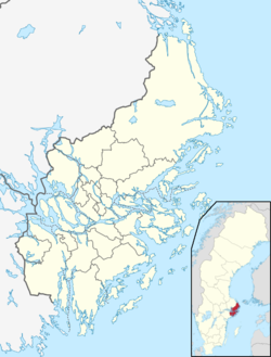
Resarö is an island in the Stockholm archipelago and a locality in Vaxholm Municipality, Stockholm County, Sweden. It had 3,212 inhabitants in 2020. Resarö includes the hamlet of Ytterby, famous for the discovery of several rare-earth elements in a local mine.[1][2]
Resarö | |
|---|---|
 Resarö waterfront | |
| Coordinates: 59°26′N 18°20′E / 59.433°N 18.333°E | |
| Country | Sweden |
| Province | Uppland |
| County | Stockholm County |
| Municipality | Vaxholm Municipality |
| Area | |
• Total | 3.50 km2 (1.35 sq mi) |
| Population (31 December 2020)[1] | |
• Total | 3,212 |
| • Density | 951/km2 (2,460/sq mi) |
| Time zone | UTC+1 (CET) |
| • Summer (DST) | UTC+2 (CEST) |
At its southern end, the island is crossed by county road 274, with a bridge to the south linking it to the island of Kullö and, via that, to the Vaxholm urban area. To the west, a bridge links to the mainland via the islet of Bullerholmen. Local roads connect the county road with centres of population to the north of the island. Except for the winter months, passenger ships of the Waxholmsbolaget call at a pier in Ytterby, providing a connection to Vaxholm town and Stockholm city.[2][3][4][5]
The name
editThe old form of the name was Risarna. The first element is ris 'brushwood' - the last element is derived from arin 'gravel; island made by gravel'. The last element ö 'island' was added in the 16th century.[citation needed]
References
edit- ^ a b c "Statistiska tätorter 2020, befolkning, landareal, befolkningstäthet per tätort" (in Swedish). Statistics Sweden. Archived from the original on 26 May 2023. Retrieved 25 May 2023.
- ^ a b "Interactive map - Resarö". hitta.se. Archived from the original on 30 May 2023. Retrieved 30 May 2023.
- ^ "Vaxholms broar" [Vaxholm's bridges]. Upplevvaxholm.se (in Swedish). Archived from the original on 26 May 2023. Retrieved 26 May 2023.
- ^ "Ferry Network Map" (PDF). Archived (PDF) from the original on 31 May 2023. Retrieved 31 May 2023.
- ^ "Ytterby". Archived from the original on 7 June 2023. Retrieved 7 June 2023.


