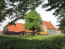
Rilland is a village in the Dutch province of Zeeland. It is located in the municipality of Reimerswaal.
Rilland | |
|---|---|
Village | |
 Farm in Rilland | |
| Coordinates: 51°24′59″N 4°10′51″E / 51.41639°N 4.18083°E | |
| Country | Netherlands |
| Province | Zeeland |
| Municipality | Reimerswaal |
| Area | |
• Total | 56.95 km2 (21.99 sq mi) |
| Elevation | 1.6 m (5.2 ft) |
| Population (2021)[1] | |
• Total | 3,015 |
| • Density | 53/km2 (140/sq mi) |
| Time zone | UTC+1 (CET) |
| • Summer (DST) | UTC+2 (CEST) |
| Postal code | 4411[1] |
| Dialing code | 0113 |
History
editThe village was first mentioned in 1186 as Relant, and means land and reed. The name was originally used for the former island which contained the village.[3] The original village was lost in a flood in 1530. In 1773, the Reigersbergsepolder was completed and Rilland developed as a road village.[4]
The Reformed Church was built in 1899. It is a small aisleless church. The front of the church was renewed after the 1953 flood. The Catholic St Joseph church was built in 1903 next to the Capuchin monastery. The monastery was disestablished in 1966 and has become a hotel.[4]
Rilland was home to 366 people in 1840.[5] In 1856, the harbour Rattekaai was constructed and was primarily used for the transportation of sugar beet. A little marina has been added to the west of the harbour.[5]
Rilland was severely damaged during the North Sea flood of 1953. The water rose to 2.5 metres (8 ft 2 in) and 12 people died.[6]
Rilland was a separate municipality until 1878, when it merged with Bath to create the new municipality of Rilland-Bath.[7] In 1970, it became part of the municipality of Reimerswaal.[5] Rilland is known for its various outdoor activities in the surrounding area. It is one of the few villages in Zeeland that has a shooting range, motor cross and golf course.
Transportation
editThe Rilland-Bath railway station opened in 1872 on the Roosendaal to Vlissingen railway line.[8]
References
edit- ^ a b c "Kerncijfers wijken en buurten 2021". Central Bureau of Statistics. Retrieved 20 April 2022.
includes Bath
- ^ "Postcodetool for 4411AA". Actueel Hoogtebestand Nederland (in Dutch). Het Waterschapshuis. Retrieved 20 April 2022.
- ^ "Rilland - (geografische naam)". Etymologiebank (in Dutch). Retrieved 20 April 2022.
- ^ a b Piet van Cruyningen & Ronald Stenvert (2003). Rilland (in Dutch). Zwolle: Waanders. ISBN 90 400 8830 6. Retrieved 20 April 2022.
- ^ a b c "Rilland". Plaatsengids (in Dutch). Retrieved 20 April 2022.
- ^ "Rilland". Zalig-Zeeland (in Dutch). Retrieved 20 April 2022.
- ^ Ad van der Meer and Onno Boonstra, Repertorium van Nederlandse gemeenten, KNAW, 2011.
- ^ "station Rilland- Bath". Stationsweb (in Dutch). Retrieved 20 April 2022.


