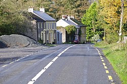
Rockmills (Irish: Carraig an Mhuileann) is a small rural village located in the parish of Kildorrery, in the Avondhu region of County Cork, Ireland. The village derives its name from the large mill that once operated on the banks of the River Funshion, that runs to the east of the village.[1][2] Rockmills is part of the Cork East (Dáil constituency).
Rockmills
Carraig an Mhuileann | |
|---|---|
Village | |
 The R512 road passes through Rockmills | |
| Coordinates: 52°13′21″N 08°24′46″W / 52.22250°N 8.41278°W | |
| Country | Ireland |
| Province | Munster |
| County | County Cork |
| Time zone | UTC+0 (WET) |
| • Summer (DST) | UTC-1 (IST (WEST)) |
The flour mills was the scene of a sharp fight during the Whiteboy risings, when it was attacked to capture the money kept on hands for the purchase of wheat. The assailants were repulsed with the loss of seven lives.[3]
A freestanding three-stage tower and spire exists, built 1812. It is the former west end of St Nathlash Church of Ireland, the rest of building demolished 1889.[4]
Transport
editLocal Link route 245C serves Rockmills several times a day Mondays to Saturdays inclusive linking it to Fermoy, Mitchelstown, Kildorrery and Glanworth.
See also
editReferences
edit- ^ Placenames Database of Ireland. Scanned records. Carraig an Mhuileann Verified 2014-10-10.
- ^ "Maps of Rockmills (select map series)". Ordnance Survey of Ireland. Retrieved 11 October 2014.
- ^ Historical and Topographical Notes etc. on Buttevant, Castletownroche, Doneraile, Mallow and places in their vicinity, by Colonel James Grove White. Cork, Guy and Company, 1906-1915. Rockmills Village, page 180. Verified 2014-10-11.
- ^ National Inventory of Architectural Heritage. St Nathlash Church Verified 2014-10-10.
External links
edit
