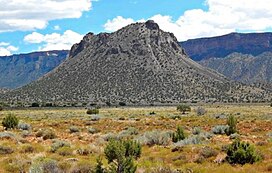
Round Mountain is a small 6,185-foot (1,885 m) summit made of gray hornblende plagioclase trachyte in the Castle Valley in southeastern Grand County, Utah, United States. It is located two miles (3.2 km) southeast of Castle Valley, Utah, and about 10 miles (16 km) east-northeast of Moab. Round Mountain is an extinct bysmalith, or igneous volcanic plug, that rises 1,000 feet (305 m) above the valley floor in 0.4 miles (0.64 km). Precipitation runoff from the mountain drains into Castle Creek, which is a tributary of the Colorado River. The nearest higher peak is Castleton Tower, 1.42 miles (2.29 km) to the north.[1]
| Round Mountain | |
|---|---|
 Round Mountain, north aspect | |
| Highest point | |
| Elevation | 6,185 ft (1,885 m)[1] |
| Prominence | 705 ft (215 m)[1] |
| Parent peak | Horse Mountain[2] |
| Isolation | 2.65 mi (4.26 km)[2] |
| Coordinates | 38°36′46″N 109°21′43″W / 38.6128999°N 109.3618362°W[3] |
| Geography | |
| Location | Grand County, Utah United States |
| Parent range | Colorado Plateau La Sal Mountains[1] |
| Topo map | USGS Warner Lake |
| Geology | |
| Rock type | Gray hornblende plagioclase trachyte |
| Climbing | |
| Easiest route | class 2[2] |
Climate
editSpring and fall are the most favorable seasons to visit Round Mountain. According to the Köppen climate classification system, it is located in a cold semi-arid climate zone with cold winters and hot summers.[4] Summers highs rarely exceed 100 °F (38 °C). Summer nights are comfortably cool, and temperatures drop quickly after sunset. Winters are cold, but daytime highs are usually above freezing. Winter temperatures below 0 °F (−18 °C) are uncommon, though possible. This desert climate receives less than 10 inches (250 millimeters) of annual rainfall, and snowfall is generally light during the winter.
See also
editReferences
edit- ^ a b c d "Round Mountain, Utah". Peakbagger.com.
- ^ a b c "Round Mountain - 6,185' UT". listsofjohn.com. Retrieved 2024-09-05.
- ^ U.S. Geological Survey Geographic Names Information System: Round Mountain
- ^ Peel, M. C.; Finlayson, B. L. & McMahon, T. A. (2007). "Updated world map of the Köppen−Geiger climate classification". Hydrol. Earth Syst. Sci. 11 (5): 1633–1644. Bibcode:2007HESS...11.1633P. doi:10.5194/hess-11-1633-2007. ISSN 1027-5606. S2CID 9654551.
External links
editMedia related to Round Mountain (Grand County, Utah) at Wikimedia Commons

