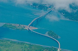
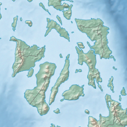
San Juanico Strait (Waray: Sulang han San Juanico) is a narrow strait in the Eastern Visayan region in the Philippines.[1] It separates the islands of Samar and Leyte and connects Carigara Bay (Samar Sea) with the San Pedro Bay (Leyte Gulf). It is about 38 kilometres (24 mi) long.[citation needed] At its narrowest point, the strait is only 2 kilometers (1.2 mi) wide.[2]
| San Juanico Strait | |
|---|---|
 Aerial view of the San Juanico Bridge over the strait | |
| Location | |
| Coordinates | 11°20′25″N 124°58′42″E / 11.34028°N 124.97833°E |
| Type | strait |
The strait is crossed by the San Juanico Bridge. The HVDC Leyte–Luzon power line also crosses the strait through an overhead line at 11°23′36″N 124°59′04″E / 11.39333°N 124.98444°E, using a tower on an uninhabited island in the strait.[citation needed] The Tacloban City harbor, the main port of the Eastern Visayas, is on Cancabato Bay at the southern entrance of the strait.[3]
Gallery
edit-
View of the San Juanico Bridge over the strait, looking southeastward.
-
The San Juanico Bridge at night.
-
1900 map of the strait.
References
edit- ^ "San Juanico Strait: Philippines". Geographical Names. Geographic.org. Retrieved 28 October 2013.
- ^ "Endless Samar". Manila Bulletin. 2 February 2018. Archived from the original on 26 March 2018. Retrieved 26 March 2018.
- ^ "Port Management Office of Tacloban". Philippine Ports Authority. Archived from the original on 28 July 2016. Retrieved 26 March 2018.
External links
edit- Media related to San Juanico Strait at Wikimedia Commons

