Shwethaungyan Subtownship (Burmese: ရွှေသောင်ယံမြို့နယ်ခွဲ [ʃwè.ð̆àʊɰ̃.jàɰ̃ mjo̼.nɛ̀.kʰu̯ɛ́]), also spaced out as Shwe Thaung Yan, is a subtownship in Pathein District, Ayeyarwady Region, Myanmar. The subtownship is split between Pathein Township and Thabaung Township; it has a total area of 178.50 square miles (462.3 km2),[1] with 153.16 square miles (396.7 km2) in Pathein and 25.34 square miles (65.6 km2) in Thabaung.[2]
Shwethaungyan Subtownship
ရွှေသောင်ယံမြို့နယ်ခွဲ Shwe Thaung Yan Subtownship | |
|---|---|
Subtownship | |
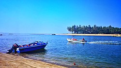
 View of Chaungtha Island from Chaungtha Beach | |
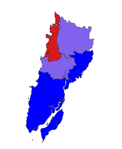
 Location in Pathein district | |
| Coordinates: 17°5′N 94°30′E / 17.083°N 94.500°E | |
| Country | |
| Region | Ayeyawady Region |
| District | Pathein District |
| Township | Pathein Township |
| Area | |
• Total | 178.5 sq mi (462.3 km2) |
| Population (2014)[1] | 49,538 |
| Time zone | UTC+6:30 (MST) |
Communities
editThe namesake of the subtownship is the town of Shwethaungyan, within Pathein Township. Shwethaungyan is home to a mangrove forest formed from the Magyi tidal cheek.[3] The town has is divided into 3 urban wards with a total area of 1.48 square miles (3.8 km2).[2]
The largest town is Chaungtha, a beach resort popular with locals or weekend travellers from Yangon.[4] In 2014, Chaungtha had total population of 3,077 people. The surrounding village tract around Chaungtha, had 27,941 people.[1]
The village of Phoe Htaung Gyaing, north of Shwethaungyan, lies near tidal seagrass meadows where seagrasses are exposed to air in low tides.[5]
Geography
editThe subtownship is coastal, bordering the Bay of Bengal to its west. To its north, it borders Gwa Township, Rakhine State. To its south and east, it borders the remaining parts of Pathein Township and Thabaung Township.[2]
Outside of its coastal areas, the subtownship is largely undeveloped and is home to a diverse variety of flora and fauna. The 39 primary tree species identified within the Pathein township portion include trees include hardwoods like teak and Burmese ironwood, fruit trees like mango and tamarind as well as coastal trees like Coconut trees.[2] The Thabaung Township region has trees including pyinkado, Indian laurel, rattan, mango, and several varieties of jackfruit trees. Prominent animals in the subtownship include elephants, peacocks, pythons, gaur, black bears, iguana and myna birds.[6]
Unlike most of Ayeyarwady Region, Shwethaungyan Subtownship's primary industry is not rice agriculture due to the area consisting of the Arakan Mountains and narrow coastal lands. Oil seed crops are the main crop cultivated.[7]
References
edit- ^ a b c "The 2014 Myanmar Population and Housing Census: Shwe Thaung Yan Township Report". Open Development Cambodia (in Burmese). Open Development Myanmar. May 2017.
- ^ a b c d Myanmar Information Management Unit (September 2019). Pathein Myone Daethasaingyarachatlatmya ပုသိမ်မြို့နယ် ဒေသဆိုင်ရာအချက်လက်များ [Pathein Township Regional Information] (PDF) (Report). MIMU. Retrieved October 24, 2022.
- ^ Myat Thwe Myint Aung; Htay Aung; Utsumi, Motoo (2020). "Determination of Nitrogen Fixing Rate at the Rhizospheric Sediment of Mangrove Forest in Shwe Thaung Yan Mangrove Forest, Mynamar" (PDF). Journal of Myanmar Academic ARts and Sciences. 18 (4B).
- ^ "Chaung Tha". Go-Myanmar.com.
- ^ Thurein; Aung, Cherry; Murray-Jones, Sue; Soe Htun (26 June 2019). "Seagrass surveys in Shwe Thaung Yan coastal areas, the southern part of Rakhine Coastal Region, Myanmar: biodiversity, coverage and biomass" (PDF). Journal of Aquaculture & Marine Biology. 8 (3).
- ^ Myanmar Information Management Unit (September 2019). Thabaung Myone Daethasaingyarachatlatmya သာပေါင်းမြို့နယ် ဒေသဆိုင်ရာအချက်လက်များ [Thabaung Township Regional Information] (PDF) (Report). MIMU. Retrieved October 24, 2022.
- ^ Moh Moh Khaing (2013). "Factors Controlling the Economic Development of Pathein Township" (PDF). Dagon University Research Journal. 5.