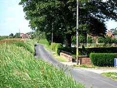
Skelton is a hamlet and former civil parish, now in the parish of Kilpin, in the East Riding of Yorkshire, England, and a linear settlement on the east bank of the River Ouse. It is situated about 2 miles (3.2 km) south-east of Howden and 19 miles (31 km) south-east from the county town of York. Skelton lies within the constituency of Haltemprice and Howden, an area placed as the 10th most affluent in the country in a Barclays Private Clients survey.[1] In 1931 the parish had a population of 258.[2]
| Skelton | |
|---|---|
 Southern End of Skelton | |
Location within the East Riding of Yorkshire | |
| OS grid reference | SE766256 |
| • London | 155 mi (249 km) S |
| Civil parish | |
| Unitary authority | |
| Ceremonial county | |
| Region | |
| Country | England |
| Sovereign state | United Kingdom |
| Post town | GOOLE |
| Postcode district | DN14 |
| Dialling code | 01430 |
| Police | Humberside |
| Fire | Humberside |
| Ambulance | Yorkshire |
| UK Parliament | |
Civil parish
editSkelton was formerly a township in the parish of Howden,[3] from 1866 Skelton was a civil parish in its own right, on 1 April 1935 the parish was abolished and merged with Kilpin, Eastrington and Howden.[4]
See also
edit- Goole railway swing bridge, also known as the Skelton viaduct
References
edit- Notes
- ^ "North tops 'real' rich league". BBC News. 14 May 2003. Retrieved 4 July 2014.
- ^ "Population statistics Skelton Tn/CP through time". A Vision of Britain through Time. Retrieved 10 August 2023.
- ^ "History of Skelton, in East Riding of Yorkshire and East Riding". A Vision of Britain through Time. Retrieved 10 August 2023.
- ^ "Relationships and changes Skelton Tn/CP through time". A Vision of Britain through Time. Retrieved 10 August 2023.
- Sources
- Gazetteer — A–Z of Towns Villages and Hamlets. East Riding of Yorkshire Council. 2006. p. 10.
External links
edit- Media related to Skelton at Wikimedia Commons
- Skelton in the Domesday Book
