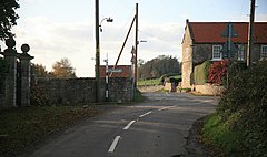
Slade Hooton /ˈsleɪd ˈhuːtən/ is a hamlet in the Metropolitan Borough of Rotherham, in South Yorkshire, England. Historically in the West Riding of Yorkshire, the hamlet was moved into South Yorkshire in April 1974.
| Slade Hooton | |
|---|---|
 Slade Hooton road junction | |
Location within South Yorkshire | |
| OS grid reference | SK523892 |
| Civil parish | |
| Metropolitan borough | |
| Metropolitan county | |
| Region | |
| Country | England |
| Sovereign state | United Kingdom |
| Post town | SHEFFIELD |
| Postcode district | S66 |
| Police | South Yorkshire |
| Fire | South Yorkshire |
| Ambulance | Yorkshire |
History
editSlade Hooton is recorded in the Domesday Book as Hotone, and having three carucates of land.[1][2] The name of the hamlet derives from Slæd and hõh-tũn, which means valley and farmstead on a spur of land. The Slade prefix is thought to be able to distinguish it from other Hooton's such as Hooton Levitt and Hooton Pagnell.[3][4]
A bus that runs three times a day, and connects Rotherham with Dinnington, stops at the south end of the hamlet.[5]
Governance
editHistorically, Slade Hooton was in the wapentake of Upper Strafforth, and the shire county of the West Riding of Yorkshire.[3] Since 1974, it has been in the Metropolitan county of South Yorkshire. It is now also in the Metropolitan Borough of Rotherham. The population of the village is recorded in the 2011 Census under the civil parish of Laughton en le Morthen.[6]
References
edit- ^ "[Slade] Hooton | Domesday Book". opendomesday.org. Retrieved 1 May 2022.
- ^ "History - LPC". laughtonparishcouncil.org.uk. Retrieved 1 May 2022.
- ^ a b Smith, A. H. (1961). The place-names of the West Riding of Yorkshire. Part 1 : Lower and Upper Strafforth and Staincross wapentakes. Cambridge: Cambridge University Press. p. 142. OCLC 928665241.
- ^ Hey, David (1979). The making of South Yorkshire. Ashbourne: Moorland Pub. p. 40. ISBN 0903485443.
- ^ "20 - Rotherham - Dinnington – TM Travel – bustimes.org". bustimes.org. Retrieved 1 May 2022.
- ^ UK Census (2011). "Local Area Report – Laughton-en-le-Morthen Parish (E04012114)". Nomis. Office for National Statistics. Retrieved 1 May 2022.
