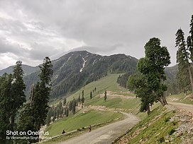
Sonbain Ashapati (or simply Sonbain) is a mountain massif in the Middle Himalayas of Jammu and Kashmir, India, southeast of the town of Bhaderwah near the border with Himachal Pradesh.[3] The Neeru river originates from the Ashapati glacier. The mountain massif lies on the inter-state border between Jammu and Kashmir and Himachal Pradesh, at the trisection of the Doda, Kathua and Chamba districts.
| Sonbain Ashapati | |
|---|---|
 Mt. Sonbain Ashapati, near Bhaderwah, District Doda, J&K, India. | |
| Highest point | |
| Elevation | 3,983 m (13,068 ft)[1] |
| Coordinates | 32°51′45″N 75°41′54″E / 32.862477°N 75.698274°E[2] |
| Geography | |
| Location | Doda district, Jammu and Kashmir, India |
| Parent range | Middle Himalayas |
Etymology
editThe Sonbain word is derived from two Bhaderwahi words, son meaning 'golden' and bain meaning 'spring'.[4]
Geography
editOn the Bhaderwah-Bani-Basholi road, Guldanda is a large ridge, from where the Sonbain Ashapati peak can be climbed. The Ashapati glacier, which gives birth to the Neeru river, is located to the left of this ridge.[5]
References
edit- ^ "JAMMU: UNKNOWN GEMS". Outlook (magazine). 4 July 2017. Retrieved 20 September 2022.
- ^ "Sonbain coordinates". Google Maps. Retrieved 20 September 2022.
- ^ "Ashapati Glacier (Sonbain) – The origin of river Neeru | Bhaderwah". Retrieved 20 September 2022.
- ^ Malik, Sadaket (20 October 2012). "Bhalessa heritage an eye opner".
- ^ Sadaq, Mohd (18 October 2021). "Hidden beauty of Bhaderwah Valley". The Northern Herald. Retrieved 20 September 2022.

