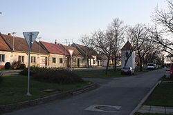
Sudoměřice is a municipality and village in Hodonín District in the South Moravian Region of the Czech Republic. It has about 1,300 inhabitants.
Sudoměřice | |
|---|---|
 Main street | |
| Coordinates: 48°52′2″N 17°15′24″E / 48.86722°N 17.25667°E | |
| Country | |
| Region | South Moravian |
| District | Hodonín |
| First mentioned | 1368 |
| Area | |
• Total | 9.33 km2 (3.60 sq mi) |
| Elevation | 182 m (597 ft) |
| Population (2024-01-01)[1] | |
• Total | 1,253 |
| • Density | 130/km2 (350/sq mi) |
| Time zone | UTC+1 (CET) |
| • Summer (DST) | UTC+2 (CEST) |
| Postal code | 696 66 |
| Website | www |
Etymology
editThe village was named after its founder Sudomír.[2]
Geography
editSudoměřice is located about 9 kilometres (6 mi) east of Hodonín and 58 km (36 mi) southeast of Brno, on the border with Slovakia. It lies mostly in a flat landscape of the Lower Morava Valley, only the eastern tip of the municipal territory extends into the White Carpathians mountain range. The highest point is at 265 m (869 ft) above sea level.
The Radějovka stream (here part of the Baťa Canal) flows through the municipality. The stream Sudoměřický potok flows along the Czech-Slovak border (and partly forms the border) until it joins the Radějovka. The eastern half of the municipal territory lies within the White Carpathians Protected Landscape Area.
History
editThe village was founded probably in 1262 by Sudomír Tvrdišovec, who was the chamberlain of King Ottokar II. The first written mention of Sudoměřice is from 1368, when it was bought by Beneš of Kravaře. The village suffered greatly from the invasions of troops from Hungary, the Thirty Years' War, and the invasions of Turks and Tatars in the second half of the 17th century.[2]
Demographics
edit
|
|
| ||||||||||||||||||||||||||||||||||||||||||||||||||||||
| Source: Censuses[3][4] | ||||||||||||||||||||||||||||||||||||||||||||||||||||||||
Economy
editSudoměřice is known for viticulture. The municipality lies in the Slovácká wine sub-region.
Transport
editIn Sudoměřice is the road border crossing Sudoměřice / Skalica with Slovakia. The I/55 road (the section from Hodonín to Uherské Hradiště) passes through the municipal territory.
Sudoměřice is located on the railway line Hodonín–Javorník.[5]
Sights
editThe main landmark of Sudoměřice is the Church of Christ the King. It was built in 1931–1933.[6]
A technical monument is the Sudoměřice coal tipper. The tipper was used to transfer lignite to ships on the Baťa Canal, which was brought by rail from a nearby mine. It dates from 1939. Today it serves as a lookout tower, and in its interior there is an exhibition about its function.[7]
References
edit- ^ "Population of Municipalities – 1 January 2024". Czech Statistical Office. 2024-05-17.
- ^ a b "Historie v letopočtech – obec Sudoměřice" (in Czech). Obec Sudoměřice. Retrieved 2024-04-02.
- ^ "Historický lexikon obcí České republiky 1869–2011" (in Czech). Czech Statistical Office. 2015-12-21.
- ^ "Population Census 2021: Population by sex". Public Database. Czech Statistical Office. 2021-03-27.
- ^ "Detail stanice Sudoměřice n.Moravou" (in Czech). České dráhy. Retrieved 2024-04-02.
- ^ "Kostel" (in Czech). Římskokatolická farnost Sudoměřice. Retrieved 2024-04-02.
- ^ "Technická památka Výklopník na Baťově kanále" (in Czech). CzechTourism. Retrieved 2022-06-29.


