You can help expand this article with text translated from the corresponding article in Chinese. (November 2016) Click [show] for important translation instructions.
|
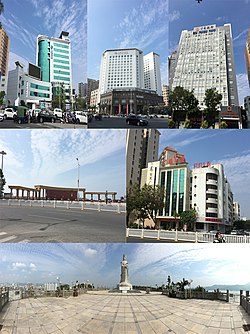
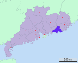
Shanwei (Chinese: 汕尾), or Swabue, or also commonly known as Hailufeng (Chinese: 海陆丰, portmanteau of Haifeng and Lufeng) is a prefecture-level city in eastern Guangdong province, People's Republic of China. It borders Jieyang to the east, Meizhou and Heyuan to the north, Huizhou to the west, and looks out to the South China Sea to the south. It lies approximately 120 kilometres (75 mi) east of Shenzhen and most of the locals speak the Haifeng dialect, a variety of Southern Min.
Shanwei
汕尾市 Swabue | |
|---|---|
 Shanwei | |
 | |
 Location of Shanwei in Guangdong | |
| Coordinates (Shanwei municipal government): 22°47′14″N 115°22′32″E / 22.7872°N 115.3756°E | |
| Country | People's Republic of China |
| Province | Guangdong |
| County-level divisions | 4 |
| Township divisions | 53 |
| Municipal seat | Chengqu |
| Government | |
| Area | |
| • Prefecture-level city | 4,861.79 km2 (1,877.15 sq mi) |
| Elevation | 8 m (26 ft) |
| Population (2010) | |
| • Prefecture-level city | 2,935,469 |
| • Density | 600/km2 (1,600/sq mi) |
| • Urban | 437,000 |
| GDP[1] | |
| • Prefecture-level city | CN¥ 128.8 billion US$ 20.0 billion |
| • Per capita | CN¥ 48,095 US$ 7,455 |
| Time zone | UTC+8 (China Standard) |
| Area code | 660 |
| ISO 3166 code | CN-GD-15 |
| Licence plate prefixes | 粤N |
| Major Nationalities | Han |
| Coastline (excluding islands) | 302 km (188 mi) |
| Shanwei | |||||||||||||||||||||||||
|---|---|---|---|---|---|---|---|---|---|---|---|---|---|---|---|---|---|---|---|---|---|---|---|---|---|
 "Shanwei", as written in Chinese | |||||||||||||||||||||||||
| Chinese | 汕尾 | ||||||||||||||||||||||||
| Hanyu Pinyin | Shànwěi | ||||||||||||||||||||||||
| Cantonese Yale | Saanméih | ||||||||||||||||||||||||
| Postal | Swabue | ||||||||||||||||||||||||
| Literal meaning | Tail or end of the fishing sandbar | ||||||||||||||||||||||||
| |||||||||||||||||||||||||
History
editShanwei City was established in 1988. It was politically administered as part of Huizhoufu (惠州府) by the Ming and Qing empires, Shanwei it gained its prefectural and administrative independence from Huizhou during the Nationalist period.
The dominant ethnic population is Hoklo who came as a result of the large decrease in population caused by warfare in the early Qing dynasty in what is now Shanwei.
Administration
editThe prefecture-level city of Shanwei administers 4 county-level divisions, including 1 district, 1 county-level city and 2 counties.
| Map | |||||
|---|---|---|---|---|---|
| Name | Simplified Chinese | Hanyu Pinyin | Population (2010 census) |
Area (km2) |
Density (/km2) |
| Chengqu District | 城区 | Chéng Qū | 491,766 | 421 | 1,168 |
| Haifeng County | 海丰县 | Hǎifēng Xiàn | 804,107 | 1,750 | 459 |
| Luhe County | 陆河县 | Lùhé Xiàn | 314,153 | 986 | 318 |
| Lufeng City | 陆丰市 | Lùfēng Shì | 1,688,536 | 1,671 | 940 |
| Shenshan Special Cooperation Zone |
深汕特别合作区 | Shēnshàn Tèbié Hézuò Qū |
|||
These are further divided into 53 township-level divisions, including 40 towns, 10 townships and 3 subdistricts.
Geography and climate
editShanwei has a monsoon-influenced humid subtropical climate (Köppen Cwa), with short, mild to warm winters, and long, hot, humid summers. Winter begins sunny and dry but becomes progressively wetter and cloudier. Spring is generally overcast, while summer brings the heaviest rains of the year though is much sunnier; there are 10.3 days with 50 mm (1.97 in) or more rainfall. Autumn is sunny and dry. The monthly 24-hour average temperature ranges from 15.2 °C (59.4 °F) in January to 28.3 °C (82.9 °F) in July, and the annual mean is 22.60 °C (72.7 °F). The annual rainfall is around 1,891 mm (74 in), about two-thirds of which occurs from May to August. With monthly percent possible sunshine ranging from 26% in March to 57% in October, the city receives 1,925 hours of bright sunshine annually.
| Climate data for Shanwei (1991–2020 normals, extremes 1971–2010) | |||||||||||||
|---|---|---|---|---|---|---|---|---|---|---|---|---|---|
| Month | Jan | Feb | Mar | Apr | May | Jun | Jul | Aug | Sep | Oct | Nov | Dec | Year |
| Record high °C (°F) | 27.4 (81.3) |
28.4 (83.1) |
30.0 (86.0) |
32.1 (89.8) |
32.2 (90.0) |
34.5 (94.1) |
38.0 (100.4) |
35.2 (95.4) |
35.7 (96.3) |
34.7 (94.5) |
33.2 (91.8) |
29.4 (84.9) |
38.0 (100.4) |
| Mean daily maximum °C (°F) | 19.5 (67.1) |
20.0 (68.0) |
22.1 (71.8) |
25.3 (77.5) |
28.4 (83.1) |
30.1 (86.2) |
31.2 (88.2) |
31.3 (88.3) |
31.1 (88.0) |
28.9 (84.0) |
25.6 (78.1) |
21.4 (70.5) |
26.2 (79.2) |
| Daily mean °C (°F) | 15.3 (59.5) |
16.1 (61.0) |
18.6 (65.5) |
22.1 (71.8) |
25.5 (77.9) |
27.6 (81.7) |
28.5 (83.3) |
28.4 (83.1) |
27.6 (81.7) |
25.0 (77.0) |
21.4 (70.5) |
17.1 (62.8) |
22.8 (73.0) |
| Mean daily minimum °C (°F) | 12.4 (54.3) |
13.5 (56.3) |
16.0 (60.8) |
19.8 (67.6) |
23.2 (73.8) |
25.5 (77.9) |
26.1 (79.0) |
25.9 (78.6) |
24.9 (76.8) |
22.1 (71.8) |
18.3 (64.9) |
14.1 (57.4) |
20.2 (68.3) |
| Record low °C (°F) | 3.0 (37.4) |
4.5 (40.1) |
7.0 (44.6) |
9.6 (49.3) |
15.6 (60.1) |
19.5 (67.1) |
21.7 (71.1) |
21.5 (70.7) |
18.2 (64.8) |
13.9 (57.0) |
8.4 (47.1) |
2.1 (35.8) |
2.1 (35.8) |
| Average precipitation mm (inches) | 33.1 (1.30) |
38.8 (1.53) |
71.4 (2.81) |
143.0 (5.63) |
264.3 (10.41) |
443.3 (17.45) |
300.3 (11.82) |
343.4 (13.52) |
199.3 (7.85) |
43.2 (1.70) |
28.1 (1.11) |
24.1 (0.95) |
1,932.3 (76.08) |
| Average precipitation days (≥ 0.1 mm) | 4.9 | 7.2 | 10.1 | 11.5 | 13.5 | 17.4 | 16.9 | 15.2 | 10.8 | 3.9 | 4.0 | 4.9 | 120.3 |
| Average relative humidity (%) | 71 | 76 | 78 | 82 | 83 | 85 | 84 | 83 | 77 | 70 | 70 | 67 | 77 |
| Mean monthly sunshine hours | 153.2 | 114.4 | 104.7 | 118.2 | 149.2 | 166.0 | 224.3 | 201.6 | 198.0 | 214.5 | 183.8 | 167.6 | 1,995.5 |
| Percent possible sunshine | 45 | 36 | 28 | 31 | 36 | 41 | 54 | 51 | 54 | 60 | 56 | 50 | 45 |
| Source: China Meteorological Administration[2][3][4] | |||||||||||||
Transportation
editEconomy
editTies with Shenzhen
editAccording to a December 2011 report, officials from Shenzhen considered Shanwei as one of the major destinations to which air-polluting industries should be relocated from Shenzhen. According to the mayor of Shenzhen, some 4000 Shenzhen factories should be moved to an industrial park in Shanwei.[5]
Crops
editFarming is a large part of Shanwei's economy, thanks to its relatively warm climate. Many different types of crops are planted, rice, sesame, sweet potatoes, corn, bananas, just to name a few. 29 families and 42 species of plants are planted in total, on its 96.6 thousand hectares of farmland. Together with the timber and fish industry, the agriculture industry makes 25099 million Chinese yuan yearly.[6]
Fisheries
editShenwei have a rich and diverse sea ecosystem, it's a famous fishing ground in Guangdong. With a vast amount of fish, shrimp, crab, shellfish, and seaweed found, the fishing industry there has been thriving for centuries. Currently 25099 million Chinese yuan are earned from the fishing industry, including other harvest industries such as agriculture each year.[7]
Tourism
editWith its long, interesting coastline and unique customs, Shanwei has a great potential for tourism. The few major tourist points in Shanwei are Lufeng Jieshi Xuanwu Mountain Tourist Area, Shanwei Fengshan Ancestral Temple Tourist Area, Red Bay Tourist Area, Haifeng Lotus Mountain Resort, Tongdingshan Tourist Area, Haifeng Red Palace Red Square Former Residence, Peng Pai Martyr's Former Residence, Shuide Mountain Tourist Resort, Luhe Luodong Shiwai Meiyuan Tourist Area, Lufeng Fushan Mazu Tourist Area, Lufeng Jinxiang Beach Seascape Area, Lufeng Qingyun Mountain, Luhe God Elephant Mountain Park, Luhe Red Spine Forest Ecological Park. It's also one of the 13 communist revolution starting points in China, which can be used as a selling point.[8]
Recent history
editOn the night of December 6, 2005, a protest had broken out for land confiscated by the government. To calm the protest, armed police were sent to the village of Dongzhou after the aggressive villagers attacked the unarmed police.[9][10] It was reported by the Chinese government that, three people were found dead after the protest. However, the number was doubted by media to be between 20 and 40.[11]
In 2011, a conflict between the residents of the Wukan village (in Shanwei's Lufeng county-level city, on the Jieshi Bay some 30 km (19 mi) east of Shanwei city center) attracted world media's attention.
Language
editGenerally used is Haklau Min which is similar to Hokkien and Teochew, belonging to the Southern Min division of Min Chinese. Haifeng, Lufeng and the urban area have basically the same accent. Most parts of the rural Luhe county formerly part of Lufeng use the rural Hakka Chinese language belonging to the Xinhui subdialect of the Yuetai dialect.
As Shanwei is near the Pearl River Delta and Hong Kong, together with the impact of television programs from Hong Kong and population movements within Guangdong province, many local residents, especially the younger generation, have communication skills in Cantonese.
References
edit- ^ 广东省统计局、国家统计局广东调查总队 (August 2016). 《广东统计年鉴-2016》. 中国统计出版社. ISBN 978-7-5037-7837-7. Archived from the original on 2017-12-22.
- ^ 中国气象数据网 – WeatherBk Data (in Simplified Chinese). China Meteorological Administration. Retrieved 28 May 2023.
- ^ "Experience Template" 中国气象数据网 (in Simplified Chinese). China Meteorological Administration. Retrieved 28 May 2023.
- ^ "数据集检索" 中国地面国际交换站气候标准值月值数据集(1971-2000年). China Meteorological Administration. Archived from the original on 2013-09-21. Retrieved 2010-05-25.
- ^ "Beijing, Shenzhen to Close Polluting Plants by 2016, Xinhua, 2011-11-27". Bjreview.com.cn. Retrieved 2013-07-28.
- ^ "汕尾市 广东省情网" (in Chinese). 广东省人民政府地方志办公室. Feb 19, 2021. Archived from the original on 2021-06-02. Retrieved 2021-05-31.
- ^ "汕尾市 广东省情网" (in Chinese). 广东省人民政府地方志办公室. Feb 19, 2021. Archived from the original on 2021-06-02. Retrieved 2021-05-31.
- ^ "汕尾市 广东省情网" (in Chinese). 广东省人民政府地方志办公室. Feb 19, 2021. Archived from the original on 2021-06-02. Retrieved 2021-05-31.
- ^ "Protest Planned over Land Dispute in China". NPR. 2005-12-16. Retrieved 2013-07-28.
- ^ "Xinhua - English". news.xinhuanet.com. Archived from the original on 2008-03-26. Retrieved 2022-08-09.
- ^ French, Howard W. (December 17, 2005). "Chinese Pressing to Keep Village Silent on Clash - International Herald Tribune". The New York Times. Retrieved 2023-01-06.
External links
edit- Official website (in Simplified Chinese)
