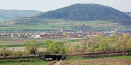
Târnava (German: Grossprobtsdorf; Hungarian: Nagyekemező) is a commune located in Sibiu County, Transylvania, Romania. It is composed of two villages, Colonia Târnava (Nagyekemezőtelep) and Târnava (formerly Proștea Mare). The route of the Via Transilvanica long-distance trail passes through the village of Târnava.[2]
Târnava | |
|---|---|
 Panoramic view of Târnava commune | |
 Location in Sibiu County | |
| Coordinates: 46°08′28″N 24°17′35″E / 46.141°N 24.293°E | |
| Country | Romania |
| County | Sibiu |
| Government | |
| • Mayor (2020–2024) | Norbert-Jácint Pleiner (PSD) |
| Area | 29.38 km2 (11.34 sq mi) |
| Elevation | 300 m (1,000 ft) |
| Highest elevation | 600 m (2,000 ft) |
| Population (2021-12-01)[1] | 3,007 |
| • Density | 100/km2 (270/sq mi) |
| Time zone | EET/EEST (UTC+2/+3) |
| Postal code | 557275 |
| Vehicle reg. | SB |
| Website | www |
Geography
editThe commune is situated on the Transylvanian Plateau. It lies on the banks of the river Târnava Mare, in the northern part of the county, right in between the city of Mediaș and the town of Copșa Mică.
Demographics
editAt the 2011 census, 64.6% of inhabitants were Romanians, 31.5% Roma, 2.7% Hungarians and 1.1% Germans.
Transport
editTârnava is crossed by National Road DN14, which connects the county seat, Sibiu, to Sighișoara in Mureș County. There is also a train station that serves Line 300 of the CFR network, which connects Bucharest with the Hungarian border near Oradea.
References
edit- ^ "Populaţia rezidentă după grupa de vârstă, pe județe și municipii, orașe, comune, la 1 decembrie 2021" (XLS). National Institute of Statistics.
- ^ "Terra Saxonum | Via Transilvanica". www.viatransilvanica.com (in Romanian). Retrieved 2023-08-14.

