| This is the template sandbox page for Template:Infobox rockunit (diff). See also the companion subpage for test cases. |
| This template is used on approximately 6,400 pages and changes may be widely noticed. Test changes in the template's /sandbox or /testcases subpages, or in your own user subpage. Consider discussing changes on the talk page before implementing them. |
| This template uses Lua: |
Usage
editSpecify parameters as instructed below.
- {{{name}}} will default to the name of the page if unspecified.
- {{{period}}} should specify the main period in which the unit lies; if this value is a unlinked standard period name, this value will colour the taxobox according to the international standard period colours.
- If {{{age}}} is unspecified, then the value of {{{period}}} will also be used to illustrate the unit's stratigraphic range (see Template:Period color).
- When specified, the mark up text for {{{age}}} appears for the unit's stratigraphic range, and if includes Template:fossilrange or Template:Geological range may illustrate the unit's temporal range (see examples).
{{Infobox rockunit
| name           =
| period         =
| age            =
| image          =
| imagesize      =
| caption        =
| type           = [[Geological formation]]
| prilithology   =
| otherlithology =
| unitof         =
| subunits       =
| underlies      =
| overlies       =
| thickness      = up to {{Convert||ft|m|-1}}
| area           =
| map            =
| map_caption    =
<!----Location---->
| location       =
| coordinates    = {{Coord||N||W|display=inline}}
| region         =
| country        =
| extent         = {{Convert||mi|km}}
<!--Type section--->
| namedfor       = <!--Usually a nearby town-->
| namedby        = <!--Author of defining paper-->
| year_ts        = <!--Year of definition-->
| location_ts    = <!--Place,mountain,...-->
| coordinates_ts = {{Coord||N||W|display=inline}}<!--Geographic coordinates-->
| paleocoordinates_ts = {{Coord||N||W|display=inline}}<!--Paleocoordinates-->
| region_ts      = <!--Region of type section-->
| country_ts     = <!--Country of type section-->
| thickness_ts   = <!--Thickness at type section-->
}}
Usage examples
edit| Marcellus Formation | |
|---|---|
| Stratigraphic range: Mid Devonian, ~ | |
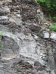
 Marcellus shale exposure above Marcellus, New York | |
| Type | Geological formation |
| Unit of | Hamilton Group |
| Sub-units | {list of sub-units} |
| Underlies | Mahantango Formation |
| Overlies | Onondaga Formation |
| Area | {area} |
| Thickness | up to 900 feet (270 m) |
| Lithology | |
| Primary | Shale |
| Other | Slate, Limestone, Sandstone |
| Location | |
| Coordinates | 42°59′N 76°20′W / 42.99°N 76.34°W |
| Region | Appalachian Basin of eastern North America |
| Country | {country} |
| Extent | 600 miles (970 km) |
| Type section | |
| Named for | Marcellus, New York |
| Named by | James Hall |
| Year defined | 1839 |
| Country | United States |
 Extent of the Marcellus Formation | |
{{Infobox rockunit
 | name = Marcellus Formation
 | age = Mid Devonian, ~{{fossil range|395|390}}
 | period = Mid Devonian
 | image = MarcellusShaleBank1.jpg
 | imagesize = 180px
 | type = [[Geological formation]]
 | prilithology = [[Shale]]
 | otherlithology = [[Slate]], [[Limestone]], [[Sandstone]]
 | region = [[Appalachian Basin]] of
             <br><eastern North America
 | country = {country}
 | coordinates = {{coord|42.99|N|76.34|W}}
 | caption = Marcellus shale exposure
             above Marcellus, New York
 | unitof = [[Hamilton Group]]
 | subunits = {list of sub-units}
 | underlies = [[Mahantango Formation]]
 | overlies = [[Onondaga Formation]]
 | thickness = up to {{convert|900|ft|m|-1}}
 | extent = {{convert|600|mi|km}}
 | area = {area}
 | map = Little Belts.PNG
 | map_caption = Extent of the Marcellus Formation

| namedfor       = [[Marcellus (village), New York|Marcellus, New York]]
| namedby        = [[James Hall (paleontologist)|James Hall]]
| year_ts        = 1839

| location_ts    = <!--Place,mountain,...-->
| coordinates_ts = {{Coord||N||W|display=inline}}<!--Geographic coordinates-->

| region_ts      = <!--Region of type section-->
| country_ts     = United States
| thickness_ts   = <!--Thickness at type section-->
}}
| Cretaceous chalk | |
|---|---|
Stratigraphic range: | |
| Lithology | |
| Primary | Chalk |
| Location | |
| Country | U.K. |
{{infobox rockunit
 | name = Cretaceous chalk
 | period = Late Cretaceous
 | prilithology = Chalk
 | country = U.K.
}}
| Dakota Formation / Group | |
|---|---|
| Stratigraphic range: Albian-Cenomanian, around |
Because the Dakota straddles the Albian-Cenomanian (early/late) boundary, the Cretaceous is used for the colour:
{{Infobox rockunit
 | name           = Dakota Formation / Group
 | age            = <br/>[[Albian]]-[[Cenomanian]],<br/>around {{fossilrange|100|95}}
 | period         = Cretaceous
}}
Tracking category
editTemplate Data
editThis is the TemplateData for this template used by TemplateWizard, VisualEditor and other tools. See a monthly parameter usage report for Template:Infobox rockunit in articles based on its TemplateData.
TemplateData for Infobox rockunit
No description.
| Parameter | Description | Type | Status | |
|---|---|---|---|---|
| name | name | no description | Unknown | optional |
| period | period | no description | Unknown | optional |
| age | age | no description | Unknown | optional |