The Pointers is a pair of rocks off the northwest coast of Rugged Island, lying between Eddystone Rocks and Start Point, Livingston Island in the South Shetland Islands, Antarctica.
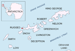
 Location of Rugged Island in the South Shetland Islands | |
| Geography | |
|---|---|
| Location | Antarctica |
| Coordinates | 62°35′21.1″S 61°19′15.3″W / 62.589194°S 61.320917°W |
| Archipelago | South Shetland Islands |
| Administration | |
| Administered under the Antarctic Treaty System | |
| Demographics | |
| Population | uninhabited |
The rocks were known to 19th century sealers who named them descriptively as a navigational mark and hazard near the entrance to New Plymouth harbour.
Location
editThe rocks are centred at 62°35′21.1″S 61°19′15.3″W / 62.589194°S 61.320917°W which is 5.39 km (3.35 mi) west of Start Point, Livingston Island, 2.92 km (1.81 mi) north-northwest of Cape Sheffield and 3.54 km (2.20 mi) east-northeast of Eddystone Rocks (British mapping in 1968, Chilean in 1971, Argentine in 1980, and Bulgarian in 2009).
See also
editReferences
editThis article incorporates public domain material from "The Pointers". Geographic Names Information System. United States Geological Survey.
External links
edit62°36′S 61°19′W / 62.600°S 61.317°W

