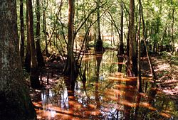
The Tickfaw River /ˈtɪkfɔː/ runs 113 miles (182 km)[1] from Amite County in southwest Mississippi to Livingston Parish in southeast Louisiana. Its mouth opens into Lake Maurepas, which conjoins with Lake Pontchartrain.[2]
| Tickfaw River | |
|---|---|
 | |
 Tickfaw River | |
| Location | |
| Country | United States |
| States | |
| County/Parish | |
| Physical characteristics | |
| Source | West Branch Tickfaw River |
| • location | Amite County, Mississippi |
| • coordinates | 31°03′16″N 90°37′38″W / 31.05444°N 90.62722°W |
| • elevation | 279 ft (85 m) |
| Mouth | Lake Maurepas |
• location | Killian, Livingston Parish, Louisiana |
• coordinates | 30°20′36″N 90°28′27″W / 30.34333°N 90.47417°W |
• elevation | −3 ft (−0.91 m) |
| Length | 113 mi (182 km) |
| Basin features | |
| Cities | |
| Tributaries | |
| • left |
|
The name Tickfaw (Tiak foha) is thought to be derived from the Choctaw phrase meaning "pine rest" or "Rest Among the Pines".[3][4] More recent analysis however has determined the name to be derived from shortening and alteration of Pawticfaw meaning "place where wild animals have shed their hair".[5] Alternate/historical names and spellings:[6]
- Rio De San Vicente
- Rio De Tickfaw
- Rio Go Tickfoha
- Rivière Ticfoha
- Ticfaw River
- Tickfah River
- Tickfaw Creek
See also
editReferences
edit- ^ U.S. Geological Survey. National Hydrography Dataset high-resolution flowline data. The National Map, accessed June 20, 2011
- ^ The Columbia Gazetteer of North America. 2000.
- ^ Sandy Nestor (24 May 2012). Indian Placenames in America. McFarland. p. 1. ISBN 978-0-7864-9339-5.
- ^ William A. Read (30 October 1984). Indian Place Names in Alabama. University of Alabama Press. p. 68. ISBN 978-0-8173-0231-3.
- ^ Baca, Keith A. (2007). Native American Place Names in Mississippi. University Press of Mississippi. p. 111. ISBN 978-1-60473-483-6.
- ^ USGS Geographic Names Information System - Tickfaw River
External links
edit- USGS Geographic Names Information System - West Branch Tickfaw River
- US EPA National Assessment Database
- Army Corps of Engineers Map of the Tickfaw River
- US Army Corps of Engineers River and Harbor Act Projects - New Orleans District