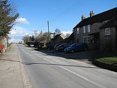
Tunstall is a village and civil parish in the Richmondshire district of North Yorkshire, England about 2 miles (3.2 km) west of Catterick Village and the A1(M) motorway. It had a population of 253 increasing to 271 at the 2011 census.[1]
| Tunstall | |
|---|---|
 Tunstall | |
Location within North Yorkshire | |
| Population | 271 (2011 census) |
| Unitary authority | |
| Ceremonial county | |
| Region | |
| Country | England |
| Sovereign state | United Kingdom |
| Post town | Richmond |
| Postcode district | DL10 |
| Police | North Yorkshire |
| Fire | North Yorkshire |
| Ambulance | Yorkshire |
History
editTunstall was mentioned in the Domesday Book in 1096 as being in the hundred of "Land of Count Alan" and the county of Yorkshire, the population was estimated at 14.8 households.
In 1870-72 John Marius Wilson's Imperial Gazetteer of England and Wales described Tunstall as:
"a township-chapelry in Catterick parish, N. R. Yorkshire; 3 miles S of Catterick-Bridge r. station. Post town, Catterick. Acres, 1,262. Real property, £2,139. Pop., 293. Houses, 66. The living is annexed to Catterick. The church was built in 1847. There are a Wesleyan chapel and a slightly endowed school."
Governance
editThe village lies within the Richmond (Yorks) parliamentary constituency, which is under the control of the Conservative Party. The current Member of Parliament, since the 2015 general election, is Rishi Sunak. Tunstall also lies within the Scotton ward of Richmondshire District Council.[2]
Community and culture
editThe church was built in 1846 as a chapel of ease to St Michael and All Angels in neighbouring Hudswell.[3][4] The building was grade II listed in 1969.[5] Tunstall has one public house, The Bay Horse, which is tied to the Yorkshire-based brewer Samuel Smith.[6]
References
edit- ^ UK Census (2011). "Local Area Report – Tunstall Parish (1170217196)". Nomis. Office for National Statistics. Retrieved 15 January 2019.
- ^ "Scotton ward map" (PDF). Richmondshire District Council. Retrieved 26 May 2020.
- ^ "Tunstall: Holy Trinity". achurchnearyou.com. Retrieved 15 January 2019.
- ^ "Parishes: Catterick". british-history.ac.uk/. Retrieved 15 January 2019.
- ^ Historic England. "Church of the Holy Trinity (Grade II) (1157457)". National Heritage List for England. Retrieved 15 January 2019.
- ^ "Bay Horse, Tunstall". whatpub.com. Retrieved 24 July 2020.
External links
editMedia related to Tunstall, North Yorkshire at Wikimedia Commons
