Spain established its colony of Santa Fe de Nuevo Méjico (New Mexico) on 1598-07-12. Spain claimed a huge, but unspecified, region within about one hundred leagues (approximately 345 miles or 556 kilometers) of the upper Rio Grande as part of this colony. This claim encompassed all of the present U.S. states of New Mexico and Colorado and adjacent areas.
A century later, France established its colony of la Louisiane on 1699-02-13. France claimed the entire drainage basin of the Mississippi River, although France had no idea that the basin was the Earth's second longest river system.
Spain assumed administration of la Louisiane as a result of the Treaty of Paris signed on 1763-02-10. Spain renamed the colony la Louisiana, but the colony retained its essential French character.

Thirteen British colonies declared their independence from the United Kingdom as the United States of America on 1776-07-04.

France reacquired la Louisiane as a result of the Treaty of San Ildefonso signed in secrecy on 1800-10-01, but France was ill equipped to resume control of its colony.

The United States acquired a claim to the entire Mississippi River drainage basin with its Louisiana Purchase from France on 1803-12-20. This claim conflicted with Spain's claim to the southern Rocky Mountain region.

In 1806 and 1807, a U.S. Army surveillance party under the command of Captain Zebulon Pike reconnoitered the disputed region between the Louisiana Purchase and the Spanish Province of New Mexico to assess Spain's military strength and intentions in the region.

México declared its independence on 1810-09-16, but Spain continued to assert its control. The United States ceded the region south and west of the Arkansas River to Spain (in exchange for Florida) with the Adams-Onís Treaty on 1821-02-22.

Six months later on 1821-08-24, Spain recognized the independence of México.

The Republic of Texas declared its independence from México on 1836-03-02. By virtue of the Treaties of Velasco signed on 1836-05-14, the Republic of Texas claimed all land between the Rio Grande and the Arkansas River, including a strip from the headwaters of the two rivers extending north to the 42nd parallel north, but Texas made no attempt to occupy this western region. México staunchly refuted this claim and insisted that the Rio Nueces was the legitimate border between the two nations.

The United States admitted Texas to the Union on 1845-12-29, and assumed the disputed territorial claims of the Republic of Texas. U.S. President James K. Polk sent U.S. troops to secure the disputed region between the Rio Nueces and the Rio Grande. The Mexican-American War ensued.

The United States secured the disputed Texas claims and acquired the remaining northern territory of Mexico at the conclusion of the Mexican-American War with the Treaty of Guadalupe Hidalgo on 1848-05-30.

The Compromise of 1850 set the northern and western boundaries of the State of Texas and organized the Territory of New Mexico and the Territory of Utah on 1850-09-09. On 1851-04-09, Hispanic settlers from Taos, New Mexico, settled San Luis, then in the new Territory of New Mexico, but now the oldest town in Colorado.

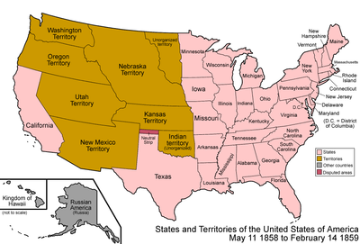
The Kansas-Nebraska Act organized the Territory of Kansas and the Territory of Nebraska on 1854-05-30.

Substantial quantities of gold were discovered along the South Platte River in western Kansas Territory in 1858, precipitating the Pike's Peak Gold Rush.

The de facto but extralegal Territory of Jefferson governed the region from 1859-10-24, until 1861.

The anti-slavery Republican Party took control of the U.S. Congress following the U.S. election of 1860. Six slave states seceded from the United States as civil war loomed. The eastern portion of the Territory of Kansas was admitted to the Union as the free State of Kansas on 1861-01-29. This left the western portion of the former Kansas Territory unorganized.

Ten days later on 1861-02-08, the six slave states of South Carolina, Mississippi, Florida, Alabama, Georgia, and Louisiana formed the Confederate States of America.

Twenty days later on 1861-02-28, outgoing U.S. President James Buchanan signed the Organic Act for the free Territory of Colorado.[1] (No substantive changes have been made to the boundaries of Colorado since this act.) Abraham Lincoln assumed the U.S. Presidency four days later on 1861-03-04, and American Civil War soon commenced. The Territory of Jefferson dissolved shortly after Governor William Gilpin of the new Colorado Territory arrived.

On 1876-08-01, 28 days after the Centennial of the United States, U.S. President Ulysses Grant issued a Presidential Proclamation declaring that the Territory of Colorado had met the criteria set by the U.S. Congress and was admitted to the Union as the State of Colorado, the 38th U.S. State.

The State of Colorado and the United States of America today.
See also
edit| History of geography |
|---|
- Territory of New Mexico
- Territory of Utah
- Territory of Kansas
- Territory of Nebraska
- Territory of Jefferson
- Territory of Colorado
- State of Colorado
- History of Colorado
- Geography of Colorado
- Territorial evolution of the United States
References
edit- ^ "An Act to provide a temporary Government for the Territory of Colorado" (PDF). Thirty-sixth United States Congress. 1861-02-28. Retrieved 2007-06-04.
{{cite web}}: Check date values in:|date=(help)
Category:Geography of Colorado Category:History of Colorado Colorado Category:Boundaries of U.S. states