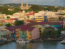
Parish of Saint John[1] | |
|---|---|
 Saint John's, the capital of Saint John Parish. | |
![Location of Parish of Saint John[1]](http://upload.wikimedia.org/wikipedia/commons/thumb/b/bd/Saint_John_in_Antigua_and_Barbuda_%28cropped%29.svg/250px-Saint_John_in_Antigua_and_Barbuda_%28cropped%29.svg.png) | |
| Country | Antigua and Barbuda |
| Island | Antigua |
| Established | 11 January 1692 |
| Capital | St. John's |
| Government | |
| • Magistrate | Carden Conliffe Clarke |
| Area | |
| • Total | 74 km2 (28.5 sq mi) |
| Population (2018 estimate)[2] | |
| • Total | 56,736 |
| • Density | 770/km2 (2,000/sq mi) |
| Demonym | Saint Johnstonian |
| Time zone | UTC-4 (AST) |
Saint John, officially the Parish of Saint John, is a civil parish of Antigua and Barbuda, on the northwestern portion of Antigua island. Its capital is the city of St. John's. Saint John borders Saint Mary, Saint Peter, Saint George, and Saint Paul. Saint John faces the Caribbean Sea. Saint John is surrounded by some of Antigua's most premier beaches. Saint John had a population of 56,736 in a 2018 estimate, making it home to the majority of the population in Antigua and Barbuda.[3]
While Saint John is a civil administrative division, the Anglican parish church is located in the city of St. John's. Saint John is mostly centered around the St. John's urban area and the northern tourist area, but is also home to more rural areas in the southern salient and in the Five Islands-Yeptons area. Due to Saint John holding the majority of the population of Antigua and Barbuda, it is home to hundreds of populated locations some of which are vastly different from another. The island of Redonda is also under the administration of Saint John.[4]
Saint John was formed on 11 January 1692 alongside four other parishes, for the original purpose of serving the parish church. Outside of the city, most of the rural areas of the parish were originally used as sugar mills. Many remnants of the parish's past are still visible in the modern day, such as with the Cedar Valley Plantation,[5] or the Weatherill's plantation.[6]
History
editGeography
editDemographics
editPolitics and government
editEconomy
editSee also
editReferences
edit- ^ http://laws.gov.ag/wp-content/uploads/2018/08/cap-304.pdf [bare URL PDF]
- ^ "Antigua and Barbuda 2018 Labour Force Survey Report" (PDF). Antigua & Barbuda Statistics Division (statistics.gov.ag). October 2020. Retrieved 2022-09-03.
Table 6.2.1
- ^ "Antigua and Barbuda 2018 Labour Force Survey Report" (PDF). Antigua & Barbuda Statistics Division (statistics.gov.ag). October 2020. Retrieved 2022-09-03.
Table 6.2.1
- ^ "Chapter 373: The Redonda Annexation Act". Laws of Antigua & Barbuda (PDF). Antigua & Barbuda Ministry of Legal Affairs (laws.gov.ag).
- ^ "Cedar Valley Plantation – Antigua Sugar Mills". Retrieved 2023-09-23.
- ^ "Weatherill – Antigua Sugar Mills". Retrieved 2023-09-23.