


Geospatial Summary of Geographical Features on the Juneau Icefield
edit- The areal size of the Juneau Icefield is 1,744 sq mi (4,517 km2)[W 1].
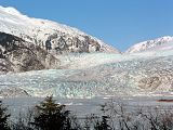
- The largest glacier by area at 874 km2 (337 sq mi) is the Taku Glacier[W 2], while the Meade Glacier is 2nd at 748 km2 (289 sq mi)[W 3].
- There are more than 150 glaciers[W 4] within the boundaries of the Juneau Icefield
- There are more than 240 peaks [W 5] over 2,000 m (6,562 ft) within the general area of the Juneau Icefield, of which only <20 have been climbed.
- Taku Glacier is the longest glacier at 60 km (37 mi) within the Juneau Icefield.
- There are more than 80[W 6] Hydrologic Units within the Juneau Icefield, of which the Field Glacier is the largest Level-10 Basin at 1,062.88 km2 (410 sq mi)[W 7].
- The Taku Glacier is the thickest 4,846 ft (1,477 m) at an elevation of 800 m (2,625 ft) of all measured glaciers in Alaska[JG 1]. The base of the glacier is therefore 677 m (2,221 ft) below sea level.
- The Gilkey Trench(Lower Gilkey Glacier) contains three(3) nunataks which are the largest within the Juneau Icefield at 36.6 km2 (14 sq mi), 38.0 km2 (15 sq mi) and 42.4 km2 (16 sq mi).
- There are four(4) main hydrologic outlets to the Juneau Icefield: Taku River, Berners Bay, Katzehin River and Atlin Lake (to the Yukon River)
- During the time of maximal glaciation(Neoglacial Period) the Gilkey and Field glaciers intersected and possibly formed a tidewater glacier that formed Berners Bay, Juneau, Alaska 58°45′44″N 134°58′47″W / 58.76231°N 134.97981°W
- The Juneau Icefield is Bi-Modal, in that the Neve Area is divided into two(2) nodes (Mount Poletica) and Mount Nesselrode.
Mount Poletica is the North Apex Point . All Hydrologic Basins intersect at the point. 190103030000, 190103030703, 190103010205 and 190701010000
- The Lemon Creek, Ptarmigan, Sloko and Nakima Glaciers are not considered part of the Juneau Icefield because they do not satisfy the Common Source requirement.
Further Investigation
editThere are several areas that indicate that further investigation may reveal more details(however slight) as to the systemic structure of the Juneau Icefield.
- Possible separate glacier near the Field Glacier Neve Zone. Would require ice-penetrating radar (IPR) profiles to determine is a shallow ridge exists and glacial flow analysis by GPS profiling of the area to determine if the flow reflects the hypothetical flow of a separate glacier.
- Vertical face
Definition of Terms/Terminology
editIn this article glaciated/glaciation areas means the glacier area and the adjacent landmass up to the Hydrologic Unit Boundary line, while glacier area refers to the actual area of snow/ice which comprises the glacier.
Glacial Icefield Basics
editThe characteristic definitions of a Glacial Icefield are:
- Extensive area of multiple contiguously interconnected Valley Glaciers having a common source [citation needed]
- Glacier flow is influenced by the underlying topography.
- Geographical area more than 500 km2 (193 sq mi) [citation needed]
- Geographical area less than 50,000 km2 (19,305 sq mi) [citation needed]
- Physically constrained by local/regional topography
- Unlike an Ice-cap, an Icefield lacks a domed form.
Spacial determination of the Icefield Boundary
- Geological/Geographical features(Nunataks) surrounded(completely) by the perennial snow/ice area are considered to be part of the Icefield.
- If a glacier has tributaries that are not connected to the "Common Source", but the main glacier is, the tributaries are still considered part of the Icefield.
Large Icefields in the Western Hemisphere
edit
Note: No detailed measurements have been found to support many of the reported areal sizes of these Icefields.
Notes
- ^ Common Source Location
- ^ GNIS does not contain an entry for the Stikine Icefield
- ^ The Harding Icefield was split into North and South to adhere to the Common Source rule of icefield definition. The separation line is Bradley Lake59°44′53″N 150°47′36″W / 59.74794°N 150.79333°W to the north, Nuka River59°38′37″N 150°39′49″W / 59.64361°N 150.66372°W traversing Northwest to Southeast to Beauty Bay59°32′11″N 150°38′01″W / 59.53630°N 150.63351°W in the South. This division is identical to why the Taku River divides the Juneau Icefield from the Stikine Icefield.
- ^ The Sargent Icefield was split into North and South to adhere to the Common Source rule of icefield definition. The boundary line is from Kings Bay60°29′00″N 148°38′13″W / 60.48340°N 148.63701°W in the Northwest following the Nellie Juan River60°21′14″N 148°53′15″W / 60.35392°N 148.88749°W in a Southwest direction to Nellie Juan Lake60°13′53″N 149°03′27″W / 60.23146°N 149.05741°W to Day Harbor60°01′27″N 149°06′31″W / 60.02430°N 149.10874°W in the South.


.jpg)


Juneau Icefield Areal Boundaries and Size
editThe Juneau Icefield is reportedly the fifth largest(see table below) Icefield in the Western Hemisphere.
The general geographical boundaries of the Juneau Icefield are defined by the USGS National Hydrography Dataset (NHD) Hydrologic Unit Code. Southeastern Alaska is within the NHD HUC4-1901 region [NM 1]. The Juneau Icefield hydrological area is further defined at the level-8 hydrologic unit code of HUC8-19010301(less the region to the west of the Lynn Canal), HUC8-19010303, HUC8-19010304, HUC8-19070101(Canada) and HUC8-19070303.
The general geographical boundaries of the Juneau Icefield can also be expressed as the area bounded by the Taku River to the South, Lynn Canal to the west, Skagway River on the north. The Stikine Icefield is south of the Juneau Icefield with the Taku River as the North-South delimiter.
The Juneau Icefield area contains over 50(see Juneau Icefield Hydrologic Unit Code Level-8 Summary below) Level-12 Hydrologic Unit Code as determined by the United States Geological Survey{USGS), some of which contain glaciers within their boundaries. Many of those basins are not completely glaciated, but also include the glacial meltwater drainage areas.
The most accurate determination of the area of the Juneau Icefield is completed using the Spacial determination of the Icefield Boundary rules (above).
Notes
Juneau Icefield Glacier Inventory
editJuneau Icefield Hydrologic Unit Code Level-8 Summary
edit| Hydrological | NHD | Number of | Basin Areal Size | Glaciation | Remarks | ||
|---|---|---|---|---|---|---|---|
| Basin | Descriptor Code | Basins | Glaciers | Extended Areal Size[a] | Common Areal Size[b] | ||
| HUC8-19010301 [c] | |||||||
| Chilkat Range | HUC10-1901030101 | N/A | N/A | 0 km2 (0 sq mi) | 0 km2 (0 sq mi) | 0 km2 (0 sq mi) | See Note: [d] |
| Field Glacier | HUC10-1901030102 | 10 | 13 | 1,062.88 km2 (410.4 sq mi) | 422.96 km2 (163.3 sq mi) | 422.96 km2 (163.3 sq mi) | |
| Gilkey Glacier | HUC10-1901030103 | 8 | 13 | 815.17 km2 (314.7 sq mi) | 567.53 km2 (219.1 sq mi) | 567.53 km2 (219.1 sq mi) | |
| Cowee Creek | HUC10-1901030104 | 3 | 2 | 259.96 km2 (100.4 sq mi) | 0 km2 (0 sq mi) | 0 km2 (0 sq mi) | NCS |
| Herbert Glacier | HUC10-1901030105 | 3 | 7 | 286.75 km2 (110.7 sq mi) | 152.91 km2 (59.0 sq mi) | 152.91 km2 (59.0 sq mi) | |
| Mendenhall Glacier | HUC10-1901030106 | 6 | 9 | 574.72 km2 (221.9 sq mi)* | 178.59 km2 (69.0 sq mi) | 178.59 km2 (69.0 sq mi) | |
| Totals | 30 | 44 | 2,999.48 km2 (1,158 sq mi) | 1,359.5 km2 (525 sq mi) | 1,359.5 km2 (525 sq mi) | ||
| HUC8-19010302 - North of Skagway, Outside the Icefield Range 59°35′45″N 135°25′03″W / 59.5959°N 135.41741°W | |||||||
| HUC8-19010303[e] | |||||||
| Chilkat Glacier | HUC10-1901030301 | N/A | N/A | 0 km2 (0 sq mi) | 0 km2 (0 sq mi) | 0 km2 (0 sq mi) | See Note: [f] |
| Nourse River | HUC10-1901030302 | N/A | N/A | 0 km2 (0 sq mi) | 0 km2 (0 sq mi) | 0 km2 (0 sq mi) | See Note: [g] |
| South Glacier | HUC10-1901030303 | 3 | 10 | 270.03 km2 (104.3 sq mi) | 0 km2 (0 sq mi) | 0 km2 (0 sq mi) | NCS |
| Ferebee Glacier | HUC10-1901030304 | N/A | N/A | 0 km2 (0 sq mi) | 0 km2 (0 sq mi) | 0 km2 (0 sq mi) | See Note: [h] |
| Chilkoot River | HUC10-1901030305 | N/A | N/A | 0 km2 (0 sq mi) | 0 km2 (0 sq mi) | 0 km2 (0 sq mi) | See Note: [i] |
| Skagway Area | HUC10-1901030306 | 3 | 3 | 0 km2 (0 sq mi) | 0 km2 (0 sq mi) | 0 km2 (0 sq mi) | NCS |
| Meade Glacier | HUC10-1901030307 | 7 | 41 | 800.23 km2 (309.0 sq mi) | 905.04 km2 (349.4 sq mi) | 383.22 km2 (148.0 sq mi) | |
| Meade Glacier-Canada | HUC10-1901030300 | 0 | 0 | 0 km2 (0 sq mi) | 0 km2 (0 sq mi) | 365.0 km2 (140.9 sq mi) | British Columbia |
| Totals | 13 | 54 | 1,070.26 km2 (413 sq mi) | 905.04 km2 (349 sq mi) | 748.22 km2 (289 sq mi) | ||
| HUC8-19010304[j] | |||||||
| Tulsequah Glacier | HUC10-1901030400 | 1 | 12 | 0 km2 (0 sq mi) | 0 km2 (0 sq mi) | 185.0 km2 (71.4 sq mi) | British Columbia |
| Tulsequah Glacier-USA | HUC10-1901030402 | 1 | 12 | 14.91 km2 (5.8 sq mi) | 14.91 km2 (5.8 sq mi) | 14.91 km2 (5.8 sq mi) | |
| Taku Glacier | HUC10-1901030401 | 9 | 7 | 874.85 km2 (337.8 sq mi) | 874.85 km2 (337.8 sq mi) | 874.85 km2 (337.8 sq mi) | |
| Twin Glaciers | HUC10-1901030402 | 12 | 5 | 794.93 km2 (306.9 sq mi) | 210.91 km2 (81.4 sq mi) | 210.91 km2 (81.4 sq mi) | |
| Norris Glacier | HUC10-1901030403 | 3 | 6 | 260.23 km2 (100.5 sq mi) | 255.23 km2 (98.5 sq mi) | 255.23 km2 (98.5 sq mi) | |
| Totals | 30 | 39 | 1,930.01 km2 (745 sq mi) | 1,627.90 km2 (629 sq mi) | 1,627.90 km2 (629 sq mi) | ||
| HUC8-19010305 - West of Juneau, Outside the Icefield Range 59°47′50″N 135°28′46″W / 59.79725°N 135.47937°W | |||||||
| British Columbia, Canada | |||||||
| HUC8-19070101[k] | |||||||
| Llewellyn Glacier | HUC10-1907010100 | 2 | 6 | N/A | 889.5 km2 (343.4 sq mi) | 532.1 km2 (205.4 sq mi) | British Columbia |
| Totals | 4 | 9 | 706.0 km2 (273 sq mi) | 706.0 km2 (273 sq mi) | 650.00 km2 (251 sq mi) | ||
| HUC8-19070102 - North of Skagway, Alaska, Outside the Juneau Icefield Boundary 60°08′52″N 135°09′09″W / 60.14773°N 135.15253°W | |||||||
| HUC8-19070103[l] | |||||||
| Savage Glacier | HUC10-1907010300 | 1 | 5 | N/A | 114 km2 (44.0 sq mi) | 367.0 km2 (141.7 sq mi) | British Columbia |
| Totals | 4 | 9 | 50.00 km2 (19 sq mi) | 367.00 km2 (142 sq mi) | 367.0 km2 (142 sq mi) | ||
| HUC8-19070104 - North of Skagway (In Canada), Outside the Icefield Range 60°26′23″N 135°59′27″W / 60.43985°N 135.99070°W | |||||||
| Grand Totals | 83 | 155 | 7,049.75 km2 (2,722 sq mi) | 4,387 km2 (1,694 sq mi) | 4,752.6 km2 (1,835 sq mi) | ||
Notes
- ^ This column of values does NOT follow the strict Common Source rule
- ^ This column of values follows the strict Common Source rule
- ^ The HUC8-19010301(Lynn Canal) Unit has an area of 5,346.44 km2 (2,064.3 sq mi)
- ^ This Basin is west of the Skagway River and is not included in this article
- ^ The HUC8-19010303(Chilkat) Unit has an area of 5,560.75 km2 (2,147.0 sq mi)
- ^ This Basin is west of the Skagway River and is not included in this article
- ^ This Basin is west of the Skagway River and is not included in this article
- ^ This Basin is west of the Skagway River and is not included in this article
- ^ This Basin is west of the Skagway River and is not included in this article
- ^ The HUC8-19010304(Taku River) Unit has an area of 4,955.28 km2 (1,913.2 sq mi)
- ^ The HUC8-19070101(Atlin) Unit has an area of 6,893.73 km2 (2,661.7 sq mi)
- ^ The HUC8-19070103(Tagish Lake) Unit has an area of 5,636.75 km2 (2,176.4 sq mi)
Juneau Icefield Hydrologic Unit Code Level-12 Apex Points
editA Neve Zone Apex point or ridge is the geographical intersection location of Level-12 Hydrologic Units. The following are the rules for determining Apex locations:
- Multiple(minimum of three) glaciated hydrologic units(Level-12).
- All Hydrologic Units intersection points must be the Neve Zone of the area bounded by the Hydrologic Unit.
The Apex is used in this article to determine if the area satisfies the common source rule as to whether the glacial area is part of the Icefield or is a separate/isolated glacial system.
| Apex Coordinate | Elevation | Hydrologic Unit Codes | Apex Name | Remarks | |||||
|---|---|---|---|---|---|---|---|---|---|
| 58°27′18″N 134°24′46″W / 58.45497°N 134.41268°W | 5,500 ft (1,676 m) | 1901 0301 0602 | 1901 0304 0301 | 1901 0304 0604 | 59.27.18 | ||||
| Glaciers: Mendenhall, Leaking, Death Valley Branch Norris | |||||||||
| 59°05′46″N 134°47′17″W / 59.096179°N 134.788056°W | 5,500 ft (1,676 m) | 1901 0301 0201 | 1901 0301 0204 | 1901 0304 0701 | 1901 0304 0703 | 59.5.46 | |||
| Glaciers: Meade, Ogive | |||||||||
| 58°50′49″N 134°13′42″W / 58.84693°N 134.22821°W | 4,000 ft (1,219 m) | 1901 0301 0604 | 1901 0301 0605 | 1901 0304 0301 | 1901 0304 0302 | Blizzard Peaks | |||
| Glaciers: | |||||||||
| 58°55′25″N 134°20′12″W / 58.923611°N 134.336667°W | 6,500 ft (1,981 m) | 1901 0301 0206 | 1901 0301 0302 | 1901 0301 0301 | 1901 0301 0000 | Mount Bressler | |||
| Glaciers: South Field, Gilkey, Hubert and Southwest Llewellyn | |||||||||
| 58°38′57″N 134°35′39″W / 58.649127°N 134.594080°W | 5,800 ft (1,768 m) | 1901 0301 0304 | 1901 0301 0502 | 1901 0301 0503 | 1901 0304 0103 | Dike-Mustang | See Note: [a] | ||
| Glaciers: West Branch Taku, Battle, Eagle and Herbert | |||||||||
| 58°48′59″N 134°07′22″W / 58.816389°N 134.122778°W | 5,906 ft (1,800 m) | 1901 0301 0000 | 1901 0304 0103 | 1901 0304 0106 | Elephant Promontory | ||||
| Glaciers: Llewellyn, Tulsequah, Matthes and Demorest | |||||||||
| 58°45′44″N 133°58′19″W / 58.76236°N 133.97190°W | 4,000 ft (1,219 m) | 1901 0301 0604 | 1901 0301 0605 | 1901 0304 0301 | 1901 0304 0302 | Gisel | |||
| Glaciers: ?? | |||||||||
| 58°42′17″N 134°26′55″W / 58.70483°N 134.44852°W | 4,500 ft (1,372 m) | 1901 0301 0604 | 1901 0301 0605 | 1901 0304 0301 | 1901 0304 0302 | Glacier King Area | |||
| Glaciers: Dead Branch Norris | |||||||||
| 58°25′39″N 134°21′23″W / 58.42759°N 134.35642°W | 4,000 ft (1,219 m) | 1901 0301 0604 | 1901 0301 0605 | 1901 0304 0301 | 1901 0304 0302 | Nugget Mtn | |||
| Glaciers: Dead Branch Norris | |||||||||
| 59°04′55″N 134°42′12″W / 59.08207°N 134.70337°W | 5,000 ft (1,524 m) | 1901 0301 0201 | 1901 0301 0207 | 1901 0303 0701 | Ogive | ||||
| Glaciers: Ogive, North Field and Meade | |||||||||
| 59°07′55″N 134°29′02″W / 59.131944°N 134.483889°W | 6,000 ft (1,829 m) | 1901 0303 0000 | 1901 0303 0703 | 1901 0301 0205 | 1907 0101 0000 | Mount Poletica | |||
| Glaciers: South Field, Meade, Gilkey, Hubert, Willison, Ogive, West Hoboe and West Llewellyn | |||||||||
| 58°32′43″N 134°22′51″W / 58.545302°N 134.380875°W | 5,500 ft (1,676 m) | 1901 0304 0101 | 1901 0304 0103 | 1901 0304 0104 | 1901 0304 0301 | 1901 0301 0601 | 1901 0301 0602 | Taku Towers | See Note: [b] |
| Glaciers: West Branch Taku, Southwest Branch Taku, Mendenhall, Death Valley Branch Norris and Taku | |||||||||
| 59°13′40″N 134°29′26″W / 59.227760°N 134.490600°W | 5,500 ft (1,676 m) | 1901 0304 0101 | 1901 0304 0103 | 1901 0304 0104 | 1901 0304 0301 | 1901 0301 0601 | 1901 0301 0602 | 59.13.40 | |
| Glaciers: West Branch Taku, Southwest Branch Taku, Mendenhall, Death Valley Branch Norris and Taku | |||||||||
Notes
| Apex Coordinate | Elevation | Hydrologic Unit Codes | Apex Name | Remarks | |||||
|---|---|---|---|---|---|---|---|---|---|
| 58°54′47″N 134°01′00″W / 58.912960°N 134.016760°W | 6,299 ft (1,920 m) | 1901 0304 0000 | 1907 0101 0000 | N/A | Sloko | ||||
| Glaciers: Sloko | |||||||||
| 58°55′45″N 133°43′16″W / 58.929228°N 133.721130°W | 5,500 ft (1,676 m) | 1901 0304 0000 | 1907 0101 0000 | N/A | Nakonake | [a] | |||
| Glaciers: Nakonake | |||||||||
Notes
- ^ This point does not adhere to the Apex rule of a minimum of three Hydrologic Units, nor intersect a Neve Zone with the other Hydrologic Units.
Cowee Creek Hydrologic Unit Code Level-10 Summary
edit- National Hydrological Dataset: HUC10-1901030104
- Hydrological Map (The National Map Viewer 2.0) [NM 2][NM 3]
- Drainage Area (as determined from USGS TNM 2.0 Viewer in Area Polygon mode) to Berners Bay 58°42′35″N 134°59′54″W / 58.70969°N 134.99823°W
- Google Earth KML Dataset Juneau_Icefield_HUC10-1901030104.kml
| Hydrologic | Basin Areal Size | Glaciation Areal Size | NHD Name | APEX | Remarks | |
|---|---|---|---|---|---|---|
| Descriptor Code | Alaska, USA | British Columbia | ||||
| HUC12-190103010401[NM 4][NM 5] | 41.1 km2 (15.9 sq mi) | 0.0 km2 (0 sq mi) | 0.0 km2 (0 sq mi) | Davies Creek | NCS | No Glaciation |
| HUC12-190103010402[NM 6][NM 7] | 78.4 km2 (30.3 sq mi) | 0.0 km2 (0 sq mi) | 0.0 km2 (0 sq mi) | Cowee Creek | NCS | |
| HUC12-190103010403[NM 8][NM 9] | 140.5 km2 (54.2 sq mi) | 0.0 km2 (0 sq mi) | 0.0 km2 (0 sq mi) | Berners Bay | NCS | No Glaciation |
| Totals | 259.96 km2 (100.4 sq mi) | 0 km2 (0 sq mi) | 0 km2 (0 sq mi) | See Note: [a] | ||
| ?? Return to Hydrologic Unit Code Level-8 Summary Table ?? ?? Return to Hydrologic Unit Code Level-12 Apex Points Table ?? | ||||||
Notes
- ^ To validate that the individual Hydrological basin area values were correctly recorded, the NHD database was queried for the total value for the HUC10-1901030104 area: 259.95 km2
58°40′34″N 134°50′24″W / 58.67615°N 134.83996°W
58°37′46″N 134°49′58″W / 58.62953°N 134.83276°W
58°44′07″N 134°55′24″W / 58.73518°N 134.92339°W
| Glacier | Coordinates | Status[a] | GNIS | BCGN | Intersection[b] | NHD[c] | Length | Area | Features[d] | Apex | Remarks | |
|---|---|---|---|---|---|---|---|---|---|---|---|---|
| Cowee | 58°40′11″N 134°45′5″W / 58.66972°N 134.75139°W | Term:Cowee Cr | 190103010402 | 3.4 km (2.1 mi) | 4.39 km2 (1.7 sq mi) | See Note: [A] | N/A | See Note: [e] More Info | ||||
| Davies | 58°40′49″N 134°47′32″W / 58.68015°N 134.79223°W | Term:Davies Cr | 190103010401 | 3.6 km (2.2 mi) | N/A | See Note: [f] |
Notes
- ^ The status of the glacier can be (RET)Retreating, (STAG}Stagnant, (ADV)Advancing or (UNK)Unknown
- ^ The codes are Term: Terminus State, Dist: Distributary Glacier and Trib: Tributary Glacier
- ^ HUC-12
- ^ This is the coordinate of any special features such as Icefalls, Proglacial Lakes, etc that are within the area of the described glacier
- ^ Cowee Glacier is not an official name according to the GNIS.
- ^ Davies Glacier is not an official name according to the GNIS.
Special Features
| Name | Coordinates | Elevation | Elevation by Source | Offical Name | First Ascent | Second Ascent | PRM | CT [a] | HUC | Remarks | ||||||
|---|---|---|---|---|---|---|---|---|---|---|---|---|---|---|---|---|
| Official | Alt | GNIS | Topo | Other | GNIS | BCGN | Group | Date | Group | Date | Notes | |||||
| Un-Named Peak | 58.40.48 | 58°40′48″N 134°45′10″W / 58.68006°N 134.75284°W | 5,600 ft (1,707 m) | 5,600ft | [CT 1] | HUC | ||||||||||
Notes
- ^ CalTopo Mapping System
Field Glacier Hydrologic Unit Code Level-10 Summary
edit- National Hydrological Dataset: HUC10-1901030102
- Hydrological Map (The National Map Viewer 2.0) [NM 10][NM 11]
- Drainage Area (as determined from USGS TNM 2.0 Viewer in Area Polygon mode) to Berners Bay 58°42′35″N 134°59′54″W / 58.70969°N 134.99823°W
- Google Earth KML Dataset Juneau_Icefield_HUC10-1901030102.kml
| Hydrologic | Basin Areal Size | Glaciation Areal Size | NHD Name | APEX | Remarks | |
|---|---|---|---|---|---|---|
| Descriptor Code | Alaska, USA | British Columbia | ||||
| HUC12-190103010201[NM 12][NM 13] | 55.4 km2 (21.4 sq mi) | 0.0 km2 (0 sq mi) | 33.0 km2 (12.7 sq mi) | Ogive Glacier | APEX | 60% Glaciated |
| HUC12-190103010202[NM 14][NM 15] | 93.0 km2 (35.9 sq mi) | 0.0 km2 (0 sq mi) | 23.0 km2 (8.9 sq mi) | Upper Lace River | APEX | 25% Glaciated |
| HUC12-190103010203[NM 16][NM 17] | 92.7 km2 (35.8 sq mi) | 0.0 km2 (0 sq mi) | 0.0 km2 (0 sq mi) | No Name | NCS | |
| HUC12-190103010204[NM 18][NM 19] | 83.7 km2 (32.3 sq mi) | 0.0 km2 (0 sq mi) | 0.0 km2 (0 sq mi) | Middle Lace River | NCS | |
| HUC12-190103010205[NM 20][NM 21] | 136.0 km2 (52.5 sq mi) | 0.0 km2 (0 sq mi) | 136.0 km2 (52.5 sq mi) | Mount London | APEX | |
| HUC12-190103010206[NM 22][NM 23] | 138.5 km2 (53.5 sq mi) | 0.0 km2 (0 sq mi) | 138.5 km2 (53.5 sq mi) | Mount Bressler | APEX | |
| HUC12-190103010207[NM 24][NM 25] | 148.4 km2 (57.3 sq mi) | 0.0 km2 (0 sq mi) | 148.4 km2 (57.3 sq mi) | Field Glacier | ||
| HUC12-190103010208[NM 26][NM 27] | 95.4 km2 (36.8 sq mi) | 0.0 km2 (0 sq mi) | 0.0 km2 (0 sq mi) | Granite Canyon | NCS | Not Glaciated |
| HUC12-190103010209[NM 28][NM 29] | 121.0 km2 (46.7 sq mi) | 0.0 km2 (0 sq mi) | 0.0 km2 (0 sq mi) | Berners River | NCS | Not Glaciated |
| HUC12-190103010210[NM 30][NM 31] | 98.8 km2 (38.1 sq mi) | 0.0 km2 (0 sq mi) | 0.0 km2 (0 sq mi) | Lower Lace River | NCS | Not Glaciated |
| Totals | 1,062.9 km2 (410.4 sq mi) | 0.0 km2 (0 sq mi) | 479.0 km2 (184.9 sq mi) | See Note: [a] | ||
| ?? Return to Hydrologic Unit Code Level-8 Summary Table ?? ?? Return to Hydrologic Unit Code Level-12 Apex Points Table ?? | ||||||
Notes
- ^ To validate that the individual Hydrological basin area values were correctly recorded, the NHD database was queried for the total value for the HUC10-1901030102 area: 1,062.88km2
59°03′16″N 134°48′16″W / 59.05442°N 134.80451°W
59°05′39″N 134°53′59″W / 59.09403°N 134.89977°W
59°03′02″N 135°03′19″W / 59.05058°N 135.05522°W
58°59′34″N 134°53′55″W / 58.99290°N 134.89867°W
59°04′00″N 134°31′16″W / 59.06673°N 134.52102°W
58°55′51″N 134°35′41″W / 58.93096°N 134.59470°W
58°59′52″N 134°41′23″W / 58.99783°N 134.68962°W
58°55′32″N 134°48′02″W / 58.92563°N 134.80042°W
58°56′14″N 135°03′29″W / 58.93729°N 135.05809°W
58°53′00″N 134°55′22″W / 58.88340°N 134.92282°W
Notes
- ^ The status of the glacier can be (RET)Retreating, (STAG}Stagnant, (ADV)Advancing or (UNK)Unknown
- ^ The codes are Term: Terminus State, Dist: Distributary Glacier and Trib: Tributary Glacier
- ^ HUC-12
- ^ This is the coordinate of any special features such as Icefalls, Proglacial Lakes, etc that are within the area of the described glacier
- ^ The Field Glacier Névé Zone is bounded at altitude by Mount Service, Mount Poletica and Mount London.
- ^ North Field Glacier is not an official name according to the GNIS.
- ^ Northeast Field Glacier is not an official name according to the GNIS.
- ^ South Field Glacier is not an official name according to the GNIS.
- ^ This is a rare example of a glacier that is both a tributary and a distributary of the same glacier. [CM 1]
- ^ Southeast Field Glacier is not an official name according to the GNIS.
Special Features
- ^ Glacier exhibits unusual flow pattern:59°0′53″N 134°35′52″W / 59.01472°N 134.59778°W
| Name | Coordinates | Elevation | Elevation by Source | Offical Name | First Ascent | Second Ascent | PRM | CT [a] | HUC | Remarks | ||||||
|---|---|---|---|---|---|---|---|---|---|---|---|---|---|---|---|---|
| Official | Alt | GNIS | Topo | Other | GNIS | BCGN | Group | Date | Group | Date | Notes | |||||
| Un-Named Peak | 59.2.11 | 59°02′11″N 134°24′25″W / 59.036346°N 134.407013°W | 6,237 ft (1,901 m) | 1,901m | [CT 2] | HUC | near Mt London | |||||||||
| Un-Named Peak | 59.7.18 | 59°07′18″N 134°31′56″W / 59.121755°N 134.532211°W | 6,237 ft (1,901 m) | 1,901m | [CT 3] | HUC | ||||||||||
| Un-Named Peak | 58.59.15 | 58°59′15″N 134°25′50″W / 58.987534°N 134.430496°W | 7,174 ft (2,187 m) | 7,174ft | [CT 4] | HUC | ||||||||||
Notes
- ^ CalTopo Mapping System
| Name | Coordinates | Topo Elevation | GPS Elevation | CT [a] | Remarks |
|---|---|---|---|---|---|
| 59.5.37 | 59°05′37″N 134°30′22″W / 59.09355°N 134.50612°W | 5,500 ft (1,676 m) | [CT 5] | ||
| 59.4.9 | 59°04′09″N 134°23′31″W / 59.069030°N 134.391851°W | 6,332 ft (1,930 m) | [CT 6] | ||
| 59.2.14 | 59°01′02″N 134°28′23″W / 59.0171°N 134.4730°W | 5,600 ft (1,707 m) | [CT 7] |
Notes
- ^ CalTopo Mapping System
Gilkey Glacier Hydrologic Unit Code Level-10 Summary
edit- National Hydrologic Database: HUC10-1901030103
- Hydrologic Map (The National Map Viewer 2.0)[NM 32][NM 33]
- Drainage Area (as determined from USGS TNM 2.0 Viewer in Polygon mode) to Berners Bay 58°42′35″N 134°59′54″W / 58.70969°N 134.99823°W
- Google Earth KML Dataset Juneau_Icefield_HUC10-1901030103.kml
| Hydrologic | Basin Areal Size | Glaciation Areal Size | NHD Name | Remarks | |
|---|---|---|---|---|---|
| Descriptor Code | Alaska, USA | British Columbia | |||
| HUC12-190103010301[NM 34][NM 35] | 155.42 km2 (60.0 sq mi) | 0 km2 (0 sq mi) | 155.42 km2 (60.0 sq mi) | Upper Gilkey | Fully Glaciated |
| HUC12-190103010302[NM 36][NM 37] | 137.30 km2 (53.0 sq mi) | 0 km2 (0 sq mi) | 137.30 km2 (53.0 sq mi) | Upper Bucher | Fully Glaciated |
| HUC12-190103010303[NM 38][NM 39] | 52.26 km2 (20.2 sq mi) | 0 km2 (0 sq mi) | 52.26 km2 (20.2 sq mi) | Echo Glacier | Fully Glaciated |
| HUC12-190103010304[NM 40][NM 41] | 105.65 km2 (40.8 sq mi) | 0 km2 (0 sq mi) | 105.65 km2 (40.8 sq mi) | Thiel Glacier | Fully Glaciated |
| HUC12-190103010305[NM 42][NM 43] | 86.55 km2 (33.4 sq mi) | 0 km2 (0 sq mi) | 86.55 km2 (33.4 sq mi) | Lower Gilkey | Fully Glaciated |
| HUC12-190103010306[NM 44][NM 45] | 140.35 km2 (54.2 sq mi) | 0 km2 (0 sq mi) | 0 km2 (0 sq mi) | Not Glaciated | |
| HUC12-190103010307[NM 46][NM 47] | 137.64 km2 (53.1 sq mi) | 0 km2 (0 sq mi) | 0 km2 (0 sq mi) | Not Glaciated | |
| HUC12-190103010000[NM 48][NM 49] | 0 | 30.35 km2 (11.7 sq mi) | 30.35 km2 (11.7 sq mi) | British Columbia[a] | |
| Totals | 815.17 km2 (314.7 sq mi) | 30.35 km2 (11.7 sq mi) | 567.53 km2 (219.1 sq mi) | See Note: [b] | |
| ?? Return to Hydrologic Unit Code Level-8 Summary Table ?? ?? Return to Hydrologic Unit Code Level-12 Apex Points Table ?? | |||||
Notes
- ^ Although part of the Upper Gilkey Hydrologic Basin is in British Columbia, Canada the USGS NHD Dataset contains this information as a small(30.35km2) individual polygon identified as HUC12-19010303010000.
- ^ To validate that the individual Hydrological basin area values were correctly recorded, the NHD database was queried for the total value for the HUC10-19010301 area: 815.16km2
58°51′32″N 134°21′41″W / 58.85875°N 134.36132°W
58°52′48″N 134°32′10″W / 58.88°N 134.5361111°W
58°46′02″N 134°22′19″W / 58.76734°N 134.37193°W
58°42′36″N 134°37′33″W / 58.71002°N 134.62581°W
58°46′09″N 134°31′09″W / 58.76912°N 134.51924°W
58°46′02″N 134°45′29″W / 58.76710°N 134.75813°W
58°51′15″N 134°44′47″W / 58.85408°N 134.74651°W
58°53′58″N 134°15′55″W / 58.89951°N 134.26517°W
Notes
- ^ The status of the glacier can be (RET)Retreating, (STAG}Stagnant, (ADV)Advancing or (UNK)Unknown
- ^ The codes are Term: Terminus State, Dist: Distributary Glacier and Trib: Tributary Glacier
- ^ HUC-12
- ^ This is the coordinate of any special features such as Icefalls, Proglacial Lakes, etc that are within the area of the described glacier
- ^ North Gilkey Glacier is not an official name according to the GNIS.
- ^ East Thiel Glacier is not an official name according to the GNIS.
- ^ West Thiel Glacier is not an official name according to the GNIS.
- ^ The glacial lake within this valley is referred to as Antler Lake on the USGS Topographic Map D-1. This would conflict(duplicate name) with the Antler Glacier Proglacial lake ?? miles northeast on USGS Topographic Map XX?
Special Features
| Name | Coordinates | Elevation | Elevation by Source | Offical Name | First Ascent | Second Ascent | PRM | CT [a] | HUC | Remarks | ||||||
|---|---|---|---|---|---|---|---|---|---|---|---|---|---|---|---|---|
| Official | Alt | GNIS | Topo | Other | GNIS | BCGN | Group | Date | Group | Date | Notes | |||||
| Dike Mountain | 58°39′16″N 134°35′37″W / 58.654526°N 134.59365°W | 6,371 ft (1,942 m) | 6,004ft | 1,942m | 1421465 | [CT 8] | HUC | |||||||||
| Horn Spire | 58°42′57″N 134°37′14″W / 58.71576°N 134.62059°W | 6,700 ft (2,042 m) | 6,700ft | 1422652 | Lingle[AAC 1] | 1973 | [CT 9] | HUC | ||||||||
| Mammary Peak | 58°49′00″N 134°16′00″W / 58.816667°N 134.266667°W | 6,404 ft (1,952 m) | 6,604ft[b] | 6,404ft | 1895556 | [CT 10] | HUC | |||||||||
| The Tusk | 58°43′19″N 134°30′24″W / 58.72195°N 134.50653°W | 6,650 ft (2,027 m) | 6,650ft | 1415266 | Beckey[AAC 2] | 1972 | [CT 11] | HUC | ||||||||
| Un-Named Peak | 58.42.28 | 58°42′28″N 134°31′50″W / 58.707680°N 134.53045°W | 5,000 ft (1,524 m) | 5,000ft | [CT 12] | HUC | See Note:[c] | |||||||||
| Un-Named Peak | 58.43.36 | 58°43′36″N 134°25′09″W / 58.72667°N 134.41925°W | 5,340 ft (1,628 m) | 5,340ft | [CT 13] | HUC | ||||||||||
| Un-Named Peak | 58.48.16 | 58°48′16″N 134°36′1″W / 58.80444°N 134.60028°W | 6,500 ft (1,981 m) | 6,500ft | Daellenbach [CZ 3] | 4 Jul 2004 | [CT 14] | HUC | ||||||||
Notes
| Name | Coordinates | Topo Elevation | GPS Elevation | CT [a] | Remarks |
|---|---|---|---|---|---|
| 58.57.49 | 58°57′49″N 134°28′11″W / 58.96352°N 134.46960°W | 5,500 ft (1,676 m) | [CT 15] |
Notes
- ^ CalTopo Mapping System
Herbert Glacier Hydrologic Unit Code Level-10 Summary
edit- National Hydrologic Database: HUC10-1901030105
- Hydrologic Map (The National Map Viewer 2.0)[NM 50][NM 51]
- Drainage Area (as determined from USGS TNM 2.0 Viewer in Polygon mode) to Eagle River Bay 58°31′34″N 134°49′14″W / 58.52617°N 134.82051°W
- Google Earth KML Dataset Juneau_Icefield_HUC10-1901030105.kml
| Hydrologic | Basin Areal Size | Glaciation Areal Size | NHD Name | Remarks | |
|---|---|---|---|---|---|
| Descriptor Code | Alaska, USA | British Columbia | |||
| HUC12-190103010501[NM 52][NM 53] | 84.41 km2 (32.6 sq mi) | 0 km2 (0 sq mi) | 84.41 km2 (32.6 sq mi) | Herbert Glacier | Fully Glaciated |
| HUC12-190103010502[NM 54][NM 55] | 74.33 km2 (28.7 sq mi) | 0 km2 (0 sq mi) | 0 km2 (0 sq mi) | Herbert River | Not Glaciated |
| HUC12-190103010503[NM 56][NM 57] | 128.01 km2 (49.4 sq mi) | 0 km2 (0 sq mi) | 68.5 km2 (26.4 sq mi) | Eagle River | Partially(~50%) Glaciated |
| Totals | 286.75 km2 (110.7 sq mi) | 0 km2 (0 sq mi) | 152.91 km2 (59.0 sq mi) | See Note: [a] | |
| ?? Return to Hydrologic Unit Code Level-8 Summary Table ?? ?? Return to Hydrologic Unit Code Level-12 Apex Points Table ?? | |||||
Notes
- ^ To validate that the individual Hydrological basin area values were correctly recorded, the NHD database was queried for the total value for the HUC10-1901030105 area: 286.75km2
58°35′15″N 134°35′44″W / 58.58760°N 134.59563°W
58°30′13″N 134°41′53″W / 58.50373°N 134.69802°W
58°35′44″N 134°42′57″W / 58.59545°N 134.71587°W

Notes
- ^ The status of the glacier can be (RET)Retreating, (STAG}Stagnant, (ADV)Advancing or (UNK)Unknown
- ^ The codes are Term: Terminus State, Dist: Distributary Glacier and Trib: Tributary Glacier
- ^ HUC-12
- ^ This is the coordinate of any special features such as Icefalls, Proglacial Lakes, etc that are within the area of the described glacier
- ^ East Branch Eagle Glacier is not an official name according to the GNIS.
- ^ Northwest Branch Eagle Glacier is not an official name according to the GNIS.
- ^ North Branch Eagle Glacier is not an official name according to the GNIS.
- ^ West Branch Eagle Glacier is not an official name according to the GNIS.
- ^ East Branch Herbert Glacier is not an official name according to the GNIS.
- ^ North Branch Herbert Glacier is not an official name according to the GNIS.
Special Features
- ^ Proglacial lake@58°34′45″N 134°44′19″W / 58.57917°N 134.73861°W
- ^ Icefall@?????
- ^ Icefall@58°34′58″N 134°31′28″W / 58.58278°N 134.52444°W
- ^ Icefall@58°37′17″N 134°34′58″W / 58.62139°N 134.58278°W
- ^ Icefall@58°36′43″N 134°31′1″W / 58.61194°N 134.51694°W
| Name | Coordinates | Elevation | Elevation by Source | Offical Name | First Ascent | Second Ascent | PRM | CT [a] | HUC | Remarks | ||||||
|---|---|---|---|---|---|---|---|---|---|---|---|---|---|---|---|---|
| Official | Alt | GNIS | Topo | Other | GNIS | BCGN | Group | Date | Group | Date | Notes | |||||
| Mustang Peak | 58°38′43″N 134°35′29″W / 58.64524°N 134.59125°W | 6,378 ft (1,944 m) | 6,319ft | 1,944m | 1423849 | [CT 16] | HUC | |||||||||
Notes
- ^ CalTopo Mapping System
Llewellyn Glacier Hydrologic Unit Code Level-10 Summary
edit- National Hydrologic Database: HUC10-1907010100
- Hydrologic Map [NM 58]
- Drainage Area (as determined from USGS TNM 2.0 Viewer in Polygon mode)
- Google Earth KML Dataset Juneau_Icefield_HUC10-1907010100.kml
| Hydrologic | Basin Areal Size | Glaciation Areal Size | NHD Name | Remarks | |
|---|---|---|---|---|---|
| Descriptor Code | Alaska, USA | British Columbia | |||
| HUC12-19070101000A | 0 km2 (0 sq mi) | 887.0 km2 (342.5 sq mi) | 887.0 km2 (342.5 sq mi) | Canada | Llewellyn |
| HUC12-19070101000B | 2.5 km2 (1.0 sq mi) | 0 km2 (0 sq mi) | 2.5 km2 (1.0 sq mi) | ??? | South Llewellyn |
| HUC12-19070101000C | 2.5 km2 (1.0 sq mi) | 0 km2 (0 sq mi) | 2.5 km2 (1.0 sq mi) | ??? | Southwest Llewellyn |
| HUC12-19070101000D | 2.5 km2 (1.0 sq mi) | 0 km2 (0 sq mi) | 2.5 km2 (1.0 sq mi) | ??? | West Llewellyn |
| HUC12-19070101000E | 0 km2 (0 sq mi) | 0 km2 (0 sq mi) | 0 km2 (0 sq mi) | ||
| HUC12-19070101000F | 0 km2 (0 sq mi) | 0 km2 (0 sq mi) | 0 km2 (0 sq mi) | ||
| Totals | 2.5 km2 (1.0 sq mi) | 887.0 km2 (342.5 sq mi) | 532.1 km2 (205.4 sq mi) | See Note:[a] | |
| ?? Return to Hydrologic Unit Code Level-8 Summary Table ?? ?? Return to Hydrologic Unit Code Level-12 Apex Points Table ?? | |||||

58°40′34″N 134°50′24″W / 58.67615°N 134.83996°W
58°37′46″N 134°49′58″W / 58.62953°N 134.83276°W
58°44′07″N 134°55′24″W / 58.73518°N 134.92339°W
Notes
- ^ To validate that the individual Hydrological basin area values were correctly recorded, the NHD database was queried for the total value for the HUC-19070101XX area: N/A
- ^ The status of the glacier can be (RET)Retreating, (STAG}Stagnant, (ADV)Advancing or (UNK)Unknown
- ^ The codes are Term: Terminus State, Dist: Distributary Glacier and Trib: Tributary Glacier
- ^ HUC-12
- ^ This is the coordinate of any special features such as Icefalls, Proglacial Lakes, etc that are within the area of the described glacier
- ^ Hoboe Glacier is not an official name according to the BCGN.
- ^ West Hoboe Glacier is not an official name according to the BCGN.
- ^ Southeast Willison Glacier is not an official name according to the BCGNIS.
- ^ Northwest Willison Glacier is not an official name according to the BCGNIS.
| Name | Coordinates | Elevation | Elevation by Source | Offical Name | First Ascent | Second Ascent | PRM | CT [a] | HUC | Remarks | ||||||
|---|---|---|---|---|---|---|---|---|---|---|---|---|---|---|---|---|
| Official | Alt | GNIS | Topo | Other | GNIS | BCGN | Group | Date | Group | Date | Notes | |||||
| Sparrow Peak | 59°08′46″N 134°26′36″W / 59.14624°N 134.44335°W | 6,168 ft (1,880 m) | 1,880m | [CT 17] | HUC | |||||||||||
| Un-Named Peak | 59.6.51 | 59°06′51″N 134°23′04″W / 59.11409°N 134.38449°W | 6,430 ft (1,960 m) | 1,960m | [CT 18] | HUC | ||||||||||
| Un-Named Peak | 59.7.22 | 59°07′22″N 134°23′27″W / 59.12286°N 134.39078°W | 6,362 ft (1,939 m) | 1,939m | [CT 19] | HUC | West of Willison Gl | |||||||||
| Un-Named Peak | 59.8.17 | 59°08′17″N 134°26′57″W / 59.1381°N 134.44923°W | 6,427 ft (1,959 m) | 1,959m | [CT 20] | HUC | West of Willison Gl | |||||||||
| Un-Named Peak | 59.9.20 | 59°09′20″N 134°28′03″W / 59.15567°N 134.46741°W | 6,299 ft (1,920 m) | 1,920m | [CT 21] | HUC | ||||||||||
| Un-Named Peak | 59.8.23 | 59°08′23″N 134°27′32″W / 59.13978°N 134.45900°W | 6,362 ft (1,939 m) | 1,939m | [CT 22] | HUC | ||||||||||
| Un-Named Peak | 59.12.26 | 59°12′26″N 134°22′47″W / 59.207149°N 134.379605°W | 6,430 ft (1,960 m) | 1,960m | [CT 23] | HUC | ||||||||||
| Un-Named Peak | 58.55.24 | 58°55′24″N 134°11′24″W / 58.92342°N 134.18989°W | 6,693 ft (2,040 m) | 2,040m | [CT 24] | HUC | ||||||||||
| Neve | 59.5.43 | 59°05′43″N 134°23′16″W / 59.095340°N 134.387660°W | 1 sq mi (3.5 km2) | [CT 25] | HUC?? | |||||||||||
| Neve | 59.5.43 | 58°52′52″N 134°12′20″W / 58.8811°N 134.2056°W | 1 sq mi (3.5 km2) | [CT 26] | HUC?? | |||||||||||
Notes
- ^ CalTopo Mapping System


Notes
- ^ CalTopo Mapping System
Meade Glacier Hydrologic Unit Code Level-10 Summary
edit- National Hydrological Database: HUC10-1901030307
- Hydrologic Map [NM 59][NM 60]
- Drainage Area (as determined from USGS TNM 2.0 Viewer in Polygon mode) to Katzehin River 59°11′57″N 135°17′20″W / 59.19921°N 135.28898°W
- Google Earth KML Dataset Juneau_Icefield_HUC10-1901030107.kml
| Hydrologic | Basin Areal Size | Glaciation Areal Size | NHD Name | Remarks | |
|---|---|---|---|---|---|
| Descriptor Code | Alaska, USA | British Columbia | |||
| HUC12-190103030701[NM 61][NM 62] | 206.2 km2 (79.6 sq mi) | 0 km2 (0 sq mi) | 206.2 km2 (79.6 sq mi) | Mount Leland | Fully Glaciated |
| HUC12-190103030702[NM 63][NM 64] | 97.5 km2 (37.7 sq mi) | 0 km2 (0 sq mi) | 0 km2 (0 sq mi) | Mount Sinclair | NCS,[a], Mostly Glaciated |
| HUC12-190103030703[NM 65][NM 66] | 0.0 km2 (0 sq mi) | 177.0 km2 (68.3 sq mi) | 177.0 km2 (68.3 sq mi) | SnowTop | Fully Glaciated |
| HUC12-190103030704[NM 67][NM 68] | 92.0 km2 (35.5 sq mi) | 0 km2 (0 sq mi) | 0 km2 (0 sq mi) | Mount Bagot | NCS,[b],Minimum Glaciation |
| HUC12-190103030705[NM 69][NM 70] | 102.3 km2 (39.5 sq mi) | 0 km2 (0 sq mi) | 0 km2 (0 sq mi) | Denver Glacier | NCS,[c], Minimum Glaciation |
| HUC12-190103030706[NM 71][NM 72] | 125.3 km2 (48.4 sq mi) | 0 km2 (0 sq mi) | 0 km2 (0 sq mi) | Mount Villard | Not Glaciated, [d] |
| HUC12-190103030000[NM 73][NM 74] | 0.0 km2 (0 sq mi) | 0 km2 (0 sq mi) | 365.0 km2 (140.9 sq mi) | Canada | |
| Totals | 800.2 km2 (309.0 sq mi) | 365.0 km2 (140.9 sq mi) | 748.2 km2 (288.9 sq mi) | See Note: [e] | |
| ?? Return to Hydrologic Unit Code Level-8 Summary Table ?? ?? Return to Hydrologic Unit Code Level-12 Apex Points Table ?? | |||||
Notes
- ^ The glacier has become detached from the Meade Glacier as a tributary as is no longer considered part of the Juneau Icefield per the Common Source rule
- ^ The glacier has become detached from the Meade Glacier as a tributary as is no longer considered part of the Juneau Icefield per the Common Source rule
- ^ The glacier is not considered part of the Juneau Icefield per the Common Source rule
- ^ This area is below the terminus of the Meade Glacier and is not Glaciated
- ^ To validate that the individual Hydrological basin area values were correctly recorded, the NHD database was queried for the total value for the HUC10-1901030307 area: 800.23km2

59°11′48″N 134°45′12″W / 59.1966667°N 134.7533333°W
59°08′42″N 135°02′31″W / 59.145°N 135.041944°W
59°16′20″N 134°56′07″W / 59.272222°N 134.935278°W
59°18′55″N 135°08′47″W / 59.315355°N 135.146432°W
59°21′18″N 135°10′50″W / 59.35508°N 135.18050°W
59°14′36″N 135°10′30″W / 59.24324°N 135.17501°W
59°18′49″N 134°46′15″W / 59.313686°N 134.77091°W
Notes
- ^ The status of the glacier can be (RET)Retreating, (STAG}Stagnant, (ADV)Advancing or (UNK)Unknown
- ^ The codes are Term: Terminus State, Dist: Distributary Glacier and Trib: Tributary Glacier
- ^ HUC-12
- ^ This is the coordinate of any special features such as Icefalls, Proglacial Lakes, etc that are within the area of the described glacier
- ^ The Meade Glacier Neve Zone is at the apex(Mount Poletica) of the Neve Zones for the Meade, Field, Willison and West Llewellyn Glaciers
- ^ The terminus(see Satellite Image[AE 1]) of the UNG-59.16.1 Glacier has retreated so that it is no longer a tributary of the Denver Glacier.
- ^ The terminus(see Satellite Image[AE 2]) of UNG-59.8.47 Glacier has retreated so that it is no longer a tributary of the UNG-59.8.42 Glacier.
- ^ The terminus(see Satellite Image[AE 3]) of UNG-59.8.4 Glacier has retreated so that it is no longer a tributary of the UNG-59.8.42 Glacier.
- ^ The terminus(see Satellite Image[AE 4]) of UNG-59.8.42 Glacier has retreated so that it is no longer a tributary of the Meade Glacier.
- ^ The terminus(see Satellite Image[AE 5]) of UNG-58.10.32 Glacier has retreated so that it is no longer a tributary of the Meade Glacier.
- ^ The terminus(see Satellite Image[AE 6]) of UNG-59.15.8 Glacier has retreated so that it is no longer a tributary of the Meade Glacier.
- ^ This area is below the terminus of the Meade Glacier
- ^ The terminus(see Satellite Image[AE 7]) of the UNG-59.23.37 Glacier has retreated so that it is no longer a tributary of the UNG-59.23.25 Glacier.
- ^ The terminus(see Satellite Image[AE 8]) of the UNG-59.22.1 Glacier has retreated so that it is no longer a tributary of the UNG-59.23.25 Glacier.
| Name | Coordinates | Elevation | Elevation by Source | Offical Name | First Ascent | Second Ascent | PRM | CT [a] | HUC | Remarks | ||||||
|---|---|---|---|---|---|---|---|---|---|---|---|---|---|---|---|---|
| Official | Alt | GNIS | Topo | Other | GNIS | BCGN | Group | Date | Group | Date | Notes | |||||
| Un-Named Peak | 59.6.55 | 59°6′55″N 134°35′20″W / 59.11528°N 134.58889°W | 6,291 ft (1,917 m) | 6,291ft | [CT 48] | HUC | ||||||||||
| Un-Named Peak | 59.9.36 | 59°09′36″N 134°37′45″W / 59.159934°N 134.629256°W | 6,395 ft (1,949 m) | 6,395ft | [CT 49] | HUC | ||||||||||
| Un-Named Peak | 59.14.2 | 59°14′2″N 134°46′12″W / 59.23389°N 134.77000°W | 6,110 ft (1,862 m) | 6,110ft | [CT 50] | HUC | ||||||||||
| Un-Named Peak | 59.15.32 | 59°15′32″N 134°48′47″W / 59.25880°N 134.81307°W | 5,979 ft (1,822 m) | 5,979ft | [CT 51] | HUC | ||||||||||
| Un-Named Peak | 59.13.13 | 59°13′13″N 134°39′12″W / 59.22036°N 134.65325°W | 6,345 ft (1,934 m) | 1,934m | [CT 52] | HUC | ||||||||||
| Un-Named Peak | 59.10.3 | 59°10′03″N 134°32′59″W / 59.16760°N 134.54968°W | 6,430 ft (1,960 m) | 1,960m | [CT 53] | HUC | ||||||||||
Notes
- ^ CalTopo Mapping System
| Name | Coordinates | Elevation | Elevation by Source | CT [a] | Remarks | ||
|---|---|---|---|---|---|---|---|
| Official | Alt | Topo | Other | ||||
| Elevation | 59.13.49 | 59°13′49″N 134°38′50″W / 59.23015°N 134.64724°W | 5,643 ft (1,720 m) | 1,720m | [CT 54] | ||
| Elevation | 59.6.26 | 59°06′26″N 134°40′06″W / 59.10716°N 134.66843°W | 5,000 ft (1,524 m) | 5,000ft | [CT 55] | ||
Notes
- ^ CalTopo Mapping System
Mendenhall Glacier Hydrologic Unit Code Level-10 Summary
edit- National Hydrological Dataset: HUC10-1901030106
- Hydrologic Map [NM 75][NM 76]
- Drainage Area (as determined from USGS TNM 2.0 Viewer in Polygon mode) to Auke Bay 58°21′44″N 134°40′12″W / 58.36230°N 134.66995°W
- Google Earth KML Dataset Juneau_Icefield_HUC10-1901030106.kml
| Hydrologic | Basin Areal Size | Glaciation Areal Size | NHD Name | Remarks | |
|---|---|---|---|---|---|
| Descriptor Code | Alaska, USA | British Columbia | |||
| HUC12-190103010601[NM 77][NM 78] | 40.79 km2 (15.7 sq mi) | 0 km2 (0 sq mi) | 40.79 km2 (15.7 sq mi) | Spencer Peak | |
| HUC12-190103010602[NM 79][NM 80] | 118.40 km2 (45.7 sq mi) | 0 km2 (0 sq mi) | 118.40 km2 (45.7 sq mi) | Mendenhall Glacier | |
| HUC12-190103010603[NM 81][NM 82] | 39.34 km2 (15.2 sq mi) | 0 km2 (0 sq mi) | 0 km2 (0 sq mi) | Mendenhall River | Not Glaciated |
| HUC12-190103010604[NM 83][NM 84] | 70.04 km2 (27.0 sq mi) | 0 km2 (0 sq mi) | 1.5 km2 (1 sq mi) | Nugget Creek | Slight Glaciation |
| HUC12-190103010605[NM 85][NM 86] | 63.36 km2 (24.5 sq mi) | 0 km2 (0 sq mi) | 3.5 km2 (1 sq mi) | Lemon Creek | Mostly No Common Source |
| HUC12-190103010606[NM 87][NM 88] | 242.79 km2 (93.7 sq mi) | 0 km2 (0 sq mi) | 0 km2 (0 sq mi) | Juneau Airport | Not Glaciated |
| Totals | 574.72 km2 (221.9 sq mi) | 0 km2 (0 sq mi) | 164.19 km2 (63.4 sq mi) | See Note: [a] | |
| ?? Return to Hydrologic Unit Code Level-8 Summary Table ?? ?? Return to Hydrologic Unit Code Level-12 Apex Points Table ?? | |||||
Notes
- ^ To validate that the individual Hydrological basin area values were correctly recorded, the NHD database was queried for the total value for the HUC10-1901030106 area: 574.72km2
.jpg)
58°30′43″N 134°27′04″W / 58.51198°N 134.45120°W
58°29′45″N 134°31′56″W / 58.4958333°N 134.5322222°W
58°26′52″N 134°38′30″W / 58.44790°N 134.64174°W

58°25′07″N 134°29′47″W / 58.41859°N 134.49651°W
58°23′00″N 134°24′42″W / 58.38334°N 134.41172°W
58°18′29″N 134°26′56″W / 58.30803°N 134.4488°W
Notes
- ^ The status of the glacier can be (RET)Retreating, (STAG}Stagnant, (ADV)Advancing or (UNK)Unknown
- ^ The codes are Term: Terminus State, Dist: Distributary Glacier and Trib: Tributary Glacier
- ^ HUC-12
- ^ This is the coordinate of any special features such as Icefalls, Proglacial Lakes, etc that are within the area of the described glacier
- ^ North Mendenhall Glacier is not an official GNIS name.
- ^ South Mendenhall Glacier is not an official GNIS name.
- ^ The Leaking Glacier name does not appear on USGS Topographic Maps and the GNIS Coordinates of 58 26 30N, 134 25 30W are wrong. The USFS Map[CT 56] does show Leaking Glacier.
- ^ The USFS Map[CT 57] has Nugget Creek removed as it has seems to have ablated away as viewed from satellite photos
- ^ Thomas Glacier is not an official GNIS name. It is possibly named after Anthony Thomas[NW 3], a local Juneau resident and an early(1948-1952) member of JIRP and the first person to cross the Juneau Icefield [6].
- ^ Salmon Creek Reservoir
Special Features
- ^ Icefall@58°33′28″N 134°30′3″W / 58.55778°N 134.50083°W
- ^ Icefall@58°32′48″N 134°25′42″W / 58.54667°N 134.42833°W
- ^ Proglacial Lake @58°25′23″N 134°33′59″W / 58.42306°N 134.56639°W
- ^ Supra Glacial Lake @ 58°21′32″N 134°21′42″W / 58.35889°N 134.36167°W
- ^ Icefall@58°28′4″N 134°26′36″W / 58.46778°N 134.44333°W
| Name | Coordinates | Elevation | Elevation by Source | Offical Name | First Ascent | Second Ascent | PRM | CT [a] | HUC | Remarks | ||||||
|---|---|---|---|---|---|---|---|---|---|---|---|---|---|---|---|---|
| Official | Alt | GNIS | Topo | Other | GNIS | BCGN | Group | Date | Group | Date | Notes | |||||
| Cairn Peak | 58°21′35″N 134°22′30″W / 58.35971°N 134.37506°W | 4,505 ft (1,373 m) | 4,505ft | [CT 58] | HUC | |||||||||||
Notes
- ^ CalTopo Mapping System
Norris Glacier Hydrologic Unit Code Level-10 Summary
edit- National Hydrological Dataset: HUC10-1901030403
- Hydrologic Map (The National Map Viewer 2.0)[NM 89][NM 90]
- Drainage Area (as determined from USGS TNM 2.0 Viewer in Polygon mode) to the Taku River 58°12′05″N 134°06′46″W / 58.20130°N 134.11274°W
- Google Earth KML Dataset Juneau_Icefield_HUC10-1901030403.kml
| Hydrologic | Basin Areal Size | Glaciation Areal Size | NHD Name | Remarks | |
|---|---|---|---|---|---|
| Descriptor Code | Alaska, USA | British Columbia | |||
| HUC12-190103040301[NM 91][NM 92] | 97.61 km2 (37.7 sq mi) | 0 km2 (0 sq mi) | 97.61 km2 (37.7 sq mi) | Death Valley | |
| HUC12-190103040302[NM 93][NM 94] | 45.07 km2 (17.4 sq mi) | 0 km2 (0 sq mi) | 45.07 km2 (17.4 sq mi) | Dead Branch Norris Glacier | |
| HUC12-190103040303[NM 95][NM 96] | 117.55 km2 (45.4 sq mi) | 0 km2 (0 sq mi) | 83.35 km2 (32.2 sq mi) [a] | Norris Glacier | |
| Totals | 260.23 km2 (100.5 sq mi) | 0 km2 (0 sq mi) | 226.03 km2 (87.3 sq mi) | See Note: [b] | |
| ?? Return to Hydrologic Unit Code Level-8 Summary Table ?? ?? Return to Hydrologic Unit Code Level-12 Apex Points Table ?? | |||||
Notes
- ^ This area was computed by subtracting the un-glaciated area of (as determined by Google Earth Pro) 34.2km2 from the HUC area(117.55) for HUC12-190103040303 to obtain 83.35km2
- ^ To validate that the individual Hydrological basin area values were correctly recorded, the NHD database was queried for the total value for the HUC10-1901030403 area: 260.22km2
58°27′35″N 134°18′21″W / 58.45966°N 134.30596°W
58°23′54″N 134°15′06″W / 58.39833°N 134.25154°W
58°26′20″N 134°11′03″W / 58.4388889°N 134.1841667°W
| Glacier | Coordinates | Status[a] | GNIS | BCGN | Intersection[b] | NHD[c] | Length | Area | Features[d] | Apex | Remarks | |
|---|---|---|---|---|---|---|---|---|---|---|---|---|
| Norris | 58°26′20″N 134°11′3″W / 58.43889°N 134.18417°W | RET[GC 8] | 1407138 | Term:Taku R | 190103040303 | 222.9 km2 (86 sq mi)[CZ 11] | Feature:[A] | |||||
| Dead Branch Norris | 58°24′5″N 134°13′18″W / 58.40139°N 134.22167°W | RET[GC 9] | 1401019 | Trib:Norris | 19010304030 | |||||||
| Death Valley Branch Norris | 58°27′55″N 134°21′24″W / 58.46528°N 134.35667°W | 1894080 | Trib:Norris | 190103040301 | Feature:[B] | |||||||
| Middle Branch Norris | 58°26′35″N 134°16′05″W / 58.44305°N 134.26802°W | 1895679 | Trib:Norris | 190103040301 | ||||||||
| North Branch Norris | 58°31′15″N 134°13′41″W / 58.52083°N 134.22806°W | 1423968 | Trib:Norris | 190103040303 | ||||||||
| Split Thumb | 58°24′33″N 134°16′36″W / 58.40917°N 134.27667°W | 1410029 | ??? | 190103040302 | ||||||||
| Post Glaciation Valley(PGV) Areas | ||||||||||||
Notes
- ^ The status of the glacier can be (RET)Retreating, (STAG}Stagnant, (ADV)Advancing or (UNK)Unknown
- ^ The codes are Term: Terminus State, Dist: Distributary Glacier and Trib: Tributary Glacier
- ^ HUC-12
- ^ This is the coordinate of any special features such as Icefalls, Proglacial Lakes, etc that are within the area of the described glacier
Special Features
| Name | Coordinates | Elevation | Elevation by Source | Offical Name | First Ascent | Second Ascent | PRM | CT [a] | HUC | Remarks | ||||||
|---|---|---|---|---|---|---|---|---|---|---|---|---|---|---|---|---|
| Official | Alt | GNIS | Topo | Other | GNIS | BCGN | Group | Date | Group | Date | Notes | |||||
| Nugget Mtn | 58°25′39″N 134°21′23″W / 58.42759°N 134.35642°W | 5,587 ft (1,703 m) | 5,364ft | 5,587ft | 1407307 | [CT 59] | HUC | |||||||||
| Un-Named Peak | 58.31.4 | 58°31′04″N 134°22′09″W / 58.517863°N 134.369093°W | 5,500 ft (1,676 m) | 5,500ft | [CT 60] | HUC | ||||||||||
Notes
- ^ CalTopo Mapping System
Savage Glacier Hydrologic Unit Code Level-10 Summary
edit- National Hydrologic Database: HUC10-1907010300(Revision) (Canada)
- Hydrologic Map [NM 97]
- Drainage Area (as determined from USGS TNM 2.0 Viewer in Polygon mode)
- Google Earth KML Dataset Juneau_Icefield_HUC10-1907010300.kml
| Hydrologic | Basin Areal Size | Glaciation Areal Size | NHD Name | Remarks | |
|---|---|---|---|---|---|
| Descriptor Code | Alaska, USA | British Columbia | |||
| HUC12-19070103000A | 0 km2 (0 sq mi) | 236.0 km2 (91.1 sq mi) | 114.0 km2 (44 sq mi) | Savage Glacier | |
| HUC12-19070103000B | 0 km2 (0 sq mi) | 236.0 km2 (91.1 sq mi) | 103.0 km2 (40 sq mi) | Warm Glacier | |
| HUC12-19070103000C | 0 km2 (0 sq mi) | 236.0 km2 (91.1 sq mi) | 160.0 km2 (62 sq mi) | north of warm Glacier | |
| Totals | 0 km2 (0 sq mi) | 236.0 km2 (91.1 sq mi) | 367.0 km2 (142 sq mi) | See Note: [a] | |
| ↑↑ Return to Hydrologic Unit Code Level-8 Summary Table ↑↑ ↑↑ Return to Hydrologic Unit Code Level-12 Apex Points Table ↑↑ | |||||
Notes
- ^ To validate that the individual Hydrological basin area values were correctly recorded, the NHD database was queried for the total value for the HUC10-190701030A area: N/A km2
58°27′35″N 134°18′21″W / 58.45966°N 134.30596°W
58°23′54″N 134°15′06″W / 58.39833°N 134.25154°W
58°26′20″N 134°11′03″W / 58.4388889°N 134.1841667°W
Notes
- ^ The status of the glacier can be (RET)Retreating, (STAG}Stagnant, (ADV)Advancing or (UNK)Unknown
- ^ The codes are Term: Terminus State, Dist: Distributary Glacier and Trib: Tributary Glacier
- ^ HUC-12
- ^ This is the coordinate of any special features such as Icefalls, Proglacial Lakes, etc that are within the area of the described glacier
- ^ Savage Glacier is not an official name according to the GNIS.
- ^ Warm Glacier is not an official name according to the GNIS.
Special Features
| Name | Coordinates | Elevation | Elevation by Source | Offical Name | First Ascent | Second Ascent | PRM | CT [a] | HUC | Remarks | ||||||
|---|---|---|---|---|---|---|---|---|---|---|---|---|---|---|---|---|
| Official | Alt | GNIS | Topo | Other | GNIS | BCGN | Group | Date | Group | Date | Notes | |||||
| Un-Named Peak | 59.19.15 | 59°19′15″N 134°38′42″W / 59.32089°N 134.64494°W | 6,227 ft (1,898 m) | 1,898m | [CT 61] | HUC | East of Savage Glacier | |||||||||
| Un-Named Peak | 59.21.25 | 59°21′25″N 134°39′09″W / 59.35692°N 134.65252°W | 6,496 ft (1,980 m) | 1,980m | [CT 62] | HUC | East of Savage Glacier | |||||||||
| Un-Named Peak | 59.25.5 | 59°25′05″N 134°35′30″W / 59.418°N 134.59155°W | 5,971 ft (1,820 m) | 1,820m | [CT 63] | HUC | North of Savage Glacier | |||||||||
| Un-Named Peak | 59.25.24 | 59°25′24″N 134°48′35″W / 59.42330°N 134.80968°W | 6,516 ft (1,986 m) | 1,986m | [CT 64] | HUC | NorthWest of Savage Glacier | |||||||||
| Un-Named Peak | 59.25.48 | 59°25′48″N 134°36′22″W / 59.43007°N 134.60623°W | 6,430 ft (1,960 m) | 1,960m | [CT 65] | HUC | North of Savage Glacier | |||||||||
| Un-Named Peak | 59.25.54 | 59°25′54″N 134°37′41″W / 59.43162°N 134.62795°W | 6,490 ft (1,978 m) | 1,978m | [CT 66] | HUC | North of Savage Glacier | |||||||||
| Un-Named Peak | 59.25.55 | 59°25′55″N 134°47′46″W / 59.43187°N 134.79611°W | 6,460 ft (1,969 m) | 1,969m | [CT 67] | HUC | NorthWest of Savage Glacier | |||||||||
| Un-Named Peak | 59.26.10 | 59°26′10″N 134°39′04″W / 59.43618°N 134.65103°W | 6,421 ft (1,957 m) | 1,957m | [CT 68] | HUC | North of Savage Glacier | |||||||||
| Un-Named Peak | 59.29.25 | 59°29′25″N 135°00′09″W / 59.490383°N 135.002528°W | 6,516 ft (1,986 m) | 1,986m | [CT 69] | HUC | ||||||||||
| Un-Named Peak | 59.29.25 | 59°29′25″N 135°00′09″W / 59.490383°N 135.002528°W | 6,516 ft (1,986 m) | 1,986m | [CT 70] | HUC | ||||||||||
| Un-Named Peak | 59.30.15 | 59°30′15″N 134°45′10″W / 59.504166°N 134.752885°W | 6,237 ft (1,901 m) | 1,901m | [CT 71] | HUC | ||||||||||
| Un-Named Peak | 59.7.18 | 59°07′18″N 134°31′56″W / 59.121755°N 134.532211°W | 6,237 ft (1,901 m) | 1,901m | [CT 72] | HUC | ||||||||||
Notes
- ^ CalTopo Mapping System
Skagway Area Hydrologic Unit Code Level-10 Summary
edit- National Hydrologic Database: HUC10-1901030306
- Hydrologic Map [NM 98][NM 99]
- Drainage Area (as determined from USGS TNM 2.0 Viewer in Polygon mode)
- Google Earth KML Dataset Juneau_Icefield_HUC10-1901030306.kml
| Hydrologic | Basin Areal Size | Glaciation Areal Size | NHD Name | Remarks | |
|---|---|---|---|---|---|
| Descriptor Code | Alaska, USA | British Columbia | |||
| HUC12-190103030601[NM 100] | 53.58 km2 (20.7 sq mi) | 0 km2 (0 sq mi) | 0 km2 (0 sq mi) | No Common Source | |
| HUC12-190103030602[NM 101] | 29.64 km2 (11.4 sq mi) | 0 km2 (0 sq mi) | 0 km2 (0 sq mi) | Dayehas Cr | No Common Source |
| HUC12-190103030603[NM 102] | 172.81 km2 (66.7 sq mi) | 0 km2 (0 sq mi) | 0 km2 (0 sq mi) | Taiya Inlet | Not Glaciated |
| Totals | 260.22 km2 (100.5 sq mi) | 0 km2 (0 sq mi) | 0 km2 (0 sq mi) | See Note: [a] | |
| ?? Return to Hydrologic Unit Code Level-8 Summary Table ?? ?? Return to Hydrologic Unit Code Level-12 Apex Points Table ?? | |||||
Notes
- ^ To validate that the individual Hydrological basin area values were correctly recorded, the NHD database was queried for the total value for the HUC10-1901030306 area: 260.22km2
58°27′35″N 134°18′21″W / 58.45966°N 134.30596°W
58°23′54″N 134°15′06″W / 58.39833°N 134.25154°W
58°26′20″N 134°11′03″W / 58.4388889°N 134.1841667°W
| Glacier | Coordinates | Status[a] | GNIS | BCGN | Intersection[b] | NHD[c] | Length | Area | Features[d] | Apex | Remarks | |
|---|---|---|---|---|---|---|---|---|---|---|---|---|
| Un-Named (59.25.36) | 59°25′36″N 135°12′14″W / 59.426667°N 135.203889°W | Term:Kasidaya Cr | 190103030601 | Looks like a climber on a wall | ||||||||
| Villard | 59°17′22″N 135°14′57″W / 59.2895381°N 135.2490735°W | 1897204 | Term:Skagway R | 190103030602 | coord wrong in gnis? | |||||||
| Schubee II | 59°20′46″N 135°17′53″W / 59.34620°N 135.29805°W | Term:Lake | 190103030603 | Feature:[A] | ||||||||
| Post-Glaciation Valley(PGV) Areas | ||||||||||||
Notes
- ^ The status of the glacier can be (RET)Retreating, (STAG}Stagnant, (ADV)Advancing or (UNK)Unknown
- ^ The codes are Term: Terminus State, Dist: Distributary Glacier and Trib: Tributary Glacier
- ^ HUC-12
- ^ This is the coordinate of any special features such as Icefalls, Proglacial Lakes, etc that are within the area of the described glacier
Special Features
- ^ Proglacial Lake@59°21′12″N 135°19′03″W / 59.353380°N 135.317523°W
| Name | Coordinates | Elevation | Elevation by Source | Offical Name | First Ascent | Second Ascent | PRM | CT [a] | HUC | Remarks | ||||||
|---|---|---|---|---|---|---|---|---|---|---|---|---|---|---|---|---|
| Official | Alt | GNIS | Topo | Other | GNIS | BCGN | Group | Date | Group | Date | Notes | |||||
Notes
- ^ CalTopo Mapping System
South Glacier Hydrologic Unit Code Level-10 Summary
edit

- National Hydrologic Database: HUC10-1901030303
- Hydrologic Map [NM 103][NM 104]
- Drainage Area (as determined from USGS TNM 2.0 Viewer in Polygon mode) to the Skagway River 59°26′58″N 135°19′48″W / 59.44940°N 135.33007°W
- Google Earth KML Dataset Juneau_Icefield_HUC10-1901030303.kml
| Hydrologic | Basin Areal Size | Glaciation | NHD Name | Remarks | |
|---|---|---|---|---|---|
| Descriptor Code | Alaska, USA | British Columbia | Areal Size | ||
| HUC12-190103030301[NM 105][NM 106] | 36.17 km2 (14.0 sq mi) | 0 km2 (0 sq mi) | 0 km2 (0 sq mi) | Captain William Moore | Not Glaciated |
| HUC12-190103030302[NM 107][NM 108] | 80.39 km2 (31.0 sq mi) | 0 km2 (0 sq mi) | 0 km2 (0 sq mi) | East Fork Skagway River | No Common Source |
| HUC12-190103030303[NM 109][NM 110] | 153.74 km2 (59.4 sq mi) | 0 km2 (0 sq mi) | 0 km2 (0 sq mi) | White Pass Fork-Skagway R | See Note: [a],Not Glaciated |
| Totals | 270.30 km2 (104.4 sq mi) | 0 km2 (0 sq mi) | 0 km2 (0 sq mi) | ??? | See Note: [b] |
| ?? Return to Hydrologic Unit Code Level-8 Summary Table ?? | |||||
Notes

59°37′25″N 135°11′43″W / 59.62364°N 135.19532°W

59°28′20″N 135°08′58″W / 59.47225°N 135.14931°W

59°32′52″N 135°08′17″W / 59.54774°N 135.13794°W


Notes
- ^ The status of the glacier can be (RET)Retreating, (STAG}Stagnant, (ADV)Advancing or (UNK)Unknown
- ^ The codes are Term: Terminus State, Dist: Distributary Glacier and Trib: Tributary Glacier
- ^ HUC-12
- ^ This is the coordinate of any special features such as Icefalls, Proglacial Lakes, etc that are within the area of the described glacier
- ^ North Denver Glacier is not an official name according to the GNIS.
| Name | Coordinates | Elevation | Elevation by Source | Offical Name | First Ascent | Second Ascent | PRM | CT [a] | HUC | Remarks | ||||||
|---|---|---|---|---|---|---|---|---|---|---|---|---|---|---|---|---|
| Official | Alt | GNIS | Topo | Other | GNIS | BCGN | Group | Date | Group | Date | Notes | |||||
Notes
- ^ CalTopo Mapping System
Taku Glacier Hydrologic Unit Code Level-10 Summary
edit- National Hydrologic Database: HUC10-1901030401
- Hydrologic Map [NM 111][NM 112]
- Drainage Area (as determined from USGS TNM 2.0 Viewer in Polygon mode) to the Taku River 58°12′05″N 134°06′46″W / 58.20130°N 134.11274°W
- Google Earth KML Dataset Juneau_Icefield_HUC10-1901030401.kml
| Hydrologic | Basin Areal Size | Glaciation Areal Size | NHD Name | References | |
|---|---|---|---|---|---|
| Descriptor Code | Alaska, USA | British Columbia | Remarks | ||
| HUC12-190103040101[NM 113][NM 114] | 123.76 km2 (47.8 sq mi) | 0 km2 (0 sq mi) | 123.76 km2 (47.8 sq mi) | WB Taku Glacier | |
| HUC12-190103040102[NM 115][NM 116] | 120.84 km2 (46.7 sq mi) | 0 km2 (0 sq mi) | 120.84 km2 (46.7 sq mi) | Matthes Glacier | British Columbia |
| HUC12-190103040103[NM 117][NM 118] | 184.33 km2 (71.2 sq mi) | 0 km2 (0 sq mi) | 184.33 km2 (71.2 sq mi) | Echo Mountain | |
| HUC12-190103040104[NM 119][NM 120] | 63.80 km2 (24.6 sq mi) | 0 km2 (0 sq mi) | 63.80 km2 (24.6 sq mi) | SWB Taku Glacier | |
| HUC12-190103040105[NM 121][NM 122] | 196.01 km2 (75.7 sq mi) | 0 km2 (0 sq mi) | 196.01 km2 (75.7 sq mi) | Demorest Glacier | British Columbia |
| HUC12-190103040106[NM 123][NM 124] | 125.75 km2 (48.6 sq mi) | 0 km2 (0 sq mi) | 125.75 km2 (48.6 sq mi) | Goat Ridge | |
| HUC12-190103040107[NM 125][NM 126] | 60.36 km2 (23.3 sq mi) | 0 km2 (0 sq mi) | 60.36 km2 (23.3 sq mi) | Zipper Creek | |
| HUC12-1901010100AA[NM 127][NM 128] | 40.79 km2 (15.7 sq mi) | 31.6 km2 (12.2 sq mi) | 31.6 km2 (12.2 sq mi) | Matthes Glacier | British Columbia |
| HUC12-1901010100BB[NM 129][NM 130] | 40.79 km2 (15.7 sq mi) | 40.0 km2 (15.4 sq mi) | 40.0 km2 (15.4 sq mi) | Demorest Glacier | British Columbia |
| Totals | 874.85 km2 (337.8 sq mi) | 0 km2 (0 sq mi) | 874.85 km2 (337.8 sq mi) | See Note: [a] | |
| ?? Return to Hydrologic Unit Code Level-8 Summary Table ?? ?? Return to Hydrologic Unit Code Level-12 Apex Points Table ?? | |||||
Notes
- ^ To validate that the individual Hydrological basin area values were correctly recorded, the NHD database was queried for the total value for the HUC10-1901030401 area: 874.85km2
58°38′32″N 134°28′13″W / 58.64212°N 134.47020°W
58°44′50″N 134°11′56″W / 58.7472222°N 134.1988889°W
58°40′07″N 134°18′45″W / 58.66858°N 134.31253°W
58°33′12″N 134°18′32″W / 58.55336°N 134.30887°W
58°40′56″N 134°03′55″W / 58.68220°N 134.06538°W
58°33′21″N 134°07′48″W / 58.55580°N 134.12994°W
58°27′29″N 134°03′59″W / 58.45807°N 134.06646°W
58°40′34″N 134°50′24″W / 58.67615°N 134.83996°W
58°37′46″N 134°49′58″W / 58.62953°N 134.83276°W
Notes
- ^ The status of the glacier can be (RET)Retreating, (STAG}Stagnant, (ADV)Advancing or (UNK)Unknown
- ^ The codes are Term: Terminus State, Dist: Distributary Glacier and Trib: Tributary Glacier
- ^ HUC-12
- ^ This is the coordinate of any special features such as Icefalls, Proglacial Lakes, etc that are within the area of the described glacier
Special Features
- ^ Calving terminus@58°35′41″N 134°10′46″W / 58.59472°N 134.17944°W
| Name | Coordinates | Elevation | Elevation by Source | Offical Name | First Ascent | Second Ascent | PRM | CT [a] | HUC | Remarks | ||||||
|---|---|---|---|---|---|---|---|---|---|---|---|---|---|---|---|---|
| Official | Alt | GNIS | Topo | Other | GNIS | BCGN | Group | Date | Group | Date | Notes | |||||
| Taku D Peak | 58°42′14″N 134°17′40″W / 58.70389°N 134.29444°W | 5,810 ft (1,771 m) | 5,810ft | Schuster[AAC 3] | 1952 | [CT 73] | HUC | |||||||||
| Un-Named Peak | 59.43.24 | 58°43′24″N 134°02′33″W / 58.72330°N 134.04262°W | 5,370 ft (1,637 m) | 5,370ft | [CT 74] | HUC | ||||||||||
| Un-Named Peak | 59.43.12 | 58°43′12″N 134°00′36″W / 58.71997°N 134.01008°W | 5,650 ft (1,722 m) | 5,650ft | [CT 75] | HUC | ||||||||||
| Un-Named Peak | 59.39.34 | 58°39′34″N 133°59′38″W / 58.65931°N 133.99392°W | 5,960 ft (1,817 m) | 5,960ft | [CT 76] | HUC | ||||||||||
| Un-Named Peak | 59.39.34 | 58°36′09″N 134°18′12″W / 58.60252°N 134.30320°W | 5,310 ft (1,618 m) | 5,310ft | [CT 77] | HUC | Shoehorn Mtn? | |||||||||
Notes
- ^ CalTopo Mapping System
| Name | Coordinates | Topo Elevation | GPS Elevation | CT [a] | Remarks |
|---|---|---|---|---|---|
| 58.41.55 | 58°41′55″N 133°59′52″W / 58.69873°N 133.99781°W | 4,800 ft (1,463 m) | [CT 78] | Possible Neve Ridge location between 58°41′59″N 133°58′12″W / 58.6998°N 133.97009°W(5,720ft) and 58°41′36″N 134°01′31″W / 58.69337°N 134.0252°W(5,000ft) | |
| 58.51.9 | 58°51′09″N 134°03′55″W / 58.8524°N 134.0652°W | 6,168 ft (1,880 m) | [CT 79] | ||
| 59.14.32 | 59°14′23″N 134°36′43″W / 59.23964°N 134.61190°W | 6,299 ft (1,920 m) | [CT 80] |
Notes
- ^ CalTopo Mapping System
Twin Glaciers Hydrologic Unit Code Level-10 Summary
edit

- National Hydrological Dataset: HUC10-1901030402
- Hydrological Map [NM 131][NM 132]
- Drainage Area (as determined from USGS TNM 2.0 Viewer in Polygon mode) to the Taku River 58°12′05″N 134°06′46″W / 58.20130°N 134.11274°W
- Google Earth KML Dataset Juneau_Icefield_HUC10-1901030402.kml
| Hydrologic | Basin Areal Size | Glaciation Areal Size | NHD Name | Remarks | |
|---|---|---|---|---|---|
| Descriptor Code | Alaska, USA | British Columbia | |||
| HUC12-190103040000 | 206.24 km2 (79.6 sq mi) | 0 km2 (0 sq mi) | 206.24 km2 (79.6 sq mi) | BC, Canada | |
| HUC12-190103040201[NM 133][NM 134] | 0 km2 (0 sq mi) | 0 km2 (0 sq mi) | Gisel Peak | See Note: [a] | |
| HUC12-190103040202[NM 135][NM 136] | 30.24 km2 (11.7 sq mi) | 0 km2 (0 sq mi) | Bacon Glacier | See Note: [b] | |
| HUC12-190103040203[NM 137][NM 138] | 66.71 km2 (25.8 sq mi) | 0 km2 (0 sq mi) | 0 km2 (0 sq mi) | Boundary Creek | Not Glaciated |
| HUC12-190103040204[NM 139][NM 140] | 75.75 km2 (29.2 sq mi) | 0 km2 (0 sq mi) | 0 km2 (0 sq mi) | Hidden Creek | See Note: [c] |
| HUC12-190103040205[NM 141][NM 142] | 140.50 km2 (54.2 sq mi) | 0 km2 (0 sq mi) | 0 km2 (0 sq mi) | Wright River | See Note: [c] |
| HUC12-190103040206[NM 143][NM 144] | 69.47 km2 (26.8 sq mi) | 0 km2 (0 sq mi) | 0 km2 (0 sq mi) | Yehring Creek | See Note: [c] |
| HUC12-190103040207[NM 145][NM 146] | 43.53 km2 (16.8 sq mi) | 0 km2 (0 sq mi) | 0 km2 (0 sq mi) | Johnson Creek | See Note: [c] |
| HUC12-190103040208[NM 147][NM 148] | 203.47 km2 (78.6 sq mi) | 0 km2 (0 sq mi) | 176.67 km2 (68.2 sq mi) | Twin Glacier Lake | Mostly Glaciated [TD 2] |
| HUC12-190103040209[NM 149][NM 150] | 119.82 km2 (46.3 sq mi) | 0 km2 (0 sq mi) | 0 km2 (0 sq mi) | Moose Creek-Taku River | No Glaciation |
| HUC12-190103040210[NM 151][NM 152] | 30.53 km2 (11.8 sq mi) | 0 km2 (0 sq mi) | 4.0 km2 (1.5 sq mi) | Sockeye Creek | Slightly Glaciated |
| HUC12-190103040211[NM 153][NM 154] | 30.53 km2 (11.8 sq mi) | 0 km2 (0 sq mi) | 4.0 km2 (1.5 sq mi) | ||
| Totals | 780.02 km2 (301.2 sq mi) | 0 km2 (0 sq mi) | 210.92 km2 (81.4 sq mi) | See Note: [d] | |
| ?? Return to Hydrologic Unit Code Level-8 Summary Table ?? ?? Return to Hydrologic Unit Code Level-12 Apex Points Table ?? | |||||
Notes
- ^ NHD Error, should be part of Tulsequah Glacier area
- ^ NHD Error, should be part of Tulsequah Glacier area
- ^ a b c d This Hydrologic Unit is outside the icefield boundaries as it is south of the Taku River.
- ^ To validate that the individual Hydrological basin area values were correctly recorded, the NHD database was queried for the total value for the HUC10-1901030402 area: 0.00km2

58°44′16″N 133°54′50″W / 58.73767°N 133.91380°W

58°38′59″N 133°48′29″W / 58.6497222°N 133.8080556°W

58°35′50″N 133°47′34″W / 58.59735°N 133.79276°W

58°25′50″N 133°40′54″W / 58.43059°N 133.68171°W


58°27′26″N 133°31′23″W / 58.45718°N 133.52310°W

58°27′22″N 133°46′06″W / 58.45610°N 133.76823°W

58°27′53″N 133°51′00″W / 58.46472°N 133.84994°W

58°34′57″N 133°53′08″W / 58.5825°N 133.885555°W


58°32′07″N 133°46′37″W / 58.53540°N 133.77707°W

58°32′24″N 134°00′28″W / 58.54006°N 134.00778°W

58°27′31″N 133°56′14″W / 58.45861°N 133.93714°W
59°03′07″N 134°47′54″W / 59.0519444°N 134.7983333°W


| Glacier | Coordinates | Status[a] | GNIS | BCGN | Intersection[b] | NHD[c] | Length | Area | Features[d] | Apex | Remarks | |
|---|---|---|---|---|---|---|---|---|---|---|---|---|
| East Twin | 58°34′57″N 133°53′8″W / 58.58250°N 133.88556°W | 1421637 | Term:Taku R | 190103040208 | ||||||||
| West Twin | 58°34′45″N 133°57′18″W / 58.57917°N 133.95500°W | 1416597 | Term:Taku R | 190103040208 | ||||||||
| Hades Highway | 58°39′42″N 133°55′54″W / 58.66167°N 133.93167°W | 1422395 | Trib:Twin Glaciers | 190103040208 | ||||||||
| Devils Paw | 58°42′26″N 133°49′31″W / 58.707242°N 133.825327°W | Trib:Hades Highway | 190103040208 | See Note: [e] | ||||||||
| Unknown | 58°43′46″N 133°56′56″W / 58.72944°N 133.94889°W | 1415504 | Trib:Hades Highway | 190103040208 | ||||||||
| Un-Named (58.41.0) | 58°41′00″N 133°51′22″W / 58.683442°N 133.856146°W | Trib:Hades Highway | 190103040208 | |||||||||
| Bacon | 58°39′7″N 133°49′4″W / 58.65194°N 133.81778°W | 1420182 | Term:Bacon Cr | 190103040202 | ||||||||
| Post-Glaciation Valley(PGV) Areas | ||||||||||||
Notes
- ^ The status of the glacier can be (RET)Retreating, (STAG}Stagnant, (ADV)Advancing or (UNK)Unknown
- ^ The codes are Term: Terminus State, Dist: Distributary Glacier and Trib: Tributary Glacier
- ^ HUC-12
- ^ This is the coordinate of any special features such as Icefalls, Proglacial Lakes, etc that are within the area of the described glacier
- ^ Devils Paw Glacier is not an official name according to the GNIS.
| Name | Coordinates | Elevation | Elevation by Source | Offical Name | First Ascent | Second Ascent | PRM | CT [a] | HUC | Remarks | ||||||
|---|---|---|---|---|---|---|---|---|---|---|---|---|---|---|---|---|
| Official | Alt | GNIS | Topo | Other | GNIS | BCGN | Group | Date | Group | Date | Notes | |||||
| Un-Named Peak | 59.41.43 | 58°41′43″N 133°50′40″W / 58.6953°N 133.8444°W | 5,750 ft (1,753 m) | 5,750ft | [CT 81] | HUC | ||||||||||
| Un-Named Peak | 59.35.31 | 58°35′31″N 134°01′00″W / 58.59191°N 134.01672°W | 5,300 ft (1,615 m) | 5,300ft | [CT 82] | HUC | ||||||||||
| Un-Named Peak | 59.38.44 | 58°38′44″N 133°54′26″W / 58.64560°N 133.90718°W | 5,300 ft (1,615 m) | 5,300ft | [CT 83] | HUC | part of Antler Peaks | |||||||||
| Un-Named Peak | 59.40.19 | 58°40′19″N 133°53′01″W / 58.67190°N 133.88358°W | 5,500 ft (1,676 m) | 5,500ft | [CT 84] | HUC | part of Horn Peaks | |||||||||
Notes
- ^ CalTopo Mapping System
| Name | Coordinates | Topo Elevation | GPS Elevation | CT [a] | Remarks |
|---|---|---|---|---|---|
| 58.37.46 | 58°37′46″N 134°00′51″W / 58.629321°N 134.014274°W | 4,800 ft (1,463 m) | [CT 85] | ||
| 58.40.20 | 58°40′20″N 133°49′58″W / 58.6722°N 133.8327°W | 4,500 ft (1,372 m) | [CT 86] | ||
| 58.43.45 | 58°43′42″N 133°48′30″W / 58.7282°N 133.8083°W | 5,500 ft (1,676 m) | [CT 87] |
Notes
- ^ CalTopo Mapping System
Tulsequah Glacier Hydrologic Unit Code Level-10 Summary
edit- National Hydrologic Database: HUC10-1901030400
- Hydrologic Map [NM 155]
- Drainage Area (as determined from USGS TNM 2.0 Viewer in Polygon mode)
- Google Earth KML Dataset Juneau_Icefield_HUC10-1901030400.kml
| Hydrologic | Basin Areal Size | Glaciation Areal Size | NHD Name | Remarks | |
|---|---|---|---|---|---|
| Descriptor Code | Alaska, USA | British Columbia | |||
| HUC12-190103040201[NM 156] | 14.91 km2 (5.8 sq mi) | 0.00 km2 (0.0 sq mi) | 14.91 km2 (5.8 sq mi) | ||
| HUC12-19010304000A[NM 157] | 0 km2 (0 sq mi) | 0 km2 (0 sq mi) | 183.0 km2 (70.7 sq mi) | North of Taku River | |
| HUC12-19010304000B[NM 158] | 0 km2 (0 sq mi) | 0 km2 (0 sq mi) | 87.0 km2 (33.6 sq mi) | ||
| HUC12-19010304000C[NM 159] | 0 km2 (0 sq mi) | 0 km2 (0 sq mi) | 0 km2 (0 sq mi) | ||
| HUC12-19010304000D[NM 160] | 0 km2 (0 sq mi) | 0 km2 (0 sq mi) | 0 km2 (0 sq mi) | ||
| HUC12-19010304000E[NM 161] | 0 km2 (0 sq mi) | 0 km2 (0 sq mi) | 0 km2 (0 sq mi) | ||
| HUC12-19010304000F[NM 162] | 0 km2 (0 sq mi) | 0 km2 (0 sq mi) | 0 km2 (0 sq mi) | ||
| Totals | 0 km2 (0 sq mi) | 0 km2 (0 sq mi) | 197.91 km2 (76.4 sq mi) | See Note: [a] | |
| ?? Return to Hydrologic Unit Code Level-8 Summary Table ?? ?? Return to Hydrologic Unit Code Level-12 Apex Points Table ?? | |||||
Notes
- ^ To validate that the individual Hydrological basin area values were correctly recorded, the NHD database was queried for the total value for the HUC10-1901030400 area: N/A km2
58°48′16″N 133°42′51″W / 58.804329°N 133.714121°W
58°44′16″N 133°54′50″W / 58.73767°N 133.91380°W
Notes
- ^ The status of the glacier can be (RET)Retreating, (STAG}Stagnant, (ADV)Advancing or (UNK)Unknown
- ^ The codes are Term: Terminus State, Dist: Distributary Glacier and Trib: Tributary Glacier
- ^ HUC-12
- ^ This is the coordinate of any special features such as Icefalls, Proglacial Lakes, etc that are within the area of the described glacier
- ^ East Sloko Glacier is not an official name according to the BCGNIS.
- ^ Sloko Glacier is not an official name according to the BCGNIS.
- ^ Nakonake Glacier is not an official name according to the BCGNIS.
| Name | Coordinates | Elevation | Elevation by Source | Offical Name | First Ascent | Second Ascent | PRM | CT [a] | HUC | Remarks | ||||||
|---|---|---|---|---|---|---|---|---|---|---|---|---|---|---|---|---|
| Official | Alt | GNIS | Topo | Other | GNIS | BCGN | Group | Date | Group | Date | Notes | |||||
| Camp 4 Peak | 58°36′42″N 133°57′13″W / 58.6116667°N 133.9536111°W | 5,200 ft (1,585 m) | 4,531ft | 5,200ft | 1420789 | [CT 88] | HUC | |||||||||
Notes
- ^ CalTopo Mapping System
Juneau Icefield Summary of Features
editJuneau Icefield Névé Zone Summary
edit| Glacier | Coordinates | Elevation | Details | Remarks |
|---|---|---|---|---|
| Denver | 59°25′43″N 135°07′39″W / 59.42858°N 135.12746°W | 6,100 ft (1,859 m) | Link to Denver Glacier | |
| Mendenhall | 58°33′52″N 134°24′19″W / 58.5645°N 134.40525°W | 5,300 ft (1,615 m) | Link to Mendenhall Glacier | |
| Death Valley Branch Norris | 58°25′54″N 134°20′35″W / 58.43165°N 134.34314°W | 5,300 ft (1,615 m) | Link to Norris Glacier | |
| Middle Branch Norris | 58°24′27″N 134°19′10″W / 58.40747°N 134.31931°W | 4,800 ft (1,463 m) | Link to Norris Glacier | |
| North Branch Norris | 58°34′19″N 134°14′17″W / 58.57189°N 134.23819°W | 3,600 ft (1,097 m) | Link to Norris Glacier | |
| Southwest Branch Taku | 58°30′15″N 134°18′48″W / 58.50425°N 134.31340°W | 4,000 ft (1,219 m) | Link to Taku Glacier | at Echo Pass |
Juneau Icefield Proglacial Lake Summary
edit| Glacier | Coordinates | Elevation | Remarks |
|---|---|---|---|
| Meade | 0 ft (0 m) |
Nunataks
editThe following table contains all peaks within the boundaries of the Juneau Icefield that have an elevation range of 2300M to 2399M. nuewbfuewhbf nbufewbuof ujewffewnn njwef kwebfjubhfew weofihhwel. uewbfuewhbf nbufewbuof ujewffewnn njwef kwebfjubhfew weofihhwel
Notes
- ^ CalTopo Mapping System
Glaciological features examples on the Juneau Icefield
editThe following table contains all peaks within the boundaries of the Juneau Icefield that have an elevation range of 2300M to 2399M. cnioew ifewhife kijiejwfiop n weof welko mpwefifwe jkhjifewip jlhif jelw jwbiofn jflewhinkfjew lwefh njifewjif jkwehfihh jwehihiweohfh wlhfijhiew. fiewhjnfew ew..fnewijewijjhew wekjf weln ewo f we jowe if h fiew fh fjiwe hi f feiw fiwe fi f iweiiif iiwefwf,
- Special Glaciological Features Photo Gallery
-
 Caption 1
 -
Caption 2
-
Caption 3
-
Caption 4
-
Caption 5
-
Caption 6
| Name | Coordinates | Elevation | Elevation by Source | Offical Name | First Ascent | Second Ascent | Remarks | |||||||
|---|---|---|---|---|---|---|---|---|---|---|---|---|---|---|
| Official | Alt | ft | M | GNIS | Topo | Other | GNIS | BCGN | Group | Date | Group | Date | ||
| Crevasse | 58°43′46″N 133°50′17″W / 58.729444°N 133.838056°W | 8,584 | 2,616 | 8,041ft | 8,584ft | 1420644 | ||||||||
| Supra Glacial Lake | Lake Linda | 58°43′46″N 133°50′17″W / 58.729444°N 133.838056°W | 8,584 | 2,616 | 8,041ft | 8,584ft | 1420644 | |||||||
more info: http://pubs.usgs.gov/of/2004/1216/
Geographic Name Omissions
editUSGS Geographic Names Information System Omissions
editThe following table contains those geographical features that utilize a name that has not been entered into the USGS Geographic Names Information System Database. The sources of the names are local references, scientific papers, etc.
- Un-Offical Summit/Peak Photo Gallery
-
Caption 1
-
Caption 2
-
Caption 3
-
Caption 4
-
Caption 5
-
Caption 6
| Un-Official Name | Coordinates | Elevation | Elevation by Source | Referenced | Remarks | |||
|---|---|---|---|---|---|---|---|---|
| ft | M | GNIS | Topo | Other | ||||
| Cloudcap Peak | 58°43′46″N 133°50′17″W / 58.729444°N 133.838056°W | 8,000 | 0 | Cite error: A <ref> tag is missing the closing </ref> (see the help page). |
||||
| Mount Everlast | 58°43′46″N 133°50′17″W / 58.729444°N 133.838056°W | 7,000 | 0 | [AAC 4] | ||||
| Scibetta Spire | 58°43′46″N 133°50′17″W / 58.729444°N 133.838056°W | 6,500 | 2,616 | [AAC 4] | ||||
| Thomas Glacier | 58°43′46″N 133°50′17″W / 58.729444°N 133.838056°W | 6,500 | 2,616 | [7] | ||||
Canadian Omissions
editThe following table contains those geographical features that utilize a name that has not been entered into the USGS Geographic Names Information System Database. The sources of the names are local references, scientific papers, etc.
- Un-Offical Summit/Peak Photo Gallery
-
Caption 1
-
Caption 2
-
Caption 3
-
Caption 4
-
Caption 5
-
Caption 6
| Un-Official Name | Coordinates | Elevation | Elevation by Source | Referenced | Remarks | |||
|---|---|---|---|---|---|---|---|---|
| ! ! ft | M | GNIS | Topo | Other | ||||
| Hoboe Glacier | 58°43′46″N 133°50′17″W / 58.729444°N 133.838056°W | 8,000 | 0 | |||||
| West Hoboe Glacier | 58°43′46″N 133°50′17″W / 58.729444°N 133.838056°W | 7,200 | 0 | |||||
Juneau Icefield Research Facilities
edit The Juneau Icefield Research Program(JIRP) and the Foundation For Glacier Research(FFGR) maintains several "Camps" around the expanse of the Icefield for the purpose of bjnvnn momojm inip ionjiojoipjo ceewewd dewde dewdew f fewfwef fewf grggre wwffewfwffewfewfwefeff fewffewf wef ww ffwffw fwfeffwefw bjnvnn momojm inip ionjiojoipjo ceewewd dewde dewdew f fewfwef fewf grggre wwffewfwffewfewfwefeff fewffewf wef ww ffwffw fwfeffwefw bjnvnn momojm inip ionjiojoipjo ceewewd dewde dewdew f fewfwef fewf grggre wwffewfwffewfewfwefeff fewffewf wef ww ffwffw fwfeffwefw bjnvnn momojm inip ionjiojoipjo ceewewd dewde dewdew f fewfwef fewf grggre wwffewfwffewfewfwefeff fewffewf wef ww ffwffw fwfeffwefw dewde dewdew f fewfwef fewf grggre wwffewfwffewfewfwefeff fewffewf wef ww ffwffw fwfeffwefw bjnvnn momojm inip ionjiojoipjo ceewewd dewde dewdew f fewfwef fewf grggre wwffewfwffewfewfwefeff fewffewf wef ww ffwffw fwfeffwefw

Notes
- ^ On a Nunatak between Cairn Peak and Vesper Peak, saddling Lemon Creek Glacier and Ptarmigan Glacier
The United States Forest Service(USFS) maintains several "Camps" around the expanse of the Icefield for recreational purposes.
| Facility | Coordinates | Elevation | Reference | Trail | Trailhead | Length | Remarks |
|---|---|---|---|---|---|---|---|
| Upper Dewey Lake | 59°26′36″N 135°16′14″W / 59.44323°N 135.27044°W | 3,097 ft (944 m) | Dewey Lake trail[NW 4] | 59°27′09″N 135°18′56″W / 59.45241°N 135.31550°W | 0.0mi | ||
| Eagle Glacier Cabin | 58°34′23″N 134°45′04″W / 58.57294°N 134.75118°W | 190 ft (58 m) | [DA 1][DA 2] | Amalga trail | 58°31′42″N 134°48′28″W / 58.52829°N 134.80783°W | 0.0mi | Accessed from Glacier Highway MM27.2 |
| Berners Bay Cabin | 58°46′12″N 134°56′09″W / 58.76999°N 134.9357°W | 15 ft (5 m) | [DA 3] | Watercraft | |||
| Laughton Glacier Cabin | 58°46′12″N 134°56′09″W / 58.76999°N 134.9357°W | 15 ft (5 m) | [NW 5] | Watercraft | |||
| Denver Glacier Cabin | 58°46′12″N 134°56′09″W / 58.76999°N 134.9357°W | 15 ft (5 m) | [NW 6] | Watercraft |
Notes
Adjacent USGS Stream Gauges
editThe following table contains all of the Juneau Icefield that have an emkdsds idcvi clsd ksdjs slknlvdssndvnpp sdvvsd;; vdsvsdv; vdsv;p;sdv emkdsds idcvi clsd ksdjs slknlvdssndvnpp sdvvsd;; vdsvsdv; vdsv;p;sdv emkdsds idcvi clsd ksdjs slknlvdssndvnpp sdvvsd;; vdsvsdv; vdsv;p;sdv emkdsds idcvi clsd ksdjs slknlvdssndvnpp sdvvsd;; vdsvsdv; vdsv;p;sdv emkdsds idcvi clsd ksdjs slknlvdssndvnpp sdvvsd;; vdsvsdv; vdsv;p;sdv emkdsds idcvi clsd ksdjs slknlvdssndvnpp sdvvsd;; vdsvsdv; vdsv;p;sdv
| Station | Hydrologic | Coordinates | Drainage Area | Elevation | Remarks | |
|---|---|---|---|---|---|---|
| Number | Name | Unit Code | Feet | |||
| 15055500[SG 1] | Antler River | HUC8-19010301[NM 166] | 58°51′07″N 134°42′31″W / 58.85194°N 134.70861°W | 26.0 sq mi (67.3 km2) | 80 | |
| 15052000[SG 2] | Lemon Creek | HUC8-19010301[NM 167] | 58°23′30″N 134°25′15″W / 58.39167°N 134.42083°W | 12.3 sq mi (31.9 km2) | 650 | |
| 15052500[SG 3] | Mendenhall River | HUC8-19010301[NM 168] | 58°25′47″N 134°34′22″W / 58.42972°N 134.57278°W | 85.1 sq mi (220.4 km2) | 60 | |
| 15052800[SG 4] | Montana Creek | HUC8-19010301[NM 169] | 58°23′53″N 134°36′34″W / 58.39806°N 134.60944°W | 14.1 sq mi (36.5 km2) | 75 | See Note [a] |
| 15051010[SG 5] | Salmon Creek | HUC8-19010301[NM 170] | 58°19′57″N 134°27′57″W / 58.33250°N 134.46583°W | 9.69 sq mi (25.1 km2) | 50 | |
| 15041200[SG 6] | Taku River | HUC8-19010304[NM 171] | 58°32′19″N 133°42′00″W / 58.53861°N 133.70000°W | 6,600 sq mi (17,094 km2) | 50 | See Note [b] |
Notes
- ^ Data collection will be discontinued by the end of May 2012 due to insufficient partner funding. Although historic data will remain accessible, no new data will be collected unless one or more new funding partners are found.
- ^ The USGS may have confused km2 with mi2 in reporting the drainage area. The reported value does not correspond with the area for HUC8-19010304.
High Precision Coordinate Benchmarks
edit- High Precision Coordinate Benchmarks Photo Gallery
-
Caption 1
-
Caption 2
-
Caption 3
-
Caption 4
-
Caption 5
| Research | Coordinates | Elevation | Remarks | |
|---|---|---|---|---|
| Facility | Feet | Meters | Benchmarks [CZ 12] | |
| C-9 Bolt | 58°42′45.226″N 134°10′55.823″W / 58.71256278°N 134.18217306°W | 0 | 0 | |
| C-12 | 58°25′59.489130″N 134°05′53.098166″W / 58.43319142500°N 134.09808282389°W | 0 | 0 | |
| C-17 | 58°22′01.733000″N 134°21′57.942684″W / 58.36714805556°N 134.36609519000°W | 0 | 0 | |
| C-18 | 58°50′07.629631″N 134°16′25.595230″W / 58.83545267528°N 134.27377645278°W | 0 | 0 | [NM 172] |
| C-18B | 58°50′07.629631″N 134°16′25.595230″W / 58.83545267528°N 134.27377645278°W | 0 | 0 | on lower Vaughan Lewis Glacier |
| C-19 | 58°49′10.79263″N 134°18′27.762700″W / 58.8196646194°N 134.30771186111°W | 0 | 0 | Watchamacallit Glacier in the Gilkey Canyon near site 18B |
Special Spatial Maps
editUSGS Historical Topographic Maps for the Juneau Icefield area
editThese maps were obtained from the United States Geological Survey (USGS)[9]. They are scanned images of the original paper maps that were published from 1949 to 1997.
| Research | Coordinates | Year Published | Year Revised | Aerial Photo | Scale | Contour | Download [a] | Remarks |
|---|---|---|---|---|---|---|---|---|
| Atlin | A-7 | 1960 | 1948 | 1:63360 | 100 | [HM 1] | ||
| Atlin | A-8 | 1960 | 1948 | 1:63360 | 100 | [HM 2] | USGS states that the map was created using 1961 photographs | |
| Atlin | B-8 | 1949 | 1947 | 1:63360 | 100 | [HM 3] | ||
| Juneau | B-1 | 19 | 1947 | 1:63360 | 100 | [HM 4] | ||
| Juneau | B-2 | 1949 | Sept, 1942 | 1:63360 | 100 | [HM 5] | Mendenhall Glacier | |
| Juneau | B-3 | 1949 | Sept, 1942 | 1:62500 | 100 | [HM 6] | ||
| Juneau | C-1 | 1960 | 1971 | 1947 | 1:63360 | 100 | [HM 7] | |
| Juneau | C-2 | 1960 | 1948 | 1:63360 | 100 | [HM 8] | ||
| Juneau | C-3 | 1975 | 1996 | 1947 | 1:63360 | 100 | [HM 9] | |
| Juneau | D-1 | 1960 | 1975 | 1948/61 | 1:63360 | 100 | [HM 10] | |
| Juneau | D-2 | 1997 | 1996 | 1:63360 | 100 | [HM 11] | Bucher Glacier, Gilkey(lower) | |
| Juneau | D-3 | 1953 | 1948 | 1:63360 | 100 | [HM 12] | ||
| Juneau | D-4 | 1951 | July, 1948 | 1:63360 | 100 | [HM 13] | Mid Lynn Canal | |
| Skagway | A-1 | 1951 | August, 1948 | 1:63360 | 100 | [HM 14] | ||
| Skagway | B-1 | 1951 | July, 1948 | 1:63360 | 100 | [HM 15] | ||
| Taku River | B-5 | 1951 | 1948 | 1:63360 | 100 | [HM 16] | Wright Glacier | |
| Taku River | B-6 | 1948 | 1951 | 1:63360 | 100 | [HM 17] | South of Taku River | |
| Taku River | C-5 | 1960 | 1948 | 1:63360 | 100 | [HM 18] | Wright Glacier | |
| Taku River | C-6 | 1960 | 1995 | 1947 | 1:63360 | 100 | [HM 19] | Twin Glaciers |


Notes
- ^ Map download location was determined at: http://historicalmaps.arcgis.com/usgs/
Landsat Image utilization for Glacier Change
editThe Landsat series of satellites provides a tool for studying Glacier change as a function of time and space. Below are three examples of how Landsat Satellite imagery is utilized to determine the status of a glacier as it pertains to the terminus advancing/retreating. Current Landsat images can be obtained from the USGS LandSatLook website [10]
Example Landsat Image usage in determining glacier terminus migration
edit- Meade Glacier: (N 59 13' 54", W 135 4' 17") [AE 9]
- Mendenhall Glacier: (N 58 25' 58", W 134 32' 43") [AE 10]
- Taku Glacier: (N 58 25' 58", W 134 32' 43") [AE 11]
- Meade Glacier terminus position (58.43282, -134.54525) as a function of time
-
1990[CM 2]
-
2000[CM 3]
-
2005[CM 4]
-
2010[CM 5]
- Mendenhall Glacier terminus position (58.43282, -134.54525) as a function of time
-
1990[CM 6]
-
2000[CM 7]
-
2005[CM 8]
-
2010[CM 9]
- Taku Glacier terminus position (58.43282, -134.54525) as a function of time
-
1990[CM 10]
-
2000[CM 11]
Methods used by Pelto(2011)
editPelto (2011)[GC 4] demonstrates the use of historical Landsat images(2005) and USGS topographic maps(1948) to show the retreat and Equilibrium Line Altitude of several glaciers on the Juneau Icefield. The following is a summary table of his results and a reverse engineering of his probable methods.
| Glacier | Coordinates of Terminus | Terminus | Change Rate | Reported | Status[a] | Reference | Notes | ||
|---|---|---|---|---|---|---|---|---|---|
| Name | 1948 (Map) | 2005 (Landsat) | AMSL, ft[b] | ?, Meters[c] | ?M / yr [d] | by Pelto(2011) | |||
| Antler | N 58 50' 43" W 134 41' 3"[AE 12] | N 58 51' 1" W 134 35' 2"[CM 12] | 100 | -5,800 | -95 | -5,800 | Stagnant | [GC 3] | |
| Battle | N 58 45' 35" W 134 33' 49" [AE 13] | N 58 43' 40" W 134 34' 13" [CM 13] | 1,200 | -3,800 | -67 | -3,200 | Stagnant | See Note:[e] | |
| Eagle | N 58 35' 4" W 134 44' 14" [AE 14] | N 58 35' 18" W 134 44' 2" [CM 14] | 0000 | -457 | -8 | -700 | Stagnant | [GC 4] | |
| Herbert | N 58 35' 4" W 134 44' 6" [AE 15] | N 58 31' 57" W 134 41' 3" [CM 15] | 0000 | -471 | -8 | -540 | Stagnant | See Note:[f] | |
| Meade | 59°14′16″N 135°5′2″W / 59.23778°N 135.08389°W | N 59 13' 54" W 135 4' 20" [CM 16] | 0000 | -1,000 | -18 | -970 | Stagnant | [GC 10] | |
| Thiel | 58°45′35″N 134°34′1″W / 58.75972°N 134.56694°W | N 58 43' 40" W 134 34' 13" [CM 17] | 0000 | -2,100 | -37 | -1,700 | Stagnant | [NW 1] | |
Notes
- ^ The terminus status is as reported by Pelto(2011) based upon his field observations of the terminus area.
- ^ Above Mean Sea Level, feet
- ^ The distance that the terminus has migrated, either advancing or retreating can be calculated using the Haversine formula or by using the built-in capabilities of Acme Mapper.
- ^ Time Delta(2005-1948) is 57 years
- ^ The difference of 600m between from Pelto(2011) may be due to judgement as to terminus position and that the glacier extends around a bend.
- ^ Slight error with the position of the topo map, but otherwise cannot account for the difference.
Juneau Icefield Traverses
edit| Group Name | Date | Entry Location | Traverse | Exit Location | Distance | Remarks |
|---|---|---|---|---|---|---|
| Beckey | 1950 | Twin Glacier Terminus | Mendenhall Glacier Terminus | 0.0mi | ||
| JIRP | 1968-present | Lemon Creek (Juneau) | Echo Pass-Taku Gl-Llewellyn Gl | Llewellyn Glacier Terminus | 80mi | Every year(summer) since 1968, [NW 7] |
| Cadmus/Glover | 2011 | Lemon Creek (Juneau) | Echo Pass-Taku Gl-Llewellyn Gl-Atlin Lake-Sloko River | Taku River | >125mi | [NW 8] |
| Gove | June, 1969 | Skagway | Upper Dewey Lake - Denver Gl - Meade Gl - Matthes - Taku Gl - Mendenhall Gl | Juneau | 113mi | [NW 9] |
| [NW 10] | ||||||
| [AAC 5] | ||||||
| [AAC 6] | ||||||
| [NW 11] | ||||||
| [NW 12] | ||||||
| [AAC 7] |
Data Acquisition, Conversion and Archival
editAcquisition
The Hydrological data used in this article was obtained from the USGS National Map Viewer at [NM 173]. The following is the steps requird to download the datasets:
- http://viewer.nationalmap.gov/viewer/?p=default&b=base1&q=juneau&x=-14975255.499042328&y=8139768.229381051&l=8&v=
- Select Download Data in upper right corner of screen
- Select Download by coordinate input, use Latitude/Longitude range from table below. Click Draw Area.
- Select Hydrography(NHD) & Watersheds(WBD), click Next
- Select the Dataset from the table below, click Next
- Enter your email address for the USGS to send you the location of where to download the file
- Check your email for a message with the subject of The National Map Viewer Order
| Location | Latitude | Longitude | Datasets | Remarks | ||||
|---|---|---|---|---|---|---|---|---|
| Upper | Lower | Left Center | Right Center | Notes | ||||
| Juneau | 59.7 | 58.3 | -135.5 | -133.5 | HU4-1901 | 20140804 | Shapefile | |
| Ted Stevens | 59.7 | 58.3 | -135.5 | -133.5 | HU4-1902 | 20140804 | Shapefile | [11][12][13] |
| Bagley | 59.7 | 58.3 | -135.5 | -133.5 | HU4-1902 | 20140804 | Shapefile | |
Conversion
The HUC12-XXXXXX Polygon area was converted from the ESRI Shapefile format files to KML format by utilizing: Google Earth Pro
Select the WBDHU12.shp file to be processed by Google Earth Pro.
Polygon Feature delineation
The display of certain features(ie Nunataks, Neve Zones, etc) was enhanced by manually outlining the structure with the caltopo shape tool to outline the contour interval of the feature and then downloading the kml file to Google Earth Pro
Archival
All data used in this article is available at ???? in KML format.
In the Hydrologic Unit Code analysis, the following document was used. See also: [US 1]
The Geospatial features identified within this article have been encoded in the KML file with an abbreviated name to identify the type of feature. The codes are as follows:
- UNG - Unnamed Glacier
- UNP - Unnamed Peak
- PGV - Post Glaciation Valley
- PH - Photo Location
- EL - Elevation (Glacier surface)
- SGL - Supra Glacial Lake
- PGL - Proglacial Lake
- AX - Hydrologic Unit Apex
- NT - Nunatak
Select data verification with cited sources
editThe table below is a summary of reported values from various scientific articles(as noted in the table) for the areal size of the Taku Glacier. A review of the citations listed(below) did not reveal any cited reference(s) as to the reported value or the method used to originally derive the surface area of the Taku Glacier.
| Reported Area (km2) | Reference |
|---|---|
| 671 | Pelto (2013)[ESSD 1] |
| 700 | Truffer (2009) [JC 1] |
| 831 | Viens (1995) |
| 671 | [14] |
| 700 | Roman J. Motyka (????) [GRL 1] |
| 806 | This article |
This article reported 806km2 using the Hydrologic Basin areal size(874.85km2), less the area(69.0km2) which is comprised of the glacial trim area (ie. the area from the glacier's edge to the Hydrologic Basin boundary where the USGS aerial photo shows a non-glaciated area for the area adjacent and below the Hole-In-The-Wall Glacier. Surface area for the Hole-In-The-Wall Glacier was NOT removed).
Equilibrium Line Altitude / Accumulation-Area Ratio
edit- The Equilibrium Line Altitude(ELA) [JG 2] is the altitude separating net gain(accumulation) above this line from net loss(ablation) below this line}}
- The Accumulation-Area Ratio(AAR) [JG 3] is the extent of the upper or accumulation area, above the ELA, divided by the total extent(actual area of the ice surface) of the glacier.
- TLA????
Cited references
editMapping Systems
editCaltopo Mapping System(CT)
- ^ http://caltopo.com/map.html#ll=58.68006,-134.75284&z=16&b=f
- ^ http://caltopo.com/map.html#ll=59.036346,-134.407013&z=16&b=t
- ^ http://caltopo.com/map.html#ll=59.504166,-134.752885&z=16&b=t
- ^ http://caltopo.com/map.html#ll=58.987534,-134.430496&z=16&b=t
- ^ http://caltopo.com/map.html#ll=59.09355,-134.50612&z=16&b=f
- ^ http://caltopo.com/map.html#ll=59.069030,-134.391851&z=16&b=nrc
- ^ http://caltopo.com/map.html#ll=59.0171,-134.4730&z=14&b=f
- ^ http://caltopo.com/map.html#ll=58.654526,-134.59365&z=16&b=f
- ^ http://caltopo.com/map.html#ll=58.71576,-134.62059&z=16&b=f
- ^ http://caltopo.com/map.html#ll=58.816667,-134.266667&z=16&b=f
- ^ http://caltopo.com/map.html#ll=58.72195,-134.50653&z=16&b=f
- ^ http://caltopo.com/map.html#ll=58.707680,-134.53045&z=16&b=f
- ^ http://caltopo.com/map.html#ll=58.72667,-134.41925&z=16&b=f
- ^ http://caltopo.com/map.html#ll=58.804444,-134.600278&z=16&b=f
- ^ http://caltopo.com/map.html#ll=58.96352,-134.46960&z=14&b=f
- ^ http://caltopo.com/map.html#ll=58.64524,-134.59125&z=16&b=f
- ^ http://caltopo.com/map.html#ll=59.14624,-134.44335&z=16&b=nrc
- ^ http://caltopo.com/map.html#ll=59.11409,-134.38449&z=16&b=nrc
- ^ http://caltopo.com/map.html#ll=59.12286,-134.39078&z=16&b=nrc
- ^ http://caltopo.com/map.html#ll=59.1381,-134.44923&z=16&b=nrc
- ^ http://caltopo.com/map.html#ll=59.15567,-134.46741&z=16&b=nrc
- ^ http://caltopo.com/map.html#ll=59.13978,-134.45900&z=16&b=nrc
- ^ http://caltopo.com/map.html#ll=59.207149,-134.379605&z=16&b=nrc
- ^ http://caltopo.com/map.html#ll=58.92342,-134.18989&z=16&b=nrc
- ^ http://caltopo.com/map.html#ll=59.095340,-134.387660&z=16&b=nrc
- ^ http://caltopo.com/map.html#ll=58.8811,-134.2056&z=16&b=nrc
- ^ http://caltopo.com/map.html#ll=58.83980,-134.12206&z=16&b=nrc
- ^ http://caltopo.com/map.html#ll=58.8703,-134.1099&z=16&b=nrc
- ^ http://caltopo.com/map.html#ll=58.8703,-134.1099&z=16&b=nrc
- ^ http://caltopo.com/map.html#ll=58.8703,-134.1099&z=16&b=nrc
- ^ http://caltopo.com/map.html#ll=58.9264,-134.1743&z=16&b=nrc
- ^ http://caltopo.com/map.html#ll=58.9413,-134.2363&z=16&b=nrc
- ^ http://caltopo.com/map.html#ll=58.9476,-134.1999&z=16&b=nrc
- ^ http://caltopo.com/map.html#ll=58.9293,-134.2678&z=16&b=nrc
- ^ http://caltopo.com/map.html#ll=58.891561,-134.183383&z=16&b=nrc
- ^ http://caltopo.com/map.html#ll=58.915137,-134.222856&z=16&b=ter
- ^ http://caltopo.com/map.html#ll=59.084468,-134.414733&z=16&b=nrc
- ^ http://caltopo.com/map.html#ll=59.089533,-134.388853&z=16&b=nrc
- ^ http://caltopo.com/map.html#ll=59.095340,-134.387660&z=16&b=nrc
- ^ http://caltopo.com/map.html#ll=59.10057,-134.37058&z=16&b=nrc
- ^ http://caltopo.com/map.html#ll=59.1469,-134.4672&z=16&b=nrc
- ^ http://caltopo.com/map.html#ll=59.163041,-134.494362&z=16&b=nrc
- ^ http://caltopo.com/map.html#ll=59.169946,-134.494542&z=16&b=nrc
- ^ http://caltopo.com/map.html#ll=59.187557,-134.491527&z=16&b=nrc
- ^ http://caltopo.com/map.html#ll=59.2083,-134.5022&z=15&b=nrc
- ^ http://caltopo.com/map.html#ll=59.2178,-134.4904&z=16&b=nrc
- ^ http://caltopo.com/map.html#ll=59.23964,-134.61190&z=16&b=nrc
- ^ http://caltopo.com/map.html#ll=59.115278,-134.588889&z=16&b=f
- ^ http://caltopo.com/map.html#ll=59.159934,-134.629256&z=16&b=t
- ^ http://caltopo.com/map.html#ll=59.22776,-134.75884&z=16&b=f
- ^ http://caltopo.com/map.html#ll=59.2588,-134.81307&z=16&b=t
- ^ http://caltopo.com/map.html#ll=59.22036,-134.65325&z=16&b=nrc
- ^ http://caltopo.com/map.html#ll=59.16760,-134.54968&z=16&b=nrc
- ^ http://caltopo.com/map.html#ll=59.23015,-134.64724&z=16&b=nrc
- ^ http://caltopo.com/map.html#ll=59.10716,-134.66843&z=16&b=nrc
- ^ http://caltopo.com/map.html#ll=58.441667,-134.410556&z=14&b=f
- ^ http://caltopo.com/map.html#ll=58.42934,-134.38854&z=14&b=f
- ^ http://caltopo.com/map.html#ll=58.35971,-134.37506&z=16&b=f
- ^ http://caltopo.com/map.html#ll=58.42759,-134.35642&z=16&b=f
- ^ http://caltopo.com/map.html#ll=58.517863,-134.369093&z=16&b=f
- ^ http://caltopo.com/map.html#ll=59.32089,-134.64494&z=16&b=t
- ^ http://caltopo.com/map.html#ll=59.35692,-134.65252&z=16&b=t
- ^ http://caltopo.com/map.html#ll=59.418,-134.59155&z=16&b=t
- ^ http://caltopo.com/map.html#ll=59.4233,-134.80968&z=16&b=t
- ^ http://caltopo.com/map.html#ll=59.43007,-134.60623&z=16&b=t
- ^ http://caltopo.com/map.html#ll=59.43162,-134.62795&z=16&b=t
- ^ http://caltopo.com/map.html#ll=59.43187,-134.79611&z=16&b=t
- ^ http://caltopo.com/map.html#ll=59.43618,-134.65103&z=16&b=t
- ^ http://caltopo.com/map.html#ll=59.490383,-135.002528&z=16&b=t
- ^ http://caltopo.com/map.html#ll=59.490383,-135.002528&z=16&b=t
- ^ http://caltopo.com/map.html#ll=59.504166,-134.752885&z=16&b=t
- ^ http://caltopo.com/map.html#ll=59.504166,-134.752885&z=16&b=t
- ^ http://caltopo.com/map.html#ll=58.703889,-134.294444&z=16&b=f
- ^ http://caltopo.com/map.html#ll=58.72330,-134.04262&z=16&b=f
- ^ http://caltopo.com/map.html#ll=58.71997,-134.01008&z=16&b=f
- ^ http://caltopo.com/map.html#ll=58.65931,-133.99392&z=16&b=f
- ^ http://caltopo.com/map.html#ll=58.60252,-134.30320&z=16&b=f
- ^ http://caltopo.com/map.html#ll=58.69873,-133.99781&z=16&b=nrc
- ^ http://caltopo.com/map.html#ll=58.8524,-134.0652&z=16&b=nrc
- ^ http://caltopo.com/map.html#ll=59.23964,-134.61190&z=16&b=t
- ^ http://caltopo.com/map.html#ll=58.6952,-133.8444&z=16&b=f
- ^ http://caltopo.com/map.html#ll=58.59191,-134.01672&z=16&b=f
- ^ http://caltopo.com/map.html#ll=58.64560,-133.90718&z=16&b=f
- ^ http://caltopo.com/map.html#ll=58.67190,-133.88358&z=16&b=f
- ^ http://caltopo.com/map.html#ll=58.629321,-134.014274&z=16&b=f
- ^ http://caltopo.com/map.html#ll=58.6722,-133.8327&z=16&b=f
- ^ http://caltopo.com/map.html#ll=58.7282,-133.8083&z=16&b=nrc
- ^ http://caltopo.com/map.html#ll=58.6116667,-133.9536111&z=16&b=f
- ^ http://caltopo.com/map.html#ll=58.61103,-133.95680&z=16&b=f
- ^ http://caltopo.com/map.html#ll=58.806667,-134.135556&z=16&b=f
- ^ http://caltopo.com/map.html#ll=58.7125,-134.181944&z=16&b=f
- ^ http://caltopo.com/map.html#ll=58.7125,-134.181944&z=16&b=f
- ^ http://caltopo.com/map.html#ll=58.6475,-134.207222&z=16&b=f
- ^ http://caltopo.com/map.html#ll=58.628056,-134.227778&z=16&b=f
- ^ http://caltopo.com/map.html#ll=58.493333,-134.039167&z=16&b=f
- ^ http://caltopo.com/map.html#ll=58.439722,-134.319722&z=16&b=f
- ^ http://caltopo.com/map.html#ll=58.572778,-134.287778&z=16&b=f
- ^ http://caltopo.com/map.html#ll=58.691111,-134.567222&z=16&b=f
- ^ http://caltopo.com/map.html#ll=58.411667,-134.328056&z=16&b=f
- ^ http://caltopo.com/map.html#ll=58.3675,-134.365833&z=16&b=f
- ^ http://caltopo.com/map.html#ll=58.394444,-134.378889&z=16&b=f
- ^ http://caltopo.com/map.html#ll=58.834444,-134.2775&z=16&b=f
- ^ http://caltopo.com/map.html#ll=58.834444,-134.2775&z=16&b=f
- ^ http://caltopo.com/map.html#ll=58.819444,-134.3075&z=16&b=f
- ^ http://caltopo.com/map.html#ll=59.13783,-134.29865&z=16&b=nrc
- ^ http://caltopo.com/map.html#ll=59.020833,-134.1175&z=16&b=nrc
- ^ http://caltopo.com/map.html#ll=59.349167,-134.120278&z=16&b=nrc
- ^ http://caltopo.com/map.html#ll=59.13783,-134.29865&z=16&b=nrc
- ^ http://caltopo.com/map.html#ll=59.575,-133.706667&z=16&b=nrc
National Map Viewer(NM)
- ^ http://viewer.nationalmap.gov/viewer/nhd.html?p=nhd&b=base1&q=juneau&x=-14971484.478786496&y=8046914.806431329&l=7&v=
- ^ http://viewer.nationalmap.gov/viewer/?p=default&b=base4&q=58.67341%20-134.81699&l=10&x=-14991477.84359135&y=8172159.627496826&v=
- ^ http://viewer.nationalmap.gov/viewer/?p=default&b=base3&q=58.67341%20-134.81699&l=10&x=-14991477.84359135&y=8172159.627496826&v=NHD%3A6%3B8%3B9
- ^ http://viewer.nationalmap.gov/viewer/?q=58.67615%2C-134.83996&p=default&b=base4&l=11&v=&x=-15010048.519007217&y=8113049.494046948
- ^ http://viewer.nationalmap.gov/viewer/?p=default&b=base3&q=58.67615%2C-134.83996&l=11&x=-15010048.519007217&y=8113049.494046948&v=NHD%3A6%3B8%3B9
- ^ http://viewer.nationalmap.gov/viewer/?q=58.62953%2C-134.83276&p=default&b=base4&x=-15007106.028626872&y=8101850.1674796995&l=11&v=
- ^ http://viewer.nationalmap.gov/viewer/?p=default&b=base3&q=58.62953%2C-134.83276&l=11&x=-15007106.028626872&y=8101850.1674796995&v=NHD%3A6%3B8%3B9
- ^ http://viewer.nationalmap.gov/viewer/?q=58.73518%2C-134.92339&p=default&b=base4&x=-15021170.441831326&y=8125851.394361213&l=11&v=
- ^ http://viewer.nationalmap.gov/viewer/?p=default&b=base3&q=58.73518%2C-134.92339&l=11&x=-15021170.441831326&y=8125851.394361213&v=NHD%3A6%3B8%3B9
- ^ http://viewer.nationalmap.gov/viewer/?q=58.99446%20-134.81879&p=default&b=base4&l=10&x=-15003554.894060412&y=8175981.478911087&v=
- ^ http://viewer.nationalmap.gov/viewer/?q=58.99446%20-134.81879&p=default&b=base3&l=10&x=-15003554.894060412&y=8175981.478911087&v=NHD%3A6%3B8%3B9%3B15
- ^ http://viewer.nationalmap.gov/viewer/?q=59.05442%2C-134.80451&p=default&b=base4&l=11&x=-15006866.596676137&y=8193648.125273257&v=
- ^ http://viewer.nationalmap.gov/viewer/?q=59.05442%2C-134.80451&p=default&b=base3&l=11&x=-15006866.596676137&y=8193648.125273257&v=NHD%3A6%3B8%3B9%3B15
- ^ http://viewer.nationalmap.gov/viewer/?q=59.09403%2C-134.89977&p=default&b=base4&l=11&x=-15015809.72898549&y=8197240.665602655&v=
- ^ http://viewer.nationalmap.gov/viewer/?q=59.09403%2C-134.89977&p=default&b=base3&l=11&x=-15015809.72898549&y=8197240.665602655&v=NHD%3A6%3B8%3B9%3B15
- ^ http://viewer.nationalmap.gov/viewer/?q=59.05058%2C-135.05522&p=default&b=base4&x=-15032329.689950299&y=8192205.9987743655&l=11&v=
- ^ http://viewer.nationalmap.gov/viewer/?q=59.05058%2C-135.05522&p=default&b=base3&x=-15032329.689950299&y=8192205.9987743655&l=11&v=NHD%3A6%3B8%3B9%3B15
- ^ http://viewer.nationalmap.gov/viewer/?q=58.99290%2C-134.89867&p=default&b=base4&x=-15012380.13346304&y=8178049.691261803&l=11&v=
- ^ http://viewer.nationalmap.gov/viewer/?q=58.99290%2C-134.89867&p=default&b=base3&x=-15012380.13346304&y=8178049.691261803&l=11&v=NHD%3A6%3B8%3B9%3B15
- ^ http://viewer.nationalmap.gov/viewer/?q=59.06673%2C-134.52102&p=default&b=base4&x=-14972403.768131962&y=8193638.417242141&l=11&v=
- ^ http://viewer.nationalmap.gov/viewer/?q=59.06673%2C-134.52102&p=default&b=base3&x=-14972403.768131962&y=8193638.417242141&l=11&v=NHD%3A6%3B8%3B9%3B15
- ^ http://viewer.nationalmap.gov/viewer/?q=58.93096%2C-134.59470&p=default&b=base4&x=-14981293.281517021&y=8169722.832967136&l=11&v=
- ^ http://viewer.nationalmap.gov/viewer/?q=58.93096%2C-134.59470&p=default&b=base3&x=-14981293.281517021&y=8169722.832967136&l=11&v=NHD%3A6%3B8%3B9%3B15
- ^ http://viewer.nationalmap.gov/viewer/?q=58.99783%20-134.68962&p=default&b=base4&l=11&x=-14987961.74029023&y=8181102.759806192&v=
- ^ http://viewer.nationalmap.gov/viewer/?q=58.99783%20-134.68962&p=default&b=base3&l=11&x=-14987808.86623366&y=8178886.085985924&v=NHD%3A6%3B8%3B9%3B15
- ^ http://viewer.nationalmap.gov/viewer/?q=58.92563%2C-134.80042&p=default&b=base4&x=-14999989.775265537&y=8164292.492465406&l=11&v=
- ^ http://viewer.nationalmap.gov/viewer/?q=58.92563%2C-134.80042&p=default&b=base3&x=-14999989.775265537&y=8164292.492465406&l=11&v=NHD%3A6%3B8%3B9%3B15
- ^ http://viewer.nationalmap.gov/viewer/?q=58.93729%2C-135.05809&p=default&b=base4&x=-15029896.7700833&y=8163215.271766648&l=11&v=
- ^ http://viewer.nationalmap.gov/viewer/?q=58.93729%2C-135.05809&p=default&b=base3&x=-15029896.7700833&y=8163215.271766648&l=11&v=NHD%3A6%3B8%3B9%3B15
- ^ http://viewer.nationalmap.gov/viewer/?q=58.88340%2C-134.92282&p=default&b=base4&x=-15022711.689424504&y=8153889.954315869&l=11&v=
- ^ http://viewer.nationalmap.gov/viewer/?q=58.88340%2C-134.92282&p=default&b=base3&x=-15022711.689424504&y=8153889.954315869&l=11&v=NHD%3A6%3B8%3B9%3B15
- ^ http://viewer.nationalmap.gov/viewer/?q=58.80486%2C-134.57794&p=default&b=base4&x=-14977175.240898628&y=8140556.132908722&l=10&v=
- ^ http://viewer.nationalmap.gov/viewer/?q=58.80486%2C-134.57794&p=default&b=base3&x=-14977175.240898628&y=8140556.132908722&l=10&v=NHD%3A6%3B8%3B9%3B15%3B5
- ^ http://viewer.nationalmap.gov/viewer/?q=58.85875%2C-134.36132&p=default&b=base4&l=11&x=-14957033.724711832&y=8149919.769404452&v=
- ^ http://viewer.nationalmap.gov/viewer/?q=58.85875%2C-134.36132&p=default&b=base3&l=11&x=-14957033.724711832&y=8149919.769404452&v=NHD%3A6%3B8%3B9%3B15
- ^ http://viewer.nationalmap.gov/viewer/?p=default&b=base4&q=58.88%20-134.5361111&l=11&x=-14976491.380959027&y=8154495.3607796095&v=
- ^ http://viewer.nationalmap.gov/viewer/?p=default&b=base3&q=58.88%20-134.5361111&l=11&x=-14976491.380959027&y=8154495.3607796095&v=NHD%3A6%3B8%3B9%3B15
- ^ http://viewer.nationalmap.gov/viewer/?p=default&b=base4&q=58.76734%20-134.37193&l=11&x=-14956647.716919975&y=8128932.373941388&v=
- ^ http://viewer.nationalmap.gov/viewer/?p=default&b=base3&q=58.76734%20-134.37193&l=11&x=-14956647.716919975&y=8128932.373941388&v=NHD%3A6%3B8%3B9%3B15
- ^ http://viewer.nationalmap.gov/viewer/?q=58.71002%20-134.62581&p=default&b=base4&l=11&x=-14983763.653848294&y=8116864.839364681&v=
- ^ http://viewer.nationalmap.gov/viewer/?q=58.71002%20-134.62581&p=default&b=base3&l=11&x=-14983763.653848294&y=8116864.839364681&v=NHD%3A6%3B8%3B9%3B15
- ^ http://viewer.nationalmap.gov/viewer/?q=58.76912%2C-134.51924&p=default&b=base4&x=-14974651.020133555&y=8127401.891665071&l=11&v=
- ^ http://viewer.nationalmap.gov/viewer/?q=58.76912%2C-134.51924&p=default&b=base3&x=-14974651.020133555&y=8127401.891665071&l=11&v=NHD%3A6%3B8%3B9%3B15
- ^ http://viewer.nationalmap.gov/viewer/?q=58.76710%2C-134.75813&p=default&b=base4&x=-14999639.505226446&y=8128651.079441072&l=11&v=
- ^ http://viewer.nationalmap.gov/viewer/?q=58.76710%2C-134.75813&p=default&b=base3&x=-14999639.505226446&y=8128651.079441072&l=11&v=NHD%3A6%3B8%3B9%3B15
- ^ http://viewer.nationalmap.gov/viewer/?q=58.85408%20-134.74651&p=default&b=base4&l=11&x=-15002320.441065133&y=8145666.053653385&v=
- ^ http://viewer.nationalmap.gov/viewer/?q=58.85408%20-134.74651&p=default&b=base3&l=11&x=-15002320.441065133&y=8145666.053653385&v=NHD%3A6%3B8%3B9%3B15
- ^ http://viewer.nationalmap.gov/viewer/?q=58.89951%20-134.26517&p=default&b=base4&l=11&x=-14945604.166077577&y=8156672.985726423&v=
- ^ http://viewer.nationalmap.gov/viewer/?q=58.89951%20-134.26517&p=default&b=base3&&l=11&x=-14945604.166077577&y=8156672.985726423&v=NHD%3A6%3B8%3B9%3B15
- ^ http://viewer.nationalmap.gov/viewer/?q=58.56696%2C-134.67649&p=default&b=base4&x=-14991736.307098396&y=8084850.688539116&l=10&v=
- ^ http://viewer.nationalmap.gov/viewer/?q=58.56696%2C-134.67649&p=default&b=base3&x=-14991736.307098396&y=8084850.688539116&l=10&v=NHD%3A6%3B8%3B9%3B5
- ^ http://viewer.nationalmap.gov/viewer/?p=default&b=base4&q=58.58760%20-134.59563&l=11&x=-14982161.57161016&y=8090443.128816539&v=
- ^ http://viewer.nationalmap.gov/viewer/?p=default&b=base3&q=58.58760%20-134.59563&l=11&x=-14982161.57161016&y=8090443.128816539&v=NHD%3A6%3B8%3B9
- ^ http://viewer.nationalmap.gov/viewer/?p=default&b=base4&q=58.50373%20-134.69802&l=11&x=-14994620.807220627&y=8071180.997688701&v=
- ^ http://viewer.nationalmap.gov/viewer/?p=default&b=base3&q=58.50373%20-134.69802&l=11&x=-14994620.807220627&y=8071180.997688701&v=NHD%3A6%3B8%3B9
- ^ http://viewer.nationalmap.gov/viewer/?p=default&b=base4&q=58.59545%20-134.71587&l=11&x=-14993865.085875185&y=8093952.986093291&v=
- ^ http://viewer.nationalmap.gov/viewer/?p=default&b=base3&q=58.59545%20-134.71587&l=11&x=-14993865.085875185&y=8093952.986093291&v=NHD%3A6%3B8%3B9
- ^ http://viewer.nationalmap.gov/viewer/?q=58.438889%2C-134.184167&p=default&b=base4&x=-14937924.639185613&y=8058250.602695865&l=10&v=
- ^ http://viewer.nationalmap.gov/viewer/?q=59.313686%2C-134.77091&p=default&b=base4&x=-15022120.51715851&y=8234433.170031554&l=10&v=
- ^ http://viewer.nationalmap.gov/viewer/?q=59.313686%2C-134.77091&p=default&b=base3&x=-15022120.51715851&y=8234433.170031554&l=10&v=NHD%3A6%3B8%3B9
- ^ http://viewer.nationalmap.gov/viewer/?p=default&b=base4&q=59.1966667%20-134.7533333&l=11&x=-14997232.779379195&y=8217741.913262485&v=
- ^ http://viewer.nationalmap.gov/viewer/?p=default&b=base3&q=59.1966667%20-134.7533333&l=11&x=-14997232.779379195&y=8217741.913262485&v=NHD%3A6%3B8%3B9
- ^ http://viewer.nationalmap.gov/viewer/?q=59.145%2C-135.041944&p=default&b=base4&x=-15032800.44181351&y=8211793.168977674&l=11&v=
- ^ http://viewer.nationalmap.gov/viewer/?q=59.145%2C-135.041944&p=default&b=base3&x=-15032800.44181351&y=8211793.168977674&l=11&v=NHD%3A6%3B8%3B9
- ^ http://viewer.nationalmap.gov/viewer/?q=59.272222%2C-134.935278&p=default&b=base4&x=-15015575.845028602&y=8224400.490927491&l=11&v=
- ^ http://viewer.nationalmap.gov/viewer/?q=59.272222%2C-134.935278&p=default&b=base3&x=-15015575.845028602&y=8224400.490927491&l=11&v=NHD%3A6%3B8%3B9
- ^ http://viewer.nationalmap.gov/viewer/?q=59.315355%2C-135.146432&p=default&b=base4&x=-15035335.986401595&y=8255205.923079156&l=11&v=
- ^ http://viewer.nationalmap.gov/viewer/?q=59.315355%2C-135.146432&p=default&b=base3&x=-15035335.986401595&y=8255205.923079156&l=11&v=NHD%3A6%3B8%3B9
- ^ http://viewer.nationalmap.gov/viewer/?p=default&b=base4&q=59.35508%20-135.18050&l=11&x=-15043294.567998335&y=8258563.132812629&v=
- ^ http://viewer.nationalmap.gov/viewer/?p=default&b=base3&q=59.35508%20-135.18050&l=11&x=-15043294.567998335&y=8258563.132812629&v=NHD%3A6%3B8%3B9
- ^ http://viewer.nationalmap.gov/viewer/?p=default&b=base4&q=59.24324%20-135.17501&l=11&x=-15045129.056677174&y=8232498.106167419&v=
- ^ http://viewer.nationalmap.gov/viewer/?p=default&b=base3&q=59.24324%20-135.17501&l=11&x=-15045129.056677174&y=8232498.106167419&v=NHD%3A6%3B8%3B9
- ^ http://viewer.nationalmap.gov/viewer/?q=59.313686%2C-134.77091&p=default&b=base4&x=-15003852.067398408&y=8252090.123565439&l=11&v=
- ^ http://viewer.nationalmap.gov/viewer/?q=59.313686%2C-134.77091&p=default&b=base3&x=-15003852.067398408&y=8252090.123565439&l=11&v=NHD%3A6%3B8%3B9
- ^ http://viewer.nationalmap.gov/viewer/?q=58.43143%2C-134.50758&p=default&b=base4&x=-14968040.828329984&y=8055957.491847308&l=10&v=
- ^ http://viewer.nationalmap.gov/viewer/?q=58.43143%2C-134.50758&p=default&b=base3&x=-14968040.828329984&y=8055957.491847308&l=10&v=NHD%3A6%3B8%3B9
- ^ http://viewer.nationalmap.gov/viewer/?p=default&b=base4&q=58.51198%20-134.45120&l=11&x=-14964287.168235382&y=8074728.361769142&v=
- ^ http://viewer.nationalmap.gov/viewer/?p=default&b=base3&q=58.51198%20-134.45120&l=11&x=-14964287.168235382&y=8074728.361769142&v=NHD%3A6%3B8%3B9
- ^ http://viewer.nationalmap.gov/viewer/?p=default&b=base4&q=58.4958333%20-134.5322222&l=11&x=-14972313.056205314&y=8074422.613656001&v=
- ^ http://viewer.nationalmap.gov/viewer/?p=default&b=base3&q=58.4958333%20-134.5322222&l=11&x=-14972313.056205314&y=8074422.613656001&v=NHD%3A6%3B8%3B9
- ^ http://viewer.nationalmap.gov/viewer/?p=default&b=base4&q=58.44790%20-134.64174&l=11&x=-14986606.780494623&y=8058370.837716135&v=
- ^ http://viewer.nationalmap.gov/viewer/?p=default&b=base3&q=58.44790%20-134.64174&l=11&x=-14986606.780494623&y=8058370.837716135&v=NHD%3A6%3B8%3B9
- ^ http://viewer.nationalmap.gov/viewer/?p=default&b=base4&q=58.41859%20-134.49651&l=11&x=-14967611.572481083&y=8054279.141062534&v=
- ^ http://viewer.nationalmap.gov/viewer/?p=default&b=base3&q=58.41859%20-134.49651&l=11&x=-14967611.572481083&y=8054279.141062534&v=NHD%3A6%3B8%3B9
- ^ http://viewer.nationalmap.gov/viewer/?p=default&b=base4&q=58.38334%20-134.41172&l=11&x=-14961535.552167783&y=8046560.56757923&v=
- ^ http://viewer.nationalmap.gov/viewer/?p=default&b=base3&q=58.38334%20-134.41172&l=11&x=-14961535.552167783&y=8046560.56757923&v=NHD%3A6%3B8%3B9
- ^ http://viewer.nationalmap.gov/viewer/?p=default&b=base4&q=58.30803%20-134.4488&l=11&x=-14963370.040846623&y=8032572.5914030615&v=
- ^ http://viewer.nationalmap.gov/viewer/?p=default&b=base3&q=58.30803%20-134.4488&l=11&x=-14963370.040846623&y=8032572.5914030615&v=NHD%3A6%3B8%3B9
- ^ http://viewer.nationalmap.gov/viewer/?p=default&b=base4&q=58.44356%20-134.24390&l=10&x=-14937313.109563483&y=8060085.07010649&v=
- ^ http://viewer.nationalmap.gov/viewer/?p=default&b=base3&q=58.44356%20-134.24390&l=10&x=-14937313.109563483&y=8060085.07010649&v=NHD%3A6%3B8%3B9
- ^ http://viewer.nationalmap.gov/viewer/?p=default&b=base4&q=58.45966%20-134.30596&l=11&x=-14950603.72720296&y=8064772.253745761&v=
- ^ http://viewer.nationalmap.gov/viewer/?p=default&b=base3&q=58.45966%20-134.30596&l=11&x=-14950603.72720296&y=8064772.253745761&v=NHD%3A6%3B8%3B9
- ^ http://viewer.nationalmap.gov/viewer/?p=default&b=base4&q=58.39833%20-134.25154&l=11&x=-14941487.59046823&y=8052113.733489042&v=
- ^ http://viewer.nationalmap.gov/viewer/?p=default&b=base3&q=58.39833%20-134.25154&l=11&x=-14941487.59046823&y=8052113.733489042&v=NHD%3A6%3B8%3B9
- ^ http://viewer.nationalmap.gov/viewer/?p=default&b=base4&q=58.4388889%20-134.1841667&l=11&x=-14937313.109563483&y=8060085.07010649&v=
- ^ http://viewer.nationalmap.gov/viewer/?p=default&b=base3&q=58.4388889%20-134.1841667&l=11&x=-14937313.109563483&y=8060085.07010649&v=NHD%3A6%3B8%3B9
- ^ http://viewer.nationalmap.gov/viewer/?q=58.438889%2C-134.184167&p=default&b=base4&x=-14937924.639185613&y=8058250.602695865&l=10&v=
- ^ http://viewer.nationalmap.gov/viewer/?q=59.472778%2C-135.064167&p=default&b=base4&x=-15031758.191556292&y=8292912.738200446&l=10&v=
- ^ http://viewer.nationalmap.gov/viewer/?q=59.472778%2C-135.064167&p=default&b=base4&x=-15031758.191556292&y=8292912.738200446&l=10&v=
- ^ http://viewer.nationalmap.gov/viewer/?q=59.426667%2C-135.203889&p=default&b=base4&x=-15051439.57297631&y=8269666.981883839&l=11&v=
- ^ http://viewer.nationalmap.gov/viewer/?q=59.446144%2C-135.104346&p=default&b=base4&x=-15039747.000677992&y=8277446.986198782&l=11&v=
- ^ http://viewer.nationalmap.gov/viewer/?q=59.3462%2C-135.29805&p=default&b=base4&x=-15058252.55019121&y=8262548.997721179&l=11&v=
- ^ http://viewer.nationalmap.gov/viewer/?q=59.51077%2C-135.16991&p=default&b=base4&x=-15041083.509007087&y=8296887.463671276&l=10&v=
- ^ http://viewer.nationalmap.gov/viewer/?q=59.51077%2C-135.16991&p=default&b=base3&x=-15041083.509007087&y=8296887.463671276&l=10&v=NHD%3A6%3B8%3B9%3B5
- ^ http://viewer.nationalmap.gov/viewer/?q=59.62364%2C-135.19532&p=default&b=base4&x=-15046434.100987032&y=8316531.779940517&l=11&v=
- ^ http://viewer.nationalmap.gov/viewer/?q=59.62364%2C-135.19532&p=default&b=base3&x=-15046434.100987032&y=8316531.779940517&l=11&v=NHD%3A6%3B8%3B9%3B5
- ^ http://viewer.nationalmap.gov/viewer/?q=59.47225%2C-135.14931&p=default&b=base4&x=-15042153.627403067&y=8282746.613438514&l=11&v=
- ^ http://viewer.nationalmap.gov/viewer/?q=59.47225%2C-135.14931&p=default&b=base3&x=-15042153.627403067&y=8282746.613438514&l=11&v=NHD%3A6%3B8%3B9%3B5
- ^ http://viewer.nationalmap.gov/viewer/?q=59.54774%2C-135.13794&p=default&b=base4&x=-15039282.995710835&y=8299154.953122349&l=11&v=
- ^ http://viewer.nationalmap.gov/viewer/?q=59.54774%2C-135.13794&p=default&b=base3&x=-15039282.995710835&y=8299154.953122349&l=11&v=NHD%3A6%3B8%3B9%3B5
- ^ http://viewer.nationalmap.gov/viewer/?q=58.64422%2C-134.21987&p=default&b=base4&x=-14936854.520789672&y=8103195.575327558&l=10&v=
- ^ http://viewer.nationalmap.gov/viewer/?q=58.64422%2C-134.21987&p=default&b=base3&x=-14936854.520789672&y=8103195.575327558&l=10&v=NHD%3A6%3B8%3B9%3B5
- ^ http://viewer.nationalmap.gov/viewer/?p=default&b=base4&q=58.64212%20-134.47020&l=11&x=-14968656.940314585&y=8101790.50022111&v=
- ^ http://viewer.nationalmap.gov/viewer/?p=default&b=base3&q=58.64212%20-134.47020&l=11&x=-14968656.940314585&y=8101790.50022111&v=NHD%3A6%3B8%3B9
- ^ http://viewer.nationalmap.gov/viewer/?p=default&b=base4&q=58.7472222%20-134.1988889&l=11&x=-14938493.355201129&y=8128244.440686823&v=
- ^ http://viewer.nationalmap.gov/viewer/?p=default&b=base3&q=58.7472222%20-134.1988889&l=11&x=-14938493.355201129&y=8128244.440686823&v=NHD%3A6%3B8%3B9
- ^ http://viewer.nationalmap.gov/viewer/?p=default&b=base4&q=58.66858%20-134.31253&l=11&x=-14948506.60590645&y=8111886.916633816&v=
- ^ http://viewer.nationalmap.gov/viewer/?p=default&b=base3&q=58.66858%20-134.31253&l=11&x=-14948506.60590645&y=8111886.916633816&v=NHD%3A6%3B8%3B9
- ^ http://viewer.nationalmap.gov/viewer/?p=default&b=base4&q=58.55336%20-134.30887&l=11&x=-14948939.806987692&y=8084050.15383283&v=
- ^ http://viewer.nationalmap.gov/viewer/?p=default&b=base3&q=58.55336%20-134.30887&l=11&x=-14948939.806987692&y=8084050.15383283&v=NHD%3A6%3B8%3B9
- ^ http://viewer.nationalmap.gov/viewer/?p=default&b=base4&q=58.68220%20-134.06538&l=11&x=-14925810.088093545&y=8111363.267552077&v=
- ^ http://viewer.nationalmap.gov/viewer/?p=default&b=base3&q=58.68220%20-134.06538&l=11&x=-14925810.088093545&y=8111363.267552077&v=NHD%3A6%3B8%3B9
- ^ http://viewer.nationalmap.gov/viewer/?p=default&b=base4&q=58.55580%20-134.12994&l=11&x=-14930168.32862585&y=8084876.50537813&v=
- ^ http://viewer.nationalmap.gov/viewer/?p=default&b=base3&q=58.55580%20-134.12994&l=11&x=-14930168.32862585&y=8084876.50537813&v=NHD%3A6%3B8%3B9
- ^ http://viewer.nationalmap.gov/viewer/?p=default&b=base4&q=58.45807%20-134.06646&l=11&x=-14921344.12842978&y=8063745.390570525&v=
- ^ http://viewer.nationalmap.gov/viewer/?p=default&b=base3&q=58.45807%20-134.06646&l=11&x=-14921344.12842978&y=8063745.390570525&v=NHD%3A6%3B8%3B9
- ^ http://viewer.nationalmap.gov/viewer/?p=default&b=base4&q=58.45807%20-134.06646&l=11&x=-14922681.776424753&y=8144921.514609269&v=
- ^ http://viewer.nationalmap.gov/viewer/?p=default&b=base4&q=58.45807%20-134.06646&l=11&x=-14922681.776424753&y=8144921.514609269&v=NHD%3A6%3B8%3B9
- ^ http://viewer.nationalmap.gov/viewer/?p=default&b=base4&q=58.45807%20-134.06646&l=11&x=-14922681.776424753&y=8144921.514609269&v=
- ^ http://viewer.nationalmap.gov/viewer/?p=default&b=base4&q=58.45807%20-134.06646&l=11&x=-14922681.776424753&y=8144921.514609269&v=NHD%3A6%3B8%3B9
- ^ http://viewer.nationalmap.gov/viewer/?q=58.50962%2C-133.78317&p=default&b=base4&x=-14896495.769855032&y=8075983.993258032&l=10&v=
- ^ http://viewer.nationalmap.gov/viewer/?q=58.50962%2C-133.78317&p=default&b=base3&x=-14896495.769855032&y=8075983.993258032&l=10&v=NHD%3A6%3B8%3B9
- ^ http://viewer.nationalmap.gov/viewer/?p=default&b=base4&q=58.73767%20-133.91380&l=11&x=-14907063.041729117&y=8123558.265842276&v=
- ^ http://viewer.nationalmap.gov/viewer/?p=default&b=base3&q=58.73767%20-133.91380&l=11&x=-14907063.041729117&y=8123558.265842276&v=NHD%3A6%3B8%3B9
- ^ http://viewer.nationalmap.gov/viewer/?p=default&b=base4&q=58.6497222%20-133.8080556&l=11&x=-14895444.613429787&y=8105060.504997287&v=
- ^ http://viewer.nationalmap.gov/viewer/?p=default&b=base3&q=58.6497222%20-133.8080556&l=11&x=-14895444.613429787&y=8105060.504997287&v=NHD%3A6%3B8%3B9
- ^ http://viewer.nationalmap.gov/viewer/?p=default&b=base4&q=58.59735%20-133.79276&l=11&x=-14890399.76956297&y=8093212.7656131005&v=
- ^ http://viewer.nationalmap.gov/viewer/?p=default&b=base3&q=58.59735%20-133.79276&l=11&x=-14890399.76956297&y=8093212.7656131005&v=NHD%3A6%3B8%3B9
- ^ http://viewer.nationalmap.gov/viewer/?p=default&b=base4&q=58.43059%20-133.68171&l=11&x=-14881303.763197048&y=8057363.799347402&v=
- ^ http://viewer.nationalmap.gov/viewer/?p=default&b=base3&q=58.43059%20-133.68171&l=11&x=-14881303.763197048&y=8057363.799347402&v=NHD%3A6%3B8%3B9
- ^ http://viewer.nationalmap.gov/viewer/?p=default&b=base4&q=58.45718%20-133.52310&l=11&x=-14865328.424285468&y=8062332.206185931&v=
- ^ http://viewer.nationalmap.gov/viewer/?p=default&b=base3&q=58.45718%20-133.52310&l=11&x=-14865328.424285468&y=8062332.206185931&v=NHD%3A6%3B8%3B9
- ^ http://viewer.nationalmap.gov/viewer/?p=default&b=base4&q=58.45610%20-133.76823&l=11&x=-14886119.295979006&y=8064090.257836489&v=
- ^ http://viewer.nationalmap.gov/viewer/?p=default&b=base3&q=58.45610%20-133.76823&l=11&x=-14886119.295979006&y=8064090.257836489&v=NHD%3A6%3B8%3B9
- ^ http://viewer.nationalmap.gov/viewer/?p=default&b=base4&q=58.46472%20-133.84994&l=11&x=-14896973.353995487&y=8065007.5021759095&v=
- ^ http://viewer.nationalmap.gov/viewer/?p=default&b=base3&q=58.46472%20-133.84994&l=11&x=-14896973.353995487&y=8065007.5021759095&v=NHD%3A6%3B8%3B9
- ^ http://viewer.nationalmap.gov/viewer/?p=default&b=base4&q=58.5825%20-133.8855556&l=11&x=-14903842.56288141&y=8098564.124436286&v=
- ^ http://viewer.nationalmap.gov/viewer/?p=default&b=base3&q=58.5825%20-133.8855556&l=11&x=-14903842.56288141&y=8098564.124436286&v=NHD%3A6%3B8%3B9
- ^ http://viewer.nationalmap.gov/viewer/?p=default&b=base4&q=58.53540%20-133.77707&l=11&x=-14895281.615713483&y=8080219.237647868&v=
- ^ http://viewer.nationalmap.gov/viewer/?p=default&b=base3&q=58.53540%20-133.77707&l=11&x=-14895281.615713483&y=8080219.237647868&v=NHD%3A6%3B8%3B9
- ^ http://viewer.nationalmap.gov/viewer/?p=default&b=base4&q=58.54006%20-134.00778&l=11&x=-14915460.991180742&y=8080448.548732723&v=
- ^ http://viewer.nationalmap.gov/viewer/?p=default&b=base3&q=58.54006%20-134.00778&l=11&x=-14915460.991180742&y=8080448.548732723&v=NHD%3A6%3B8%3B9
- ^ http://viewer.nationalmap.gov/viewer/?p=default&b=base4&q=58.45861%20-133.93714&l=11&x=-14908209.597153394&y=8062255.769157647&v=
- ^ http://viewer.nationalmap.gov/viewer/?p=default&b=base3&q=58.45861%20-133.93714&l=11&x=-14908209.597153394&y=8062255.769157647&v=NHD%3A6%3B8%3B9
- ^ http://viewer.nationalmap.gov/viewer/?q=58.438889%2C-134.184167&p=default&b=base4&x=-14937924.639185613&y=8058250.602695865&l=10&v=
- ^ http://viewer.nationalmap.gov/viewer/?q=58.852222%2C-133.661389&p=default&b=base4&x=-14883856.857955083&y=8152948.059315124&l=11&v=
- ^ http://viewer.nationalmap.gov/viewer/?q=58.852222%2C-133.661389&p=default&b=base4&x=-14883856.857955083&y=8152948.059315124&l=11&v=
- ^ http://viewer.nationalmap.gov/viewer/?q=59.62364%2C-135.19532&p=default&b=base4&x=-15046434.100987032&y=8316531.779940517&l=11&v=
- ^ http://viewer.nationalmap.gov/viewer/?q=59.62364%2C-135.19532&p=default&b=base4&x=-15046434.100987032&y=8316531.779940517&l=11&v=
- ^ http://viewer.nationalmap.gov/viewer/?q=59.62364%2C-135.19532&p=default&b=base4&x=-15046434.100987032&y=8316531.779940517&l=11&v=
- ^ http://viewer.nationalmap.gov/viewer/?q=59.62364%2C-135.19532&p=default&b=base4&x=-15046434.100987032&y=8316531.779940517&l=11&v=
- ^ http://viewer.nationalmap.gov/viewer/?q=59.62364%2C-135.19532&p=default&b=base4&x=-15046434.100987032&y=8316531.779940517&l=11&v=
- ^ http://viewer.nationalmap.gov/viewer/?q=58.80677%2C-134.13582&p=default&b=base2&x=-14931931.179537946&y=8138739.160336422&l=19&v=
- ^ http://viewer.nationalmap.gov/viewer/?q=58.36755%2C-134.36607&p=default&b=base2&x=-14957562.492293099&y=8044927.909259699&l=19&v=
- ^ http://viewer.nationalmap.gov/viewer/?q=58.83471%2C-134.27770&p=default&b=base2&x=-14947510.516323263&y=8144756.752069686&l=19&v=
- ^ http://viewer.nationalmap.gov/viewer/?q=58.75267%2C-135.24915&p=default&b=base4&x=-15048834.192910122&y=8117030.500505513&l=8&v=
- ^ http://viewer.nationalmap.gov/viewer/?q=58.75267%2C-135.24915&p=default&b=base4&x=-15048834.192910122&y=8117030.500505513&l=8&v=
- ^ http://viewer.nationalmap.gov/viewer/?q=58.75267%2C-135.24915&p=default&b=base4&x=-15048834.192910122&y=8117030.500505513&l=8&v=
- ^ http://viewer.nationalmap.gov/viewer/?q=58.75267%2C-135.24915&p=default&b=base4&x=-15048834.192910122&y=8117030.500505513&l=8&v=
- ^ http://viewer.nationalmap.gov/viewer/?q=58.75267%2C-135.24915&p=default&b=base4&x=-15048834.192910122&y=8117030.500505513&l=8&v=
- ^ http://viewer.nationalmap.gov/viewer/?q=58.63564%2C-133.88410&p=default&b=base4&x=-14872111.783514803&y=8102354.591074759&l=8&v=
- ^ http://viewer.nationalmap.gov/viewer/?q=58.83553%2C-134.273776&p=default&b=base2&x=-14947510.516323263&y=8144756.752069686&l=19&v=
- ^ http://viewer.nationalmap.gov/viewer/?p=default&b=base1&q=juneau&x=-14975255.499042328&y=8139768.229381051&l=8&v=
USGS Historical Maps(HM)
- ^ http://ims.er.usgs.gov/gda_services/download?item_id=5662972
- ^ http://ims.er.usgs.gov/gda_services/download?item_id=5662976
- ^ http://ims.er.usgs.gov/gda_services/download?item_id=5662978
- ^ http://ims.er.usgs.gov/gda_services/download?item_id=5667448
- ^ http://ims.er.usgs.gov/gda_services/download?item_id=5667462
- ^ http://ims.er.usgs.gov/gda_services/download?item_id=5667476
- ^ http://ims.er.usgs.gov/gda_services/download?item_id=5667504
- ^ http://ims.er.usgs.gov/gda_services/download?item_id=5667508
- ^ http://ims.er.usgs.gov/gda_services/download?item_id=5667510
- ^ http://ims.er.usgs.gov/gda_services/download?item_id=5667542
- ^ http://ims.er.usgs.gov/gda_services/download?item_id=5667546
- ^ http://ims.er.usgs.gov/gda_services/download?item_id=5667556
- ^ http://ims.er.usgs.gov/gda_services/download?item_id=5667568
- ^ http://ims.er.usgs.gov/gda_services/download?item_id=5673042
- ^ http://ims.er.usgs.gov/gda_services/download?item_id=5667452
- ^ http://ims.er.usgs.gov/gda_services/download?item_id=5682525
- ^ http://ims.er.usgs.gov/gda_services/download?item_id=5673618
- ^ http://ims.er.usgs.gov/gda_services/download?item_id=5673620
- ^ http://ims.er.usgs.gov/gda_services/download?item_id=5682531
USDA(DA)
Acme Mapping System(AE)
- ^ http://mapper.acme.com/?ll=59.26694,-134.80028&z=12&t=H
- ^ http://mapper.acme.com/?ll=59.15557,-135.00551&z=15&t=H
- ^ http://mapper.acme.com/?ll=59.15645,-135.06474&z=13&t=H
- ^ http://mapper.acme.com/?ll=59.20064,-134.92926&z=14&t=H
- ^ http://mapper.acme.com/?ll=59.19888,-134.90154&z=12&t=H&marker0=59.19888%2C-134.90154%2C7.0%20mi%20ExSE%20of%20Meade%20Glacier%20AK
- ^ http://mapper.acme.com/?ll=59.24994,-134.78627&z=12&t=H
- ^ http://mapper.acme.com/?ll=59.24994,-134.78627&z=12&t=H
- ^ http://mapper.acme.com/?ll=59.24994,-134.78627&z=12&t=H
- ^ http://mapper.acme.com/?ll=59.23191,-135.07191&z=15&t=H
- ^ http://mapper.acme.com/?ll=58.43282,-134.54525&z=15&t=H
- ^ http://mapper.acme.com/?ll=58.43282,-134.54525&z=15&t=H
- ^ http://mapper.acme.com/?ll=58.84754,-134.62581&z=13&t=T&marker0=58.85029%2C-134.58410%2C2005%20Terminus%20Location&marker1=58.84541%2C-134.68428%2C1948%20Terminus%20Location
- ^ http://mapper.acme.com/?ll=58.73859,-134.57814&z=13&t=H&marker0=58.75978%2C-134.56367%2C1948%20Terminus%20Location&marker1=58.72788%2C-134.57054%2C2005%20Terminus%20Location&marker2=58.73859%2C-134.57814%2CIntersection
- ^ http://mapper.acme.com/?ll=58.58429,-134.73537&z=15&t=H&marker0=58.58429%2C-134.73537%2C1948%20Terminus%20Location&marker1=58.58834%2C-134.73404%2C2005%20Terminus%20Location
- ^ http://mapper.acme.com/?ll=58.53277,-134.68419&z=15&t=H&marker0=58.53202%2C-134.69217%2C1948%20Terminus%20Location&marker1=58.53277%2C-134.68419%2C2005%20Terminus%20Location
Other Mapping Systems(OM)
Geographical Name Systems
editBC GNIS - Glaciers(BCG)
USGS Stream Gauges(SG)
- ^ http://waterdata.usgs.gov/nwis/inventory/?site_no=15055500&agency_cd=USGS
- ^ http://waterdata.usgs.gov/nwis/inventory/?site_no=15052000&agency_cd=USGS
- ^ http://waterdata.usgs.gov/nwis/inventory/?site_no=15052500&agency_cd=USGS
- ^ http://waterdata.usgs.gov/ak/nwis/inventory/?site_no=15052800&agency_cd=USGS
- ^ http://waterdata.usgs.gov/nwis/inventory/?site_no=15051010&agency_cd=USGS
- ^ http://waterdata.usgs.gov/nwis/inventory/?site_no=15041200&agency_cd=USGS
Other
editGlacier Change Reports
- ^ https://glacierchange.wordpress.com/2011/11/22/field-glacier-alaska-retreat-lake-expansion-tributary-separation/
- ^ a b https://glacierchange.wordpress.com/2009/11/01/215/
- ^ a b https://glacierchange.wordpress.com/2009/06/30/dramatic-retreat-of-antler-glacier-alaska/
- ^ a b c https://glacierchange.wordpress.com/2011/09/25/eagle-glacier-retreat-juneau-icefield-alaska/
- ^ https://glacierchange.wordpress.com/2010/06/17/hoboe-glacier-retreat-british-columbia/
- ^ https://glacierchange.wordpress.com/2014/02/13/west-hoboe-glacier-retreat-british-columbia/
- ^ https://glacierchange.wordpress.com/2010/07/26/lemon-creek-glacier-retreat-juneau-icefield-alaska/
- ^ https://glacierchange.wordpress.com/2013/02/07/norris-glacier-retreat-juneau-icefield-alaska/
- ^ https://glacierchange.wordpress.com/2014/05/24/dead-branch-of-norris-glacier-decay-alaska/
- ^ https://glacierchange.wordpress.com/2014/10/09/meade-glacier-rapid-retreat-1986-2014-alaska/
American Alpine Club Publications
- ^ http://publications.americanalpineclub.org/articles/12197403100/Horn-Spire
- ^ http://publications.americanalpineclub.org/articles/12197341301/North-America-United-States-Alaska-The-Tusk-Juneau-Icefields
- ^ http://publications.americanalpineclub.org/articles/12201212800/Juneau-Icefield-Taku-D-Peak-1771m5810-Southeast-Face-Epic
- ^ a b Cite error: The named reference
AAC-12196938301was invoked but never defined (see the help page). - ^ Cite error: The named reference
AAC-12201212700was invoked but never defined (see the help page). - ^ http://publications.americanalpineclub.org/articles/12200323700/North-America-United-States-Alaska-Alaska-Coast-Mountains-Juneau-Icefield-Ski-Traverse
- ^ https://books.google.com/books?id=xQInP5AzacQC&pg=PA127&lpg=PA127&dq=juneau+icefield+traverse&source=bl&ots=Ot8W_AAtkZ&sig=v8LP2n4NXDNEWqAiv-Lv671rdFc&hl=en&sa=X&ei=p5zaVITGGMHMgwTK0IOoBg&ved=0CD0Q6AEwBTge#v=onepage&q=juneau%20icefield%20traverse&f=false
Alpine Journal Publications
Change Matters Publications
- ^ http://changematters.esri.com/explore?level=13¢er=-14982853.194027277,8183779.944042899&yr=2000&im=LandWaterBoundary
- ^ http://changematters.esri.com/explore?level=13¢er=-15037408.573383756,8229560.442070106&yr=1900&im=Infrared
- ^ http://changematters.esri.com/explore?level=13¢er=-15037408.573383756,8229560.442070106&yr=2000&im=Infrared
- ^ http://changematters.esri.com/explore?level=13¢er=-15037408.573383756,8229560.442070106&yr=2005&im=Infrared
- ^ http://changematters.esri.com/explore?level=13¢er=-15037408.573383756,8229560.442070106&yr=2010&im=Infrared
- ^ http://changematters.esri.com/explore?level=13¢er=-14977051.573097635,8058751.543589237&yr=1990&im=Infrared
- ^ http://changematters.esri.com/explore?level=13¢er=-14977051.573097635,8058751.543589237&yr=2000&im=Infrared
- ^ http://changematters.esri.com/explore?level=13¢er=-14977051.573097635,8058751.543589237&yr=2005&im=Infrared
- ^ http://changematters.esri.com/explore?level=13¢er=-14977051.573097635,8058751.543589237&yr=2010&im=Infrared
- ^ http://changematters.esri.com/explore?level=12¢er=-14919265.179714063,8062229.4283762025&yr=1990&im=Infrared
- ^ http://changematters.esri.com/explore?level=12¢er=-14919265.179714063,8062229.4283762025&yr=2000&im=Infrared
- ^ http://changematters.esri.com/explore?level=12¢er=-14982782.806912825,8147599.046769699&yr=2005&im=NaturalColor
- ^ http://changematters.esri.com/explore?level=13¢er=-14981393.708305217,8121977.023477644&yr=2005&im=Infrared
- ^ http://changematters.esri.com/explore?level=14¢er=-14998397.309908485,8091313.1189953815&yr=2005&im=LandWaterBoundary
- ^ http://changematters.esri.com/explore?level=14¢er=-14998397.309908485,8091313.1189953815&yr=2005&im=LandWaterBoundary
- ^ http://changematters.esri.com/explore?level=13¢er=-15037480.87960772,8230897.146071123&yr=2005&im=LandWaterBoundary
- ^ http://changematters.esri.com/explore?level=14¢er=-14981329.145424794,8124895.664018918&yr=2005&im=LandWaterBoundary
Crevasse Zone Reports
- ^ http://www.crevassezone.org/glacier-area.htm
- ^ http://www.crevassezone.org/glacier-area.htm
- ^ http://www.crevassezone.org/survey-results/Mt-Blachnitzky/Mt-Blachnitzky.htm
- ^ http://www.crevassezone.org/glacier-area.htm
- ^ http://www.crevassezone.org/glacier-area.htm
- ^ http://www.crevassezone.org/glacier-area.htm
- ^ http://www.crevassezone.org/glacier-area.htm
- ^ http://www.crevassezone.org/glacier-area.htm
- ^ http://www.crevassezone.org/glacier-area.htm
- ^ http://www.crevassezone.org/glacier-area.htm
- ^ http://www.crevassezone.org/glacier-area.htm
- ^ http://crevassezone.org/reports/JIRP_Profile_Stakeout_Coordinates.pdf
News Media, Blogs, etc Articles
- ^ a b c d http://www.nichols.edu/departments/glacier/juneau%20icefield.htm
- ^ http://www.nichols.edu/departments/Glacier/lemon.html
- ^ http://juneauicefield.com/blog/2013/6/24/jirp-students-begin-a-storied-traverse
- ^ http://www.yukonhiking.ca/upper_dewey_lake.html
- ^ http://www.yukonhiking.ca/laughton.html
- ^ http://www.yukonhiking.ca/denver.html
- ^ http://juneauicefield.com/
- ^ http://packrafting.org/forums/viewtopic.php?f=6&t=1674
- ^ https://books.google.com/books?id=US68VNXAxSIC&lpg=PT32&ots=TkcmdBwGZn&dq=juneau%20icefield%20traverse%20skagway&pg=PT32#v=onepage&q=juneau%20icefield%20traverse%20skagway&f=false
- ^ http://www.skagwaynews.com/032610KDguestcolumn.html
- ^ http://www.capitalcityweekly.com/stories/111109/new_515216342.shtml
- ^ http://bivouac.com/TripPg.asp?TripId=1291
Organizations/Club Newsletters/Blogs/Reports/etc
Professional Papers
editThesis and Dissertations(TD)
Journal of Glaciology(JG)
Geophysical Research Letters(GRL)
Earth System Science Data(ESSD)
USGS Professional Papers(GS)
University of Alaska(UA)
Internal Wikipedia
edit- ^ #Juneau Icefield Hydrologic Unit Code Level-8 Summary
- ^ #Taku_Glacier_Hydrologic_Unit_Code_Level-10_Summary
- ^ #Meade_Glacier_Hydrologic_Unit_Code_Level-10_Summary
- ^ #Juneau Icefield Hydrologic Unit Code Level-8 Summary
- ^ #Juneau Icefield High Peaks Summary
- ^ #Juneau Icefield Hydrologic Unit Code Level-8 Summary
- ^ #Field Glacier Hydrologic Unit Code Level-10 Summary
Additional References
- ^ Anyia(1999)
- ^ http://www.cr.nps.gov/history/online_books/geology/publications/pp/715-A/sec1.htm
- ^ a b c d e http://www.jstor.org/discover/10.2307/985682?sid=21105049960831&uid=2&uid=70&uid=4&uid=3739256&uid=2129
- ^ Rivera(2007)
- ^ http://www.env.gov.bc.ca/bcparks/.../atlin/atlin_brochure.pdf
- ^ http://alpental.com/m/1951.pdf
- ^ http://www.juneauwatersheds.org/publications/L.Creek_Recovery_Plan_FINAL_07.pdf
- ^ a b c d e f g h Juneau Icefield Research Project (1949-1958), p. 16, at Google Books
- ^ http://ngmdb.usgs.gov/maps/TopoView/
- ^ http://landsatlook.usgs.gov/viewer.html
- ^ ftp://rockyftp.cr.usgs.gov/vdelivery/Datasets/Staged/Hydro/Shape/NHD_1902_South_Central_Alaska_HU4.zip
- ^ ftp://rockyftp.cr.usgs.gov/vdelivery/Datasets/Staged/Hydro/Shape/NHD_1903_Southwest_Alaska_HU4.zip
- ^ ftp://rockyftp.cr.usgs.gov/vdelivery/Datasets/Staged/Hydro/Shape/NHD_1908_Middle_Yukon_HU4.zip
- ^ https://books.google.com/books?id=NL1GG261KXQC&pg=PA113&lpg=PA113&dq=%22taku+glacier%22+area+balance+km2&source=bl&ots=XLAfp-93Lz&sig=m0y_WTxNAaW1KmMnwF_v5gxNax8&hl=en&sa=X&ei=SkXAVMz0GoKbgwSwk4SwCw&ved=0CEEQ6AEwBA#v=onepage&q=%22taku%20glacier%22%20area%20balance%20km2&f=false
See also
editReferences
editResearch References
- USGS Geonames
- Geonames:Juneau:Glaciers
- https://books.google.com/books?id=b7TOLhXlQxIC&lpg=PR18&ots=ckYWcBRC0a&dq=camp-15%20juneau%20icefield&pg=PA16#v=onepage&q=camp-15%20juneau%20icefield&f=false
Doe, John. Juneau Icefield Research Project (1949-1958), p. 1, at Google Books http://pubs.usgs.gov/pp/p1386k/pdf/04_1386K_coastmts.pdf http://pubs.usgs.gov/of/1988/0424/report.pdf
http://www.geo.cornell.edu/geology/alaska/satellite.html
Crevasse Zone Reports
- http://crevassezone.org/reports/JIRP_Profile_Stakeout_Coordinates.pdf
- http://crevassezone.org/reports/jirp/56-highplateau.pdf
- http://crevassezone.org/reports/1994_JIRP_Survey_Report.pdf
- http://crevassezone.org/reports/1995%20JIRP%20Survey%20Report.pdf
- http://crevassezone.org/reports/1996_JIRP_Survey_Report.pdf
- http://crevassezone.org/reports/1997%20JIRP%20Survey%20Report.pdf
- http://crevassezone.org/reports/1998_JIRP_Survey_Report.pdf
- http://crevassezone.org/reports/1999_JIRP_Survey_Report.pdf
- http://crevassezone.org/reports/2000_JIRP_Survey_Report.pdf
- http://crevassezone.org/reports/2001_JIRP_Survey_Report.pdf
- http://crevassezone.org/reports/2004_JIRP_Survey_Report.pdf
Juneau Icefield Reports
Encyclopedia of Snow, Ice and Glaciers
Personal Websites related to the JIRP
- http://sarahwcooley.wordpress.com/category/juneau-icefield-2/
- http://glacierbliss.com/juneau/
- http://www.mccullyweb.com/icefield/
- http://www.paulillsley.com/jirp/index.html
Category:Glaciers * Category:Mountains of British Columbia *
Cite error: There are <ref group=US> tags on this page, but the references will not show without a {{reflist|group=US}} template (see the help page).
Cite error: There are <ref group=JC> tags on this page, but the references will not show without a {{reflist|group=JC}} template (see the help page).