| This is not a Wikipedia article: It is an individual user's work-in-progress page, and may be incomplete and/or unreliable. For guidance on developing this draft, see Wikipedia:So you made a userspace draft. Find sources: Google (books · news · scholar · free images · WP refs) · FENS · JSTOR · TWL |
| Kingston Peak | |
|---|---|
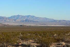
 Kingston Peak (center) seen from 22 miles to the northwest in Greenwater Valley | |
| Highest point | |
| Elevation | 7,326 ft (2,233 m) |
| Coordinates | 35°43′36″N 115°54′56″W / 35.7266685°N 115.9155473°W |
| Geography | |
| Location | San Bernardino, California |
| Parent range | Kingston Range |
| Topo map | USGS Kingston Peak |
Kingston Peak is the only named peak in the Kingston Range, a small desert mountain range in San Bernardino County, California, in the Mojave Desert. The highest point in the Kingston Range's 17-mile U-shaped continuous ridgeline, the peak has an elevation of 7,326 feet (2,233 metres) and a topographic prominence of ??? 628 ft (191 m).[1][2]
Kingston Peak and the Kingston Range lie within the Kingston Range Wilderness, administered by the Bureau of Land Management (BLM) and one of California's most botanically diverse desert regions. One of only three white fir stands in the California deserts is found on the slopes of two drainages just below the summit of Kingston Peak. https://www.blm.gov/visit/kingston-range-wilderness
Kingston Peak and Range also form part of the Basin and Range Province, along with neighboring mountains and ranges, such as the A Range to the B, and the C Range to the D.
Naming
editAbcd.[3]
See also
edit- Abcd
References
edit- ^ "Kingston Peak Feature Details". USGS Geographic Names Information System. Retrieved 2022-08-08.
- ^ "Nopah Peak, California". Peakbagger.com. Retrieved 2022-08-08.
- ^ Gudde, Erwin Gustav (1998). California Place Names. Revised and enlarged by William Bright, digitization sponsored by Internet Archive (4th ed., rev. and enl. ed.). Berkeley: University of California Press. ISBN 978-0-520-21316-6.
Category:Mountains of Inyo County, California Category:North American 2000 m summits

