|
This page is a sandbox of user:Polimerek. It serves as a testing spot and page development space for the user and is not an encyclopedia article.
|
Patra
Πάτρα | |
|---|---|
Settlement | |
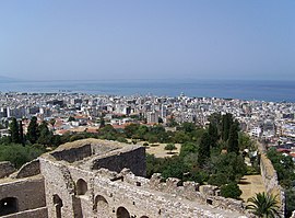
 View of Patras from the fortress | |
| Coordinates: 38°15′N 21°44′E / 38.250°N 21.733°E | |
| Country | Greece |
| Geographic region | Peloponnese |
| Administrative region | Western Greece |
| Regional unit | Achaea |
| Districts | 11 |
| Government | |
| • Mayor | Kostas Peletidis (KKE) |
| Area | |
| • Metro | 738.9 km2 (285.3 sq mi) |
| • Municipal unit | 125.4 km2 (48.4 sq mi) |
| Highest elevation | 10 m (30 ft) |
| Lowest elevation | 0 m (0 ft) |
| Population (2011)[1] | |
| • Metro | 260,308 |
| • Metro density | 350/km2 (910/sq mi) |
| • Municipal unit | 171,484 |
| • Municipal unit density | 1,400/km2 (3,500/sq mi) |
| Time zone | UTC+2 (EET) |
| • Summer (DST) | UTC+3 (EEST) |
| Postal code | 26x xx |
| Area code(s) | 261 |
| Vehicle registration | ΑΧ,AZ |
| Website | www |
Patras (Greek: Πάτρα, Greek pronunciation: [ˈpatra], Classical Greek and Katharevousa: Πάτραι (pl.), Greek pronunciation: [pátrai̯], Latin: Patrae (pl.)) is Greece's third-largest city and the regional capital of Western Greece, in the northern Peloponnese, 215 km (134 mi) west of Athens. The city is built at the foothills of Mount Panachaikon, overlooking the Gulf of Patras.
Patras has a population of 213,984 (in 2011).[1] The core settlement has a history spanning four millennia; in the Roman period it had become a cosmopolitan center of the eastern Mediterranean whilst, according to Christian tradition, it was also the place of Saint Andrew's martyrdom.According to the results of 2011 census, the metropolitan area has a population of 260,308 and extends over an area of 738.87 km2.
Dubbed as Greece's Gate to the West, Patras is a commercial hub, while its busy port is a nodal point for trade and communication with Italy and the rest of Western Europe. The city has two public universities and one Technological Institute, hosting a large student population and rendering Patras a major scientific centre with a field of excellence in technological education. The Rio-Antirio bridge connects Patras' easternmost suburb of Rio to the town of Antirrio, connecting the Peloponnese peninsula with mainland Greece.
Every year, in February, the city hosts one of Europe's largest carnivals: notable features of the Patras Carnival include its mammoth satirical floats and balls and parades, enjoyed by hundreds of thousands of visitors in a Mediterranean climate. Patras is also famous for supporting an indigenous cultural scene active mainly in the performing arts and modern urban literature. It was European Capital of Culture in 2006.[2]
Geography
editPatras is 215 km (134 mi) west of Athens by road, 94 km (58 mi) northeast of Pyrgos, 7 kilometres (4 miles) south of Rio, 134 km (83 miles) west of Corinth, 77 km (48 miles) northwest of Kalavryta, and 144 km (89 mi) northwest of Tripoli.
A central feature of the urban geography of Patras is its division into upper and lower sections. This is the result of an interplay between natural geography and human settlement patterns; the lower section of the city (Kato Poli), which includes the 19th-century urban core and the port, is adjacent to the sea and stretches between the estuaries of the rivers of Glafkos and Haradros. It is built on what was originally a bed of river soils and dried-up swamps. The older upper section (Ano Poli) covers the area of the pre-modern settlement, around the Fortress, on what is the last elevation of Mount Panachaikon (1,926 m (6,319 ft))[3] before the Gulf of Patras.
See also
editNotes
edit
References
edit- ^ a b "Απογραφή Πληθυσμού - Κατοικιών 2011. ΜΟΝΙΜΟΣ Πληθυσμός" (in Greek). Hellenic Statistical Authority.
- ^ https://www.theguardian.com/travel/2006/jan/29/greece.observerescapesection
- ^ "Region of Western Greece: Geography". Ditikiellda-region.com. Retrieved February 9, 2007.
Bibliography
edit- title.
External links
edit

