The Val d'Or train station is a station on the railway line from Paris-Saint-Lazare to Versailles-Rive-Droite, located in the commune of Saint-Cloud, in the Hauts-de-Seine department of the Île-de-France region.
Val d'Or | |
|---|---|
 The travelers' building in 2018. | |
| General information | |
| Location | France |
| Owned by | SNCF |
| Line(s) | Line OF Paris-Saint-Lazare at Versailles-Rive-Droite |
In 1903, the Compagnie des chemins de fer de l'Ouest launched a halt to serve the Fouilleuse racecourse (now the Saint-Cloud racecourse). The halt took on its current name and configuration in 1911 when it became a station. From 1918 to 1952, it served companies in Suresnes and Rueil-Malmaison, including a military arsenal. In the early 2000s, it was completely renovated, with a new footbridge and facilities that make it a model of accessibility for the disabled.
It is a Société nationale des chemins de fer français (SNCF) passenger station, served by Transilien line L trains. It is 12.8 km from Paris-Saint-Lazare station.
Railway location
editAt an altitude of 78 ma, Val d'Or station is located at kilometre point (PK) 12.769 on the Paris-Saint-Lazare to Versailles-Rive-Droite line, between the Suresnes-Mont-Valérien and Saint-Cloud stations.[1]
Toponymy
editVal d'Or was, at the time of the station's creation in 1903, the name of the path running from the Saint-Cloud racecourse to the boat station on the Seine, after crossing the tracks of the Paris-Saint-Lazare to Versailles line and the Moulineaux line.[2] In 2013, it was included in the name of the "Hippodrome/Fouilleuse/Val d'Or" district, where the station is located.[3]
The micro toponym Val d'Or is attested in various forms: Vaudor in 1606,[4] Vaulx d'or in July 1607,[5] Vaux d'or in November 1607[6] and Veau d'or in August 1811.[7] It recalls the location of a "rich and fertile valley" between Saint-Cloud and Suresnes.[8]
History
edit1903: Saint-Cloud racetrack stopover
edit
The line from Asnières to Versailles (Rive droite), officially opened on August 4, 1839, by the Société anonyme du chemin de Versailles (Rive droite), did not include a stop between the Saint-Cloud station and the Suresnes station opened a year later.[9]
The need for a new stop arose with the creation of the Saint-Cloud racecourse on the Fouilleuse plain. Shortly before its inauguration on March 15, 1901,[3] Le Sport universel illustré reported that several existing or planned means of spectator access were available, including creating a new station, 400 meters from the entrance via the Chemin du Val d'Or. This will be closer than the new station at Les Coteaux, on the Moulineaux line, or the boat dock at Les Coteaux de Saint-Cloud, access to which is blocked by the Paris-Saint-Lazare to Versailles-Rive-Droite line (see map opposite).[2]

As a result, and to facilitate access to the racecourse, the Société des Coteaux du Bois de Boulogne et de Longchamp requested the construction of a footbridge over the tracks at kilometre point (PK) 12.852. Authorization was obtained in September 1901, for a temporary footbridge two meters wide. The company agreed, at its own expense, to extend it and transform it into a metal footbridge, as soon as it was decided to build a rest area.[10]
On January 17, 1902, the decision to build a stopover was communicated to the directors of the Compagnie des chemins de fer de l'Ouest. Work began in May at a point roughly equidistant between the Suresnes and Saint-Cloud stations.[11] In 1903, the "Saint-Cloud racetrack"[12] station went into service. It has two platforms, with a special track serving the up platform, established between the stop and Saint-Cloud. Its construction led to the widening to thirteen meters of the opening of the bridge on rue du Calvaire, known as the "Pont des Trois Pierrots".[12] A four-meter-wide footbridge completed the project. When it opened, trains on the Paris to Versailles line served it only on race days at the Plaine de Fouilleuse racecourse.[2]
1911: Val d'Or station
editThe decree of December 29, 1909, authorized the commune of Saint-Cloud to borrow 40,000 Fr to pay a subsidy of 80,000 Fr, together with other resources, for work to transform the station into a rest area. The decree also authorized the Administration des chemins de fer de l'Etat[13] to levy local surcharges on passengers using the new station (5 centimes per one-way ticket and 10 centimes per return ticket) for a maximum period of ten years.[14]
In 1911, the State set up sidings at various stations on the line, notably at the Saint-Cloud racecourse stop known as "Val d'Or", for freight trains that were impeding passenger traffic. In the same year, the State carried out work to transform the former stopover into a passenger station, renaming it the Val d'Or station.[15] The passenger building was erected at the same time.[12] On October 7, 1911, the Saint-Cloud town council expressed the wish that the station be renamed "Saint-Cloud - Val-d'Or", but this request was not acted upon.[16]
- The station before 1914
-
 The passenger building.
 -
 A train stopped in front of the passenger building.
 -
 A general view of the station.


1918-1952: station and dock spur
edit
In 1917, the Atelier de Construction de Puteaux, an arsenal lacking available space on its original site, decided to relocate part of its production to Rueil, and to connect the new workshop "to the Val d'Or railroad line".[17]

At the end of the First World War, the station's facilities were modified when a special branch line was set up to serve "the docks and sand chambers to be built on the Fouilleuse plain [...] by the artillery department of the Puteaux arsenal".[16] The docks line is a single-track branch line 2,500 meters long, crossing the territory of the three communes of Saint-Cloud, Suresnes, and Rueil-Malmaison. It branches off from the Versailles line north of the Val d'Or station, and heads north-west on a steep gradient for the first 250 meters,[18] where a four-meter difference in level has to be overcome. At Val d'Or station, sidings are set up, connected to the special upward track.[16]
In 1918, along the Boulevard de Versailles, the branch line was connected to the Chemin de fer du Bois de Boulogne (CFBB), Porte Maillot - Val d'Or - Saint-Cloud, which in 1921 became tramway line 44 of the Société des transports en commun de la région parisienne (STCRP). This junction enabled two daily runs between Porte Maillot and Rueil-Malmaison for staff. The section was electrified from the boulevard de Versailles to the Rueil factory.[16]
In the early 1920s, the modest facilities at Rueil became the Rueil factory - or arsenal - part of the Atelier de Construction de Puteaux (APX), located along Boulevard National in Puteaux. In 1926-1927, the mayors of Rueil-Malmaison and Suresnes entered into discussions with the STCRP and the military authorities to introduce passenger traffic on the branch line. However, the project was abandoned: line 44 was withdrawn on December 28, 1936, during the great wave of tramway withdrawals in France, and replaced by a bus line bearing the same name. As early as 1927, the very poor condition of the spruce sleepers prompted the arsenal to consider transferring goods to the road.[16]
Between March 20 and April 17, 1932, a detachment consisting of an officer, a warrant officer, three non-commissioned officers, and sixty corporals and sappers modified 650 meters of the "military track connecting the Puteaux arsenal to the Val d'Or station".[19]
On October 19, 1945, at 12:45 p.m., a serious accident occurred on the junction at the Croix du Roy crossroads, when a train carrying two thirty-tonne tanks to the arsenal collided with a bus from line 44: several people were killed and around fifteen injured. In 1953, a local street was named after Dr. Bombiger, in recognition of his dedication to helping the injured in this accident.[16]
The operation of the branch line was the subject of an agreement with the French State Railways Administration, then the SNCF, which supplied the traction equipment; the last agreement was signed in July 1950. When the Rueil plant's activities were reoriented, with a sharp reduction in the transport of heavy equipment, the branch line was finally abandoned in 1959. That year, the SNCF received Fr. 445,000 for traction and Fr. 70,000 for weeding the branch line.[16]
At the end of the 1960s, the army gradually handed over the Rueil factory site to Régie Renault. Today, part of the branch line site is occupied by the parking lot of the Parc du Val d'Or residence (the tall "S"-shaped building, in white in the photo opposite). Some traces of the railroad line are still visible on aerial views.[12]
Service evolution from 1928 to 2004
editThe station, served by electric commuter trains since the installation of a third power rail in 1928,[20] was adapted for the installation of the new catenary power supply commissioned in 1976.[21] It became a station on the tangential line, with the installation of a permanent counter-current facility (IPCS) between the station and the Suresnes-Mont-Valérien station in 1995.[22] The line and the station were integrated into the new Transilien network in 1999[23] and then, in 2004, into the U line, the tangential line's new name (La Défense - La Verrière).[24]
2008-2013: renovation and accessibility
edit
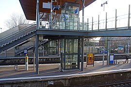
In the early 2000s, the old footbridge, which overlooks the station and provides access to the platforms as well as a link between the upper and lower towns of Saint-Cloud, was tired after more than a century of use. Consideration was given to replacing it, taking into account the need for disabled access and the constraints imposed by its cramped site, its various functions and its aesthetic appeal, since it is located in the protected natural area of Mont Valérien. This project is being fine-tuned by its promoters, the SNCF, as part of its "Mobigare" reference system, and the Île-de-France region, with its "deployment of accessibility projects" program, in consultation with the town of Saint-Cloud and associations.[25][26][27]
The focal point of this major project is the construction of a new public footbridge overhanging the railway line, with the commune's pathways between the top and bottom of the hillside. Its links with the railway site, in particular platforms A and B, comprise four elevators, two escalators, and four fixed staircases. The platforms and the old passenger building are also included in the project, with major renovations.[26]
To make the site as accessible as possible, the work will involve replacing the furniture, removing any obstacles to movement, modifying the flooring, installing signage adapted to different types of disability, and upgrading the lighting. For ticket control, a wider walkway has been installed, and a new "Transilien fast machine" has been installed. All in all, the improvements cover all types of disability, whether physical or sensory.[26]
In March 2011, before the project was completed, the Val d'Or station site was one of thirteen winners of the "competition to collect best practices and good practices in terms of accessibility".[26]
- Worksite in March 2011
-
 Passenger building.
 -
 View from the footbridge.
 -
 New footbridge.


The tracks are also being renovated. In January 2013, the SNCF set up a lightning strike involving some 200 workers. In just forty-eight hours, they replaced three switches and 850 m of track, including new ballast.[28]
2015-2016, service changes
editEnd of Line U service
edit
In 2013, users of line L, fed up with recurrent delays and trains that passed without stopping, set up the "Plus de trains pour la Défense" association. After winning over other users, the association organized itself with at least one representative for each station on the line. They take an interest in the entire line and its timetables. This enables them to open up a real dialogue with the SNCF. Two line committees have been set up, and have succeeded in moving the issue forward by making emergency proposals such as canceling a train, whether direct or not so that subsequent trains can stop at all stations without worrying about delays. The SNCF's executives are being shaken up; one of them admits: "For a long time, we were willing to sacrifice 1,000 passengers so that the next 50,000 would be right on time. We've changed".[29]
As of the implementation of the 2016 annual service on December 13, 2015, the station is no longer served by Transilien line U trains, which had all stopped there since the line's creation on May 28, 1995. This discontinuation of service to the station, as well as the change in the overall service offering, was justified because "the quality of service on line L Sud has deteriorated [...] does not meet emerging and future needs, mainly towards La Défense [...] has several intrinsic weaknesses".[30]
Continued service on line L
editOn the same December 13, 2015, a new timetable altered the frequency of train service on Transilien line L, when the 2016 annual service came into effect. The station's "500 users" "see themselves as sacrificed" when choices were made to improve traffic flow on lines L and U. Nevertheless, the most penalized in terms of travel time are those who are not heading for Paris but for other suburban towns, such as Suresnes for Dassault Aviation employees.[31]
On January 14, 2016, the first impressions were that there were fewer people on the trains, allowing them to board instead of waiting for the next one, and that there were also fewer train cancellations. Passengers are now waiting for the promises of major investment in rolling stock renewal and infrastructure improvements to be fulfilled, to achieve a truly efficient transport service.[31]
Station ridership
editDaily upward traffic reached 1,153 passengers in 1938, 2,950 in 1973, and finally dropped to 2,200 passengers per day in 2003, following the introduction of tramway line 2 in 1997.[32]
Passenger services
editReception
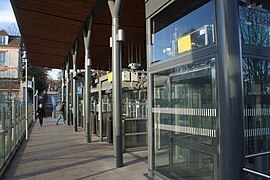
editA Transilien station, it has a passenger building open every day, equipped with automatic ticket machines for purchasing Transilien and mainline tickets.[33] There are also vending machines for drinks,[34] snacks, and newspapers. A footbridge, equipped with elevators and escalators, is accessible from rue du Pierrier and avenue Alfred-Belmontet and provides access across the tracks and to the platforms.[26]
Near the footbridge, on the rue du Pierrier side, a Lions club - a service club - financed the installation of a "book box", which was inaugurated on May 30, 2018. These boxes, deployed in several French towns or stations, are designed to enable the circulation of books, similar to bookcrossing.[35][36]
- The footbridge in December 2015
-
 Access to the footbridge.
 -
 Footbridge and elevators.
 -
 Platforms and elevators.


Service
editThe station is served by Transilien Paris Saint-Lazare "regional" L line trains to and from Saint-Nom-la-Bretêche (except in the early morning and late evening, when service is also provided by trains to and from Versailles-Rive-Droite), with a train every 10 minutes during rush hour and every 15 minutes during off-peak hours and in the evening.[33]
Travel time from Paris-Saint-Lazare is 18 min, except for the first train of the day and the late evening trains from 9:41 p.m. when it is 21 min.[37] For information, according to Google Maps estimates, the same journey by car takes 25 to 30 min, depending on the route taken.[38]
- Service in February 2019
-
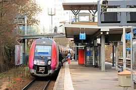 Z 50000 no 122L train to Paris-Saint-Lazare.
 -
 Train Z 50000 no 122L towards Saint-Cloud.
_par_Cramos.JPG)
_par_Cramos.JPG)
Intermodality
editPassengers have access to a bicycle park and a paid parking lot with a capacity of 100 to 200 spaces.[33] According to the Transilien L line diagram,[39] a connection via the public highway (via avenue de Longchamp[40]) is possible with the Les Coteaux station on the T2 tramway line.
The station is served by lines 144, 160, 244, 360, and 471 of the RATP bus network, by line 40 of the Argenteuil - Boucles de Seine bus network, and, at night, by line N53 of the Noctilien network.
See also
editReferences
edit- ^ Douté (2011, p. 208)
- ^ a b c Fox, H. (1901). "Le nouvel hippodrome de Saint-Cloud". Le Sport universel illustré. 1 (242): 152–153.
- ^ a b Berdoati, Éric (2013). "Au cœur du quartier Hippodrome/Fouilleuse/Val d'Or autrefois". Saint-Cloud quartiers: Supplément quartiers de Saint-Cloud magazine (4).
- ^ Baillère (1900, p. 46)
- ^ Baillère (1900, pp. 53–55)
- ^ Baillère (1900, p. 56)
- ^ Baillère (1900, p. 59)
- ^ Suresnes, ses lieux dits et ses rues vous parlent (in French). Société historique de Suresnes. 1968. p. 47.
- ^ Palau & Palau (2003, p. 57)
- ^ Bouchez (2007, p. 76)
- ^ "Informations: Une nouvelle gare à Saint-Cloud". Le Journal des transports: Revue internationale des chemins de fer et de la navigation: 218. 1902.
- ^ a b c d Bouchez (2007, p. 77)
- ^ Caron (2005, p. 304)
- ^ "Homologations de tarifs: Création de surtaxes temporaires". Le Journal des transports: Revue internationale des chemins de fer et de la navigation (in French) (28): 364. 1911.
- ^ "Les nouveaux travaux des chemins de fer de l'État pour l'amélioration de la gare Saint-Lazare et du service de banlieue: suite". Le Journal des transports: Revue internationale des chemins de fer et de la navigation (in French) (9): 111. 1911.
- ^ a b c d e f g Bouchez (2007, p. 78)
- ^ Berthonnet, Arnaud; Gousset, Sylvie (2005). Rueil-Malmaison, terre d'entreprises : Une histoire d'hommes et d'initiatives économiques (1800–2005) (in French). InSiglo. ISBN 2-9525-3100-5.
- ^ Jeuge-Maynart, Isabelle. "Rampe: Définitions". www.larousse.fr (in French).
- ^ L. D. (1932). "L'œuvre économique du génie en 1931". Revue du génie militaire. 70: 258.
- ^ Bouchez (2007, p. 26)
- ^ Collardey (1999, p. 335)
- ^ Collardey (1999, p. 246)
- ^ Lalu, Vincent. "Transilien, RER et trams d'aujourd'hui". Les Éditions la Vie du rail (in French) (9): 61. ISSN 2264-5411.
- ^ Bouzou, Nicolas; Timoshkin, Hélène (2016). "SNCF Transilien: Un réseau au service de la mobilité urbaine" (PDF). Asterès (in French): 48.
- ^ Ministère de l'Égalité des territoires et du Logement; Ministère de l'Écologie, du Développement durable et de l'Énergie (2012). "5e assises nationales de l'accessibilité: Les actes". Ministère de l'Écologie, du Développement durable et de l'Énergie. Archived from the original on 2007-06-15.
- ^ a b c d e Volant, Stéphane (2012). "La gare du Val d'Or, modèle de bonnes pratiques en matière d'accessibilité". Société nationale des chemins de fer français. Archived from the original on 2007-06-15.
- ^ SNCF-Gares (2012). "Gare et accessibilité, Saint-Cloud (92): une passerelle entre ville et train". Recueil de belles pratiques et de bons usages en matière d'accessibilité de la cité (in French). Ministères de l'Égalité et de l'Écologie. p. 54.
- ^ "Chantier éclair pour changer 850 m de voie". Le Parisien libéré. 2013.
- ^ "Nouveaux horaires sur la Ligne L: les voyageurs ont eu leur mot à dire". www.leparisien.fr.
- ^ Probst, Laurent (2014). "Comité sur l'évolution de l'offre: lignes L sud et U". Syndicat des transports d'Île-de-France (in French). Archived from the original on 2007-06-15.
- ^ a b O. B. (2016). "Nouvelle grille horaire de la ligne L: " Ça change vraiment la vie "". Le Parisien libéré (in French).
- ^ Gares et connexions (25 February 2019). "Fréquentation en gares: Tableau". data.sncf.com (Le Val d'Or). La Plaine Saint-Denis: SNCF. Retrieved 2 March 2019.
- ^ a b c Krakovitch, Alain. "Gare Le Val d'Or". www.transilien.com.
- ^ Krakovitch, Alain. "Plan de la ligne L". SNCF Mobilités. Archived from the original on 2007-06-15.
- ^ AP Bookies (2018). "Une boîte à livres au Val d'Or". www.les-bookies.fr.
- ^ "Tous écoresponsables, demandez le programme !: Mercredi 30 mai à 19 h inauguration des boîtes à livres". Saint-Cloud magazine. 2018. Archived from the original on 2007-06-15.
- ^ Krakovitch, Alain (2018). "Ligne L - Horaires Transilien du 9 décembre 2018 au 6 juillet 2019 du lundi au vendredi". www.transilien.com (in French). Archived from the original on 2007-06-15.
- ^ "Carte de trois itinéraires entre la gare Saint-Lazare et la gare du Val d'Or". Google Maps (in French). 2019.
- ^ Krakovitch, Alain. "Plan de la ligne L". www.transilien.com. Archived from the original on 2007-06-15.
- ^ "Tracé de l'avenue de Longchamp" (in French). 2019.
Bibliography
edit- Baillère, Henri (1900). Autour d'une source: la fontaine des Vaux-d'Or, la sente de Saint-Cloud à Suresnes, la tourelle de la porte de Saint-Cloud (in French). J.-B. Baillière et fils.
- Bouchez, Pierre (2007). De Paris Saint-Lazare à Versailles et Saint-Nom la Bretèche : 1839-2007 (in French). Les Éditions La Vie du rail. ISBN 978-2-9150-3467-7.
- Caron, François (2005). Les Grandes Compagnies de chemin de fer en France 1823-1937. Publications d'histoire économique et sociale internationale; archives économiques du Crédit lyonnais (in French). Droz. ISBN 2-600-00942-6.
- Collardey, Bernard (1999). Les Trains de banlieue, vol. 2 : De 1938 à 1999 (in French). La Vie du rail et des transports. ISBN 2-9028-0876-3.
- Douté, Reinhard (2011). Profils de lignes du réseau ferré français (in French). Les Éditions La Vie du rail. ISBN 978-2-9187-5844-0.
- Palau, François; Palau, Maguy (2003). Le Rail en France : les 80 premières lignes 1828-1851 (in French). F. et M. Palau. ISBN 2-9509-4210-5.