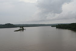
The Valapattanam River is a 110 km long river which flows through the Kannur district in North Kerala. It is the longest river in the Kannur district.[1]
| Valapattanam വളപട്ടണം നദി | |
|---|---|
 A view of Valapattanam river from Parassinikkadavu Bridge. | |
 | |
| Location | |
| Country | India |
| State | Kerala |
| District | Kannur |
| Physical characteristics | |
| Mouth | |
• location | Arabian Sea (Azhikkal Port) |
• elevation | 0 m (0 ft) |
| Length | 110 km (68 mi) |
| Basin features | |
| Progression | West flowing river |
| Landmarks | Muthappan temple |
Course
editThe Valapattanam River originates from the Brahmagiri hills of Western Ghats in Karnataka. Initially the river flows towards the eastern direction through some villages in the hilly Malenadu region of Karnataka, like Matyani, Birunani, Poradu, Badagarakeri and Kikkod.[1] Later it takes a sharp bend toward the west and flows through a narrow deep valley descending towards the hilly regions of Kannur district.[1] It then flows through the hilly region of Kannur, passing through Manikkadavu, Vattiyamthode, Vayathur, Nuchiyad, Chamathachal, Uchatthu kayam (where the Payyavoor river joins), Madambam[2] The river then enters the Malabar plains where it flows through the towns of Sreekandapuram, Chengalayi, Mungam, Koyyam (where the Bavali river joins), Kandakkai, Mullakkodi Nanichery, Parassinikadavu, Kolachery, Kambil, Narath, Velapuram, Pappinissery, Azhikode and empties into the Arabian Sea at Azhikkal where the Kuppam river joins the Valapattanam.[3][1]
Tributaries
edit- Payyavoor river
- Aralam river
- Veni river
- Bavali river
- Pulloopi river
- Mundayapuzha river
References
edit- ^ a b c d Nair, Adoor K. K. Ramachandran (1989). Kerala State Gazetteer. State Editor, Kerala Gazetteers.
- ^ India, Geological Survey of (1999). Records of the Geological Survey of India. The Survey.
- ^ Nazeer, Mohamed (11 August 2015). "Concern over water quality in Valapattanam river". The Hindu. ISSN 0971-751X. Retrieved 23 May 2021.
11°56′N 75°18′E / 11.933°N 75.300°E