Wayne Township is one of twelve townships in Huntington County, Indiana, United States. As of the 2020 census, its population was 470.[1]
Wayne Township | |
|---|---|
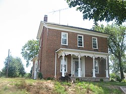
 The Chenoweth-Coulter Farmhouse, a historic site in the township | |
 Location in Huntington County | |
| Coordinates: 40°41′49″N 85°36′10″W / 40.69694°N 85.60278°W | |
| Country | United States |
| State | Indiana |
| County | Huntington |
| Government | |
| • Type | Indiana township |
| Area | |
• Total | 24.41 sq mi (63.2 km2) |
| • Land | 24.36 sq mi (63.1 km2) |
| • Water | 0.05 sq mi (0.1 km2) 0.20% |
| Elevation | 853 ft (260 m) |
| Population (2020) | |
• Total | 470 |
| • Density | 22.2/sq mi (8.6/km2) |
| GNIS feature ID | 0454032 |
History
editWayne Township was organized in 1844.[2] Some of the early settlers being natives of Wayne County, Indiana caused the name to be selected.[3]
The Chenoweth-Coulter Farm was listed on the National Register of Historic Places in 2009.[4]
Geography
editAccording to the 2010 census, the township has a total area of 24.41 square miles (63.2 km2), of which 24.36 square miles (63.1 km2) (or 99.80%) is land and 0.05 square miles (0.13 km2) (or 0.20%) is water.[5] The stream of Prairie Creek runs through this township.
Cities and towns
edit- Mount Etna (southwest edge of town, northeast edge of Twp.)
Unincorporated towns
editAdjacent townships
edit- Polk Township (north)
- Lancaster Township (northeast)
- Jefferson Township (east)
- Van Buren Township, Grant County (southeast)
- Washington Township, Grant County (south)
- Liberty Township, Wabash County (west)
- Lagro Township, Wabash County (northwest)
Cemeteries
editThe township contains one cemetery, Gardens of Memory.
Major highways
editDemographics
edit| Census | Pop. | Note | %± |
|---|---|---|---|
| 1890 | 1,047 | — | |
| 1900 | 900 | −14.0% | |
| 1910 | 955 | 6.1% | |
| 1920 | 755 | −20.9% | |
| 1930 | 658 | −12.8% | |
| 1940 | 617 | −6.2% | |
| 1950 | 590 | −4.4% | |
| 1960 | 612 | 3.7% | |
| 1970 | 659 | 7.7% | |
| 1980 | 621 | −5.8% | |
| 1990 | 549 | −11.6% | |
| 2000 | 559 | 1.8% | |
| 2010 | 540 | −3.4% | |
| 2020 | 470 | −13.0% | |
| US Decennial Census[6] | |||
References
edit- ^ "Township Census Counts: STATS Indiana".
- ^ History of Huntington County, Indiana: From the Earliest Time to the Present. Brant & Fuller. 1887. pp. 874.
- ^ Bash, Frank Sumner (1914). History of Huntington County, Indiana: A Narrative Account of Its Historical Progress, Its People, and Its Principal Interests. The Lewis Publishing Company. pp. 129.
- ^ "National Register Information System". National Register of Historic Places. National Park Service. July 9, 2010.
- ^ "Population, Housing Units, Area, and Density: 2010 - County -- County Subdivision and Place -- 2010 Census Summary File 1". United States Census. Archived from the original on February 12, 2020. Retrieved May 10, 2013.
- ^ "Township Census Counts: STATS Indiana".