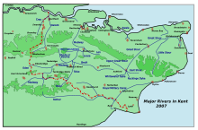
Whitehall Dyke is a tributary of the Great Stour river in Kent, England.
| Whitehall Dyke | |
|---|---|
 | |
| Physical characteristics | |
| Source | |
| • location | Harbledown |
| Mouth | |
• location | Great Stour, Thanington Without near Canterbury |
| Length | 5.6 km (3.5 mi) |

The stream runs from its source near Harbledown, 5.6 kilometres, to the Great Stour at Thanington Without near Canterbury.[1]
The overall condition of the water body was rated as moderate in 2009, but declined to poor overall in 2014.[2]
References
edit- ^ The Environment Agency
- ^ "Environment Agency - Catchment Data Explorer". environment.data.gov.uk. Retrieved 24 February 2016.
51°16′39″N 1°04′10″E / 51.2774°N 1.0695°E