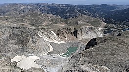
Wind River Glacier is in the Wind River Range, Shoshone National Forest, in the U.S. state of Wyoming. The glacier is situated on the northeast slope of Wind River Peak (13,192 feet (4,021 m)), the tallest peak in the southern Wind River Range.[2]
| Wind River Glacier | |
|---|---|
 Wind River Glacier viewed from the summit of Wind River Peak | |
| Type | Mountain glacier |
| Location | Fremont County, Wyoming, USA |
| Coordinates | 42°42′31″N 109°07′41″W / 42.70861°N 109.12806°W[1] |
| Length | .45 mi (0.72 km) |
| Terminus | Proglacial lake |
| Status | Unknown |
See also
editReferences
edit- ^ "Wind River Peak". Geographic Names Information System. United States Geological Survey, United States Department of the Interior. Retrieved August 26, 2012.
- ^ Temple Peak, WY (Map). TopoQwest (United States Geological Survey Maps). Retrieved August 26, 2012.
External links
edit
