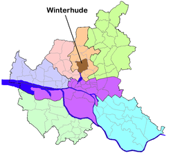
Winterhude () is a quarter in the ward Hamburg-Nord of Hamburg, Germany. As of 2020 the population was 56,382.
Winterhude | |
|---|---|
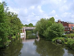
 The channel Goldbekkanal with Hamburg U-Bahn bridge. | |
| Coordinates: 53°36′0″N 10°0′0″E / 53.60000°N 10.00000°E | |
| Country | Germany |
| State | Hamburg |
| City | Hamburg |
| Borough | Hamburg-Nord |
| Area | |
• Total | 7.6 km2 (2.9 sq mi) |
| Population (2023-12-31)[1] | |
• Total | 60,435 |
| • Density | 8,000/km2 (21,000/sq mi) |
| Time zone | UTC+01:00 (CET) |
| • Summer (DST) | UTC+02:00 (CEST) |
| Dialling codes | 040 |
| Vehicle registration | HH |
History
editWinterhude was first mentioned in the 13th century,[2] but archeological findings of tools, weapons and grave-mounds were dated to 1700 BC and 700 BC.[3]
During World War II the port of Hamburg and therefore Winterhude were targets of the air raids of the so-called Operation Gomorrah.
This section needs expansion. You can help by adding to it. (March 2009) |
Geography
editIn 2006 according to the statistical office of Hamburg and Schleswig-Holstein, the Winterhude quarter has a total area of 7.6 km2. To the north is the Alsterdorf quarter and the Barmbek-Nord quarter is in the east. In the west are the Eppendorf and the Harvestehude quarters and in the south are the Uhlenhorst and Barmbek-Süd quarters.
The City Park of Hamburg (Hamburger Stadtpark) is located within Winterhude.
Demographics
editIn 2007, the population of the Winterhude quarter was 48,799. The population density was 6,439 inhabitants per square kilometre (16,677/sq mi). 10.6% were children under the age of 18, and 15% were 65 years of age or older. 11,8% were immigrants. 1,684 people were registered as unemployed.[4] In 1999, there were 31,732 households, and 60.4% of all households were made up of individuals. The average household size was 1.61.[5]
Population by year
| 1709 | 1810 | 1811 | 1834 | 1838 |
| 100 | 238 | 242 | 325 | 380 [6] |
| 1939 | 1950 | 1961 | 1970 | 1980 |
| 65,937 | 90,623 | 79,235 | 61,899 | 50,787 [7] |
| 1987 | 1988 | 1989 | 1990 | 1991 | 1992 | 1993 | 1994 | 1995 | 1996 | 1997 | 1998 | 1999 |
| 47,225 | 46,988 | 47,236 | 47,767 | 48,404 | 49,460 | 49,449 | 49,819 | 49,040 | 49,192 | 48,536 | 48,536 | 48,756[8] |
| 2000 | 2001 | 2002 | 2003 | 2004 | 2005 | 2006 | 2007 |
| 48,653 | 48,469 | 48,421 | 48,610 | 48,532 | 48,602 | 49,018 | 48,799[8] |
In 2007 there were 4,622 criminal offences (95/1000 people).[8]
Education
editIn 2006 there were 6 elementary schools and 3 secondary schools in the Winterhude quarter with 3,959 pupils.[9]
Infrastructure
editEstablished in 1956, the Consulate-General of the Republic of Indonesia is located in the quarter.[10] The Consulate-General of the Islamic Republic of Iran was established in 1858 and is also located in the street Bebelallee.[11]
Health systems
editThe hospital Israelitisches Krankenhaus has 180 beds.[12]
There were 32 day-care centers for children, 156 physicians in private practice and 16 pharmacies.[8]
Transportation
editWinterhude is serviced by the rapid transit system of the underground railway with several stations: Sierichstraße, Borgweg und Saarlandstraße (yellow line U3), Hudtwalkerstraße and Lattenkamp (blue line U1) . According to the Department of Motor Vehicles (Kraftfahrt-Bundesamt), in the quarter Winterhude were 15,992 private cars registered (328 cars/1000 people).[8]
Notes
edit- ^ "Bevölkerung in Hamburg am 31.12.2023 nach Stadtteilen". Statistisches Amt für Hamburg und Schleswig-Holstein. May 2024.
- ^ Sparmann 1968, p. 401
- ^ Schindler 1960, S. 284 et sqq.
- ^ Residents registration office, source: statistical office Nord of Hamburg and Schleswig-Holstein (2007)
- ^ Source: statistical office Nord of Hamburg and Schleswig-Holstein (1999)
- ^ Neddermeyer (1847), Zur Statistik und Topographie der Freyen und Hansestadt Hamburg (in German), Hamburg, pp. 88 et sqq. and 128
- ^ BAUBEHÖRDE HAMBURG 1981, S.11 and STATISTISCHES LANDESAMT. Statist. Taschenbücher: Einwohnerentwicklung 1973-1995
- ^ a b c d e Source: statistical office Nord of Hamburg and Schleswig-Holstein (2007)
- ^ Source: statistical office Nord of Hamburg and Schleswig-Holstein (2006)
- ^ List of the Consular corps, the trade missions, cultural institutes and international institutes in the Free and Hanseatic city of Hamburg (in German), pp. 13 and 38
- ^ List of the Consular corps, the trade missions, cultural institutes and international institutes in the Free and Hanseatic city of Hamburg (in German), pp. 14 and 38
- ^ Hospitals in Hamburg (PDF) (in German), Behörde für Soziales, Familie, Gesundheit und Verbraucherschutz Ministry of Social Affairs, Family Affairs, Health and Consumer Protection, 2008-01-01, retrieved 2008-02-28
References
edit- Statistical office Hamburg and Schleswig-Holstein Statistisches Amt für Hamburg und Schleswig-Holstein, official website (in German)
- List of the Consular corps, the trade missions, cultural institutes and international institutes in the Free and Hanseatic city of Hamburg: Liste des Konsularkorps sowie der Handelsvertretungen, der kulturellen Institute und der internationalen Institutionen in der Freien und Hansestadt Hamburg (PDF) (in German), Senate of the Free and Hanseatic city of Hamburg, Chancellery of the Senate, 2008
- Sparmann, Friedrich (1968), Links und rechts der Oberalster; eine kleine Heimatkunde (in German), Hamburg: Verlag der Gesellschaft der Freunde des Vaterländischen Schul- und Erziehungswesens, OCLC 13102927
- Schindler, Reinhard (1960), Die Bodenaltertümer der Freien und Hansestadt Hamburg Veröffentlichungen des Museums für Hamburgische Geschichte (in German), vol. Bd. 1, Hamburg: H. Christians, OCLC 24449473
External links
edit


