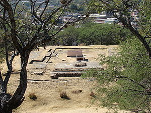
Zaachila (the Zapotec name; Nahuatl: Teotzapotlan; Mixtec: Ñuhu Tocuisi) was a powerful Mesoamerican city in what is now Oaxaca, Mexico, 6 km (3.7 mi) from the city of Oaxaca. The city is named after Zaachila Yoo, the Zapotec ruler, in the late 14th and early 15th century. Zaachila was home of Donaji- the last Zapotec princess.[1] Zaachila is now a historical location. In the middle is a sizable unexplored pyramid mound where two tombs were found in 1962.[2] These tombs are thought to belong to important Mixtec persons.[3]


Zaachila became the final Zapotec capital after Monte Alban fell. The Mixtecs took control of the capital prior to the arrival of the Spaniards.[4] The history of the pre-Hispanic city is unclear. One theory is that the site flourished 1100 and 1521 CE. Another theory is that the city was founded in 1399 and could be compared to Tenochtitlan, as it was a city in the middle of a lake. The full extent of the ancient city is not known either, principally because excavation is impeded by the fact that most mounds have inhabited structures on them.[5]
In 1971 new excavations found two more tombs registered with the numbers 3 and 4. Even though the offerings were simpler than the ones found by Gallegos, tomb 4 end up being of special interest because of the paint remains found on its lintel. Tree roots and rain infiltration have damaged the designs, according to Acosta (1972) they represent skulls and cross bones over a red colored background. Since 1990 the project "La pintura mural prehispánica en México" of the Institute of Aesthetic Research of the National Autonomous University of Mexico, it is dedicated to record and study of the pre-Columbian murals, like those from Zaachila.
Due population growth and neglect of the authorities a housing project was authorized which has add up to the damage and pillaging of this valuable archaeological site.
Nowadays, in this community barter is a common practice, every Thursday many merchants came to this place to exchange and sell their products.
The big festival of the Zaachila hill | Laanii Roo Xten Daan Zaadxil
editThe last Monday of July, the Zaachila community meets in the archaeological site, better known as "el cerrito," to honor the Corn Goddess (Pitao Ko Shuub), in traditional Laanii Roo Xten Daan Zaadxil.
The Goddess Pitao Ko Shuub is chosen among several young women who previously enrolled in a contest, the main demanded features are the long black hair, they must have brown skin and share a theme of the history of Zaachila. The chosen one will be host of all the activities of the festival.
Has the young women, the ten neighborhoods that conform the town organize months before the festival to represent the most iconic dances of various regions of Oaxaca, like: "La Flor de la Piña de Tuxtepec (the pineapple flower of Tuxtepec)," "El Jarabe de Ejutla," "Las Chilenas de la Costa," "El Jarabe Mixe," "Los Bailes del Itsmo de Tehuantepec," and has a central valley special input we found the "Dance of the Feather" and "Los Zancudos," this last one is performed by young men on stilts almost five feet tall.
In this festivity the ejidal authorities get involved, and they are in charge of giving to the participants tepache (a fruit fermented beverage), mezcal, atole and tamales.
This festival is one of the most colorful and joyful of the region because in this festival cultural events, calendas, parades, culinary samples and other events are celebrated too.
Climate
edit| Climate data for Zaachila | |||||||||||||
|---|---|---|---|---|---|---|---|---|---|---|---|---|---|
| Month | Jan | Feb | Mar | Apr | May | Jun | Jul | Aug | Sep | Oct | Nov | Dec | Year |
| Mean daily maximum °C (°F) | 28.1 (82.6) |
29.7 (85.5) |
31.3 (88.3) |
32.0 (89.6) |
32.3 (90.1) |
29.8 (85.6) |
29.0 (84.2) |
29.1 (84.4) |
28.7 (83.7) |
27.7 (81.9) |
27.5 (81.5) |
27.3 (81.1) |
29.4 (84.9) |
| Mean daily minimum °C (°F) | 7.1 (44.8) |
9.6 (49.3) |
10.7 (51.3) |
12.7 (54.9) |
13.7 (56.7) |
14.5 (58.1) |
14.4 (57.9) |
14 (57) |
14.3 (57.7) |
13.1 (55.6) |
10 (50) |
7.6 (45.7) |
11.8 (53.2) |
| Average precipitation cm (inches) | 0 (0) |
0.51 (0.2) |
1.8 (0.7) |
4.3 (1.7) |
9.4 (3.7) |
14 (5.4) |
11 (4.3) |
10 (4) |
13 (5) |
4.1 (1.6) |
1.0 (0.4) |
0.25 (0.1) |
69 (27) |
| Source: Weatherbase [6] | |||||||||||||
See also
editReferences
edit- ^ Wood, Stephanie; Megged, Amos (8 November 2012). Mesoamerican Memory: Enduring Systems of Remembrance. University of Oklahoma Press. ISBN 9780806188096. Retrieved 14 March 2018 – via Google Books.
- ^ "Zaachila: 14th century Oaxacan city has many unexplored gems1". Oaxaca Travel Guide. Retrieved 2007-08-10.
- ^ Quintanar Hinojosa, Beatriz (August 2007). "Joyas ocultas de los valles centrales". Guía México Desconocido: Oaxaca. 137: 88.
- ^ "Zaachila Archeological Ruins". Retrieved 2010-11-07.
- ^ "Oaxacaoaxaca.com:Zaachila". Retrieved 2008-02-26.
- ^ "Weatherbase: Historical Weather for Zaachila, Oaxaca". Weatherbase. 2011. Retrieved on November 24, 2011.