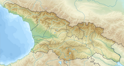
Zemo Okrokana (Georgian: ზემო ოქროყანა, literally — "Upper Golden Field") is a village in the historical region of Khevi, north-eastern Georgia. It is located on the right bank of the Tergi tributary river – Mnaisi. Administratively, it is part of the Kazbegi Municipality in Mtskheta-Mtianeti. Its distance to the municipality center Stepantsminda is 24 km.
Zemo Okrokana
ზემო ოქროყანა | |
|---|---|
 Village Zemo Okrokana in August, 2017 | |
| Coordinates: 42°35′11″N 44°27′57″E / 42.58639°N 44.46583°E | |
| Country | |
| Mkhare | Mtskheta-Mtianeti |
| Municipality | Kazbegi |
| Community | Kobi |
| Elevation | 2,080 m (6,820 ft) |
| Population (2014)[1] | |
• Total | 0 |
| Time zone | UTC+4 (Georgian Time) |
 | |
Okrokana is a possible starting point for the popular hike into Truso Valley, along the Terek River.[2]
Sources
edit- Georgian Soviet Encyclopedia, V. 4, p. 510, Tbilisi, 1979 year.
References
edit- ^ "Population Census 2014". www.geostat.ge. National Statistics Office of Georgia. November 2014. Retrieved 28 June 2021.
- ^ "Walk in Truso Valley". www.caucasus-trekking.com. Retrieved 2023-09-20.

