This is a list of earthquakes in 2024. Only earthquakes of magnitude 6 or above are included, unless they result in significant damage and/or casualties. All dates are listed according to UTC time. The maximum intensities are based on the Modified Mercalli intensity scale. Earthquake magnitudes are based on data from the USGS.
.svg) Approximate epicenters of the earthquakes in 2024
| |||
| Strongest magnitude | 7.5 Mw | ||
|---|---|---|---|
| Deadliest | 7.5 Mw 474 deaths | ||
| Total fatalities | 517 | ||
| Number by magnitude | |||
| 9.0+ | 0 | ||
| 8.0–8.9 | 0 | ||
| 7.0–7.9 | 8 | ||
| 6.0–6.9 | 82 | ||
| 5.0–5.9 | 1,264 | ||
| 4.0–4.9 | 11,200 | ||
← 2023 | |||
Compared to other years
edit| Magnitude | 2014 | 2015 | 2016 | 2017 | 2018 | 2019 | 2020 | 2021 | 2022 | 2023 | 2024 |
|---|---|---|---|---|---|---|---|---|---|---|---|
| 8.0–9.9 | 1 | 1 | 0 | 1 | 1 | 1 | 0 | 3 | 0 | 0 | 0 |
| 7.0–7.9 | 11 | 18 | 16 | 6 | 16 | 9 | 9 | 16 | 11 | 19 | 8 |
| 6.0–6.9 | 143 | 127 | 131 | 104 | 118 | 135 | 111 | 141 | 117 | 128 | 82 |
| 5.0–5.9 | 1,580 | 1,413 | 1,550 | 1,447 | 1,671 | 1,484 | 1,315 | 2,046 | 1,603 | 1,637 | 1,264 |
| 4.0–4.9 | 15,817 | 13,777 | 13,700 | 10,544 | 12,782 | 11,897 | 12,135 | 14,643 | 13,707 | 13,816 | 11,200 |
| Total | 17,552 | 15,336 | 15,397 | 12,102 | 14,588 | 13,526 | 13,570 | 16,849 | 15,438 | 15,600 | 12,554 |
By death toll
edit| Rank | Death toll | Magnitude | Location | MMI | Depth (km) | Date | Event |
|---|---|---|---|---|---|---|---|
| 1 | 474 | 7.5 | XI (Extreme) | 10.0 | January 1 | 2024 Noto earthquake | |
| 2 | 18 | 7.4 | VIII (Severe) | 40.0 | April 2 | 2024 Hualien earthquake |
Listed are earthquakes with at least 10 dead.
By magnitude
edit| Rank | Magnitude | Death toll | Location | MMI | Depth (km) | Date | Event |
|---|---|---|---|---|---|---|---|
| 1 | 7.5 | 474 | XI (Extreme) | 10.0 | January 1 | 2024 Noto earthquake | |
| 2 | 7.4 | 18 | VIII (Severe) | 40.0 | April 2 | 2024 Hualien earthquake | |
| 2 | 7.4 | 1 | VII (Very strong) | 117.4 | July 19 | - | |
| 3 | 7.2 | 0 | VI (Strong) | 28.0 | June 28 | - | |
| 4 | 7.1 | 0 | VIII (Severe) | 25.0 | August 8 | 2024 Hyūga-nada earthquake | |
| 4 | 7.1 | 0 | IV (Light) | 620.1 | July 11 | - | |
| 5 | 7.0 | 3 | IX (Violent) | 13.0 | January 22 | 2024 Uqturpan earthquake | |
| 5 | 7.0 | 0 | VI (Strong) | 29.0 | August 17 | - |
Listed are earthquakes with at least 7.0 magnitude.
By month
editJanuary
edit| Strongest magnitude | 7.5 Mw |
|---|---|
| Deadliest | 7.5 Mw 474 deaths |
| Total fatalities | 479 |
| Number by magnitude | |
| 9.0+ | 0 |
| 8.0–8.9 | 0 |
| 7.0–7.9 | 2 |
| 6.0–6.9 | 10 |
| 5.0–5.9 | 121 |
| 4.0–4.9 | 1,256 |

| Date | Country and location | Mw | Depth (km) |
MMI | Notes | Casualties | |
|---|---|---|---|---|---|---|---|
| Dead | Injured | ||||||
| 1[1] | 7.5 | 10.0 | XI[2] | 474 | 1,345 | ||
| 1[3] | 6.2 | 10.0 | VII | Aftershock of the 7.5 earthquake nine minutes prior. | - | - | |
| 1[4] | 4.5 | 10.0 | V | Sixty-nine homes destroyed and 416 structures damaged in the Sumedang area.[5] | - | - | |
| 3[6] | 4.8 | 99.0 | VI | Four homes collapsed; 17 others and three schools damaged in the Lebak, Sukabumi, and Bogor areas.[7][8][9] | - | - | |
| 3[10] | 3.4 | 1.0 | - | Six people injured due to a mine collapse in Lubin.[11] | - | 6 | |
| 8[12] | 6.7 | 62.6 | VI | One home destroyed and another damaged in Talaud Islands Regency.[13] | - | - | |
| 11[14] | 6.4 | 211.2 | IV | Minor damage to several houses in Jurm.[15] | - | - | |
| 13[16] | 4.5 | 28.6 | IV | One person died in a fall in Lushnjë.[17] | 1 | - | |
| 18[18] | 5.1 | 10.0 | IV | Several homes collapsed in Tojo Una-Una Regency.[19] | - | - | |
| 18[20] | 6.4 | 211.0 | IV | - | - | - | |
| 19[21] | 5.6 | 58.8 | VII | One person died of a heart attack in El Águila and one person injured in Ansermanuevo. Many homes and buildings damaged in Valle del Cauca, Quindío, Caldas and Risaralda Departments.[22][23] | 1 | 1 | |
| 20[24] | 6.1 | 184.0 | IV | - | - | - | |
| 20[25] | 6.6 | 607.0 | III | - | - | - | |
| 20[26] | Southwest Indian Ridge | 6.2 | 10.0 | - | - | - | - |
| 22[27] | 7.0 | 13.0 | IX | 3 | 74 | ||
| 23[28] | 6.3 | 31.0 | V | - | - | - | |
| 25[29] | 5.0 | 10.0 | VII | Aftershock of the 2023 Turkey–Syria earthquakes. One person injured, one home collapsed and many others damaged in the Akçadağ-Malatya area.[30][31][32] | - | 1 | |
| 27[33] | 6.1 | 90.0 | V | Three people injured by a landslide in Sololá Department. One church damaged in San Pablo Jocopilas, one home collapsed in Quetzaltenango, and one building damaged in La Gomera.[34][35] | - | 3 | |
| 28[36] | 6.5 | 621.1 | II | - | - | - | |
February
edit| Strongest magnitude | 6.3 Mw southern East Pacific Rise |
|---|---|
| Deadliest | 2.8 Mw 1 death |
| Total fatalities | 1 |
| Number by magnitude | |
| 9.0+ | 0 |
| 8.0–8.9 | 0 |
| 7.0–7.9 | 0 |
| 6.0–6.9 | 4 |
| 5.0–5.9 | 100 |
| 4.0–4.9 | 1,042 |
| Date | Country and location | Mw | Depth (km) | MMI | Notes | Casualties | |
|---|---|---|---|---|---|---|---|
| Dead | Injured | ||||||
| 9[37] | 6.1 | 10.0 | IV | - | - | - | |
| 12[38] | 6.1 | 249.8 | I | - | - | - | |
| 13[39] | 4.9 | 10.0 | VI | Many homes damaged in Banjar, including some with collapsed roofs or ceilings. One school also damaged in Banjarmasin.[40] | - | - | |
| 14[41] | 6.0 | 10.0 | IV | - | - | - | |
| 15[42] | 5.2 | 67.3 | V | Ten homes collapsed in Rimac, two homes seriously damaged in Huaral, and landslides blocked roads in the epicentral area.[43][44] | - | - | |
| 23[45] | southern East Pacific Rise | 6.3 | 2.0 | - | - | - | - |
| 25[46] | 5.6 | 37.2 | IV | Three homes collapsed in the Pandeglang-Cianjur area and many others damaged in Lebak.[47][48][49] | - | - | |
| 28[50] | 2.8 | 10.0 | - | One person killed and two others injured by a falling tree.[51][52] Fourteen homes and a mosque damaged, and ground cracks appeared in the Subang area.[52] | 1 | 2 | |
March
edit| Strongest magnitude | 6.9 Mw |
|---|---|
| Deadliest | 6.9 Mw 5 deaths |
| Total fatalities | 6 |
| Number by magnitude | |
| 9.0+ | 0 |
| 8.0–8.9 | 0 |
| 7.0–7.9 | 0 |
| 6.0–6.9 | 8 |
| 5.0–5.9 | 114 |
| 4.0–4.9 | 993 |
| Date | Country and location | Mw | Depth (km) | MMI | Notes | Casualties | |
|---|---|---|---|---|---|---|---|
| Dead | Injured | ||||||
| 3[53] | Macquarie Island region | 6.8 | 23.2 | - | - | - | - |
| 4[54] | 5.3 | 10.0 | VI | One person injured[55] and many buildings damaged in Almaty, Kazakhstan.[56] | - | 1 | |
| 4[57] | 4.3 | 15.0 | IV | One person killed after jumping from a building in Nilüfer.[58] | 1 | - | |
| 5[59] | Macquarie Island region | 6.1 | 10.0 | - | Aftershock of the 6.8 earthquake two days prior. | - | - |
| 8[60] | 6.0 | 125.0 | IV | - | - | - | |
| 12[61] | 4.0 | 24.0 | - | One home collapsed and 49 structures damaged in the Tayacaja area.[62] | - | - | |
| 13[63] | 6.0 | 44.0 | VI | - | - | - | |
| 14[64] | northern Mid-Atlantic Ridge | 6.2 | 10.0 | - | - | - | - |
| 21[65] | 4.6 | 10.0 | V | Many homes collapsed and many others damaged in the Nanded area.[66] | - | - | |
| 22[67] | 5.6 | 10.0 | VII | Ten people hospitalized after suffering panic attacks, another injured by falling debris, two houses and a village hall destroyed, and 35 structures damaged in Bawean.[68][69][70][71][72] | - | 11 | |
| 22[73] | 6.4 | 8.5 | VIII | Two people injured,[74] 774 houses destroyed[75] and 4,858 structures damaged in the Bawean-Tuban-Surabaya area.[76] | - | 4 | |
| 23[77] | 5.3 | 60.9 | V | Eight homes collapsed and 110 structures damaged in South Bengkulu Regency.[78] | - | - | |
| 23[79] | 6.9 | 41.5 | VII | 5 | 2+ | ||
| 27[80] | Vanuatu region | 6.4 | 10.0 | IV | - | - | - |
| 29[81] | 5.8 | 25.5 | V | Several old homes collapsed and many buildings and bridges damaged in the Zacharo area.[82] | - | - | |
April
edit| Strongest magnitude | 7.4 Mw |
|---|---|
| Deadliest | 7.4 Mw 18 deaths |
| Total fatalities | 19 |
| Number by magnitude | |
| 9.0+ | 0 |
| 8.0–8.9 | 0 |
| 7.0–7.9 | 1 |
| 6.0–6.9 | 11 |
| 5.0–5.9 | 165 |
| 4.0–4.9 | 1,234 |

| Date | Country and location | Mw | Depth (km) | MMI | Notes | Casualties | |
|---|---|---|---|---|---|---|---|
| Dead | Injured | ||||||
| 1[83] | 5.9 | 72.9 | V | Two people injured in Aomori Prefecture and several structures damaged in the Kuji area.[84][85] | - | 2 | |
| 2[86] | 6.2 | 10.0 | IV | - | - | - | |
| 2[87] | 7.4 | 40.0 | VIII | 18 | 1,147 | ||
| 3[88] | 6.4 | 13.9 | VII | Aftershock of the 7.4 earthquake 13 minutes prior. | - | - | |
| 4[89] | 6.1 | 40.1 | IV | - | - | - | |
| 5[90] | 6.8 | 222.0 | IV | - | - | - | |
| 9[91] | 6.4 | 35.0 | IV | - | - | - | |
| 14[92] | 6.5 | 49.0 | VI | - | - | - | |
| 17[93] | 4.0 | 15.0 | - | Several homes collapsed, 648 structures damaged and landslides blocked roads in the Lucre area.[94] | - | - | |
| 17[95] | 6.3 | 25.7 | VIII | Sixteen people injured, 10 homes damaged, power poles toppled, landslides reported and water pipes damaged in Ōita, Ehime, Hiroshima and Kōchi Prefectures.[96][97][98] A reactor fitting at the Ikata Nuclear Power Plant fell off.[99] | - | 16 | |
| 18[100] | 5.6 | 10.0 | VII | Five people injured,[101] 20 houses and two minarets destroyed[102] and 283 buildings damaged in Tokat Province.[103] One building collapsed[104] and 169 others damaged in Yozgat Province.[105] | - | 5 | |
| 22[106] | 6.1 | 9.0 | VII | Aftershocks of the 2024 Hualien earthquake. Five buildings destroyed in Hualien County; two in Hualien City,[107] two in Ji'an[108] and another in Shoufeng.[109] | - | - | |
| 22[110] | 6.1 | 10.0 | VIII | - | - | ||
| 27[111] | 6.5 | 503.2 | II | - | - | - | |
| 27[112] | 6.1 | 59.7 | V | One person died of a heart attack in Bandung.[113] Six people injured,[114] 16 structures collapsed and 496 others damaged in Garut Regency;[115] three people injured and 24 houses damaged in Bandung Regency;[116][117] two people injured, two structures collapsed and 117 others damaged in Ciamis Regency;[118][119][115] one person injured, 13 houses collapsed, 28 others, two schools, a hospital and five mosques damaged, and power outages in Tasikmalaya;[120] one home destroyed and 17 others damaged in Sukabumi;[116][121][122] three homes and one school damaged in Cianjur Regency; three buildings damaged in Cimahi;[123] 17 homes damaged in Majalengka Regency and ten houses damaged in Bogor Regency.[124][125] | 1 | 12 | |
| 30[126] | 4.8 | 92.8 | IV | Seven people injured, two homes collapsed, 752 others and nine buildings, including a church damaged in the Acomayo-Paucartambo-Quispicanchi area.[127][128] | - | 7 | |
May
edit| Strongest magnitude | 6.6 Mw |
|---|---|
| Total fatalities | 0 |
| Number by magnitude | |
| 9.0+ | 0 |
| 8.0–8.9 | 0 |
| 7.0–7.9 | 0 |
| 6.0–6.9 | 8 |
| 5.0–5.9 | 120 |
| 4.0–4.9 | 752 |
| Date | Country and location | Mw | Depth (km) | MMI | Notes | Casualties | |
|---|---|---|---|---|---|---|---|
| Dead | Injured | ||||||
| 3[129] | 5.7 | 7.9 | V | Two people injured in Dulag.[130] | - | 2 | |
| 5[131] | 6.1 | 12.1 | VI | - | - | - | |
| 8[132] | 6.1 | 12.5 | VI | - | - | - | |
| 11[133] | 4.8 | 10.0 | VI | Two people injured, three homes destroyed and 300 others damaged in the Ahel area.[134] | - | 2 | |
| 12[135] | 6.4 | 75.4 | VI | Minor damage and landslides in Tapachula.[136] Several homes collapsed,[137] three structures damaged and landslides in the San Marcos-Quetzaltenango area, Guatemala.[138] | - | - | |
| 14[139] | 5.3 | 22.8 | V | One person injured and three homes collapsed in Tanjung.[140] One home collapsed and a wantilan damaged in Karangasem Regency.[141][142] | - | 1 | |
| 19[143] | 6.0 | 29.5 | V | - | - | - | |
| 25[144] | 6.3 | 22.3 | VI | - | - | - | |
| 26[145] | 6.6 | 127.1 | VI | - | - | - | |
| 30[146] | 5.0 | 10.0 | IV | Five people injured, one home collapsed and 36 buildings damaged in the Morowali area.[147][148] | - | 5 | |
| 31[149] | 6.2 | 10.0 | - | - | - | - | |
| 31[150] | 6.2 | 19.6 | IV | - | - | - | |
June
edit| Strongest magnitude | 7.2 Mw |
|---|---|
| Deadliest | 4.9 Mw 4 deaths |
| Total fatalities | 4 |
| Number by magnitude | |
| 9.0+ | 0 |
| 8.0–8.9 | 0 |
| 7.0–7.9 | 1 |
| 6.0–6.9 | 6 |
| 5.0–5.9 | 104 |
| 4.0–4.9 | 748 |
| Date | Country and location | Mw | Depth (km) | MMI | Notes | Casualties | |
|---|---|---|---|---|---|---|---|
| Dead | Injured | ||||||
| 2[151] | 5.7 | 9.0 | VIII | Aftershock of the 2024 Noto earthquake. Three people injured; two in Ishikawa and another in Toyama.[152] Six houses collapsed in Wajima and four buildings damaged in Niigata.[153][154] | - | 3 | |
| 5[155] | 5.1 | 10.0 | VII | Largest earthquake in Angola since 2001.[156] Forty-three people hospitalized and several buildings damaged in the Benguela-Huambo area.[157][158] | - | 43 | |
| 9[159] | Pacific-Antarctic Ridge | 6.2 | 10.0 | I | - | - | - |
| 11[160] | 4.4 | 10.0 | VII | At least 285 structures damaged in the Buan–Gochang area,[161] including one severely damaged temple.[162] | - | - | |
| 16[163] | west of Macquarie Island | 6.0 | 7.0 | - | - | - | - |
| 16[164] | 6.0 | 27.0 | VI | Foreshock of the 7.2 earthquake on June 28. One child injured while evacuating in Camaná. Some houses collapsed and landslides in the Caravelí-Yauca area, some of which blocked sections of the Pan-American Highway. One stadium and a school damaged in Chala, and additional damage reported in Atiquipa.[165] | - | 1 | |
| 18[166] | 4.9 | 10.0 | VIII | Four people killed, 120 others injured,[167] 300 houses destroyed, 600 others and several historical buildings damaged in the Kashmar-Zendeh Jan area.[168][169] | 4 | 120 | |
| 23[170] | 6.0 | 87.4 | VI | Some buildings damaged in the epicentral area and one building damaged in Ciudad Guayana.[171][172] Power outages occurred in parts of Trinidad and Tobago.[173] | - | - | |
| 24[174] | 6.3 | 156.7 | V | - | - | - | |
| 24[175] | 4.7 | 10.3 | III | One person injured in Savaştepe.[176] | - | 1 | |
| 28[177] | 7.2 | 28.0 | VI[178] | Thirty people injured, 11 houses destroyed, 3,000 others, six schools, five health centers and two bridges damaged and power outages in Caravelí Province, Arequipa.[179][180][181][182] Twelve people injured and 10 houses destroyed in the Santiago-Changuillo area, Ica.[183] Some houses destroyed, 11 health facilities damaged and rockfalls in Ayacucho.[180][184] One health center damaged in Lima.[180] A tsunami with a height of 20 cm (7.9 in) was recorded in the Chala area.[185] | - | 42 | |
| 29[186] | 6.1 | 19.3 | VI | Aftershock of the 7.2 earthquake one day prior. | - | - | |
July
edit| Strongest magnitude | 7.4 Mw |
|---|---|
| Deadliest | 3.1 Mw 1 death 7.4 Mw 1 death |
| Total fatalities | 2 |
| Number by magnitude | |
| 9.0+ | 0 |
| 8.0–8.9 | 0 |
| 7.0–7.9 | 2 |
| 6.0–6.9 | 7 |
| 5.0–5.9 | 101 |
| 4.0–4.9 | 650 |
| Date | Country and location | Mw | Depth (km) | MMI | Notes | Casualties | |
|---|---|---|---|---|---|---|---|
| Dead | Injured | ||||||
| 1[187] | 4.5 | 11.0 | - | One person injured, two structures collapsed, two others damaged, landslides and power outages occurred in the Quito area.[188][189] | - | 1 | |
| 7[190] | 4.5 | 11.1 | VI | Twelve people slightly injured, 13 houses destroyed and 287 buildings damaged in the Batang-Pekalongan area.[191][192] | - | 12 | |
| 7[193] | 6.2 | 571.2 | II | - | - | - | |
| 10[194] | south of Africa | 6.6 | 10.0 | - | - | - | - |
| 11[195] | 7.1 | 620.1 | IV | - | - | - | |
| 11[196] | 3.1 | 1.0 | - | One miner killed and 17 others injured due to a mine collapse in Rydułtowy.[197] | 1 | 17 | |
| 11[198] | 6.4 | 10.0 | IV | - | - | - | |
| 19[199] | 7.4 | 117.4 | VII | One person killed in Calama.[200] Minor damage to buildings in the epicentral area, power outages and landslides occurred in San Pedro de Atacama and one bridge damaged in Quillagua.[201][202] Some buildings damaged in the Cochabamba-Santa Cruz de la Sierra-Sucre area, Bolivia.[203] | 1 | - | |
| 19[204] | 6.0 | 41.5 | V | - | - | - | |
| 21[205] | 6.2 | 265.5 | IV | - | - | - | |
| 22[206] | 6.1 | 10.0 | VII | - | - | - | |
| 25[207] | 4.0 | 4.0 | - | Three homes and a mosque collapsed and 14 structures damaged in the Kuningan area.[208][209] | - | - | |
| 25[210] | 4.8 | 10.0 | V | One person injured and several buildings damaged in Dalaho County.[211] | - | 1 | |
| 29[212] | 6.0 | 10.0 | IV | - | - | - | |
| 29[213] | 4.7 | 19.7 | V | More than 400 homes destroyed in Nikshahr County.[214] | - | - | |
August
edit| Strongest magnitude | 7.1 Mw |
|---|---|
| Deadliest | 5.2 Mw 2 deaths |
| Total fatalities | 3 |
| Number by magnitude | |
| 9.0+ | 0 |
| 8.0–8.9 | 0 |
| 7.0–7.9 | 2 |
| 6.0–6.9 | 8 |
| 5.0–5.9 | 99 |
| 4.0–4.9 | 586 |
| Date | Country and location | Mw | Depth (km) | MMI | Notes | Casualties | |
|---|---|---|---|---|---|---|---|
| Dead | Injured | ||||||
| 2[215] | 6.8 | 25.8 | VII | Aftershock of the December 2023 Mindanao earthquake. Two homes destroyed and 192 others damaged in the Lingig area.[216] | - | - | |
| 3[217] | 6.3 | 15.9 | VI | Aftershock of the 6.8 earthquake six hours earlier. | - | - | |
| 4[218] | 3.5 | 10.0 | - | Three homes destroyed and 62 others damaged in Bogor Regency.[219] | - | - | |
| 8[220] | 7.1 | 25.0 | VIII | - | 16 | ||
| 9[221] | 5.0 | 24.9 | V | Three people injured and water supply outages occurred in the Isehara-Matsuda-Yokosuka area.[222][223] | - | 3 | |
| 10[224] | 6.5 | 406.5 | III | - | - | - | |
| 11[225] | 4.2 | 1.5 | VII | Some buildings collapsed and 82 others damaged in the Yeranos area.[226][227] | - | - | |
| 12[228] | 5.2 | 7.6 | VI | One person killed in Afrin and another in Salamiyah.[229] At least 132 others hospitalized and many buildings damaged or destroyed in Salamiyah.[230] Some homes collapsed and several more damaged in the Beirut area, Lebanon.[231][232] | 2 | 132 | |
| 12[233] | 4.7 | 57.9 | IV | Some homes collapsed, several others damaged and rockfalls occurred in the Lucre area.[234] | - | - | |
| 15[235] | 6.1 | 14.0 | VI | Aftershock of the 2024 Hualien earthquake. Landslides occurred and two people rescued from elevators in Hualien County.[236][237] | - | - | |
| 16[238] | 4.8 | 10.0 | IV | Aftershock of the 5.0 earthquake on 12 August. Seventeen people injured in Salamiyah.[239] | - | 17 | |
| 17[240] | 7.0 | 29.0 | VI | At least 22 buildings damaged and a 25 cm (0.82 ft) tsunami was observed.[241][242] | - | - | |
| 19[243] | 5.7 | 37.3 | V | Two people injured in Pambujan and Catarman. At least six buildings destroyed and 37 others damaged throughout Northern Samar.[244][245] | - | 2 | |
| 20[246] | 5.1 | 23.0 | VII | One person killed, three others injured and dozens of homes damaged in the Bandipore-Baramula-Kupwara area.[247][248][249] | 1 | 3 | |
| 20[250] | 5.1 | 16.4 | VII | ||||
| 23[251] | 4.8 | 10.0 | V | Several people injured, at least 11 buildings damaged and power outages occurred in the Maitland-Muswellbrook area.[252][253] | - | Several | |
| 25[254] | 4.5 | 83.5 | V | One person injured and some buildings damaged in the Oaxaca area.[255] | - | 1 | |
| 25[256] | 6.9 | 106.7 | VI | Communications disrupted in Haʻapai and Vavaʻu due to damage to the Tonga Cable System.[257] | - | - | |
| 25[258] | 6.1 | 106.5 | V | - | - | - | |
| 26[259] | 5.5 | 47.2 | IV | Two people injured in Pacitan and another in Kulon Progo.[260][261] One home destroyed[262] and 43 others damaged in Gunung Kidul Regency,[263] nine homes and a school damaged in Bantul Regency, three homes damaged in Kulon Progo, a roof collapsed at a market in Sleman Regency,[264][265] and one home destroyed in Karanganyar.[266] | - | 3 | |
| 28[267] | 6.1 | 33.9 | V | Fifty people stung by bees after a beehive fell due to the shaking in Juayúa.[268] | - | 50 | |
| 30[269] | 6.0 | 27.9 | V | Aftershock of the 7.0 earthquake on 17 August. | - | - | |
| 31[270] | 4.2 | 10.0 | V | At least six homes destroyed and 261 buildings damaged in María Parado de Bellido District.[271] | - | - | |
September
edit| Strongest magnitude | 6.5 Mw |
|---|---|
| Deadliest | 5.0 Mw 2 deaths |
| Total fatalities | 3 |
| Number by magnitude | |
| 9.0+ | 0 |
| 8.0–8.9 | 0 |
| 7.0–7.9 | 0 |
| 6.0–6.9 | 8 |
| 5.0–5.9 | 113 |
| 4.0–4.9 | 539 |
| Date | Country and location | Mw | Depth (km) | MMI | Notes | Casualties | |
|---|---|---|---|---|---|---|---|
| Dead | Injured | ||||||
| 1[272] | 6.4 | 39.0 | VI | - | - | - | |
| 4[273] | 2.6 | 0.0 | - | One home destroyed in the Ontinyent area.[274] | - | - | |
| 5[275] | 6.2 | 10.0 | VI | - | - | - | |
| 6[276] | 5.0 | 26.4 | II | One home destroyed in Sukabumi Regency.[277] | - | - | |
| 6[278] | 4.5 | 8.1 | VI | One person injured, 100 buildings damaged and power outages occurred in the Muswellbrook area.[279][280] | - | 1 | |
| 7[281] | 4.8 | 35.8 | VI | One person killed and three others injured by a landslide in Kintamani, Bangli.[282] At least ten buildings damaged in the Badung-Denpasar-Gianyar area.[283] | 1 | 3 | |
| 11[284] | 6.3 | 10.0 | IV | - | - | - | |
| 15[285] | 5.0 | 47.1 | V | Two buildings collapsed in Garut and three others damaged in Bandung and West Bandung Regency.[286][287] | - | - | |
| 15[288] | 6.5 | 10.0 | V | - | - | - | |
| 16[289] | 6.3 | 42.9 | IV | - | - | - | |
| 16[290] | 4.4 | 10.0 | IV | One person injured in Malatya.[291] | - | 1 | |
| 18[292] | 5.0 | 10.0 | IV[293] | 2 | 159 | ||
| 19[294] | 5.2 | 49.6 | V | At least six homes collapsed and 50 buildings damaged in the Morotai area.[295][296] | - | - | |
| 19[297] | 4.6 | 10.0 | V | One person injured and 18,000 livestock killed after a fire caused by the shaking at a chicken coop in Bangli.[298] At least five structures collapsed and 62 others damaged in the Badung-Denpasar-Gianyar area.[299][300] | - | 1 | |
| 21[301] | 6.0 | 130.4 | IV | - | - | - | |
| 21[302] | 4.6 | 10.0 | IV | Eight people injured and several homes damaged in the Asadli-Mehnan-Qarah Bashlu area.[303] | - | 8 | |
| 22[304] | 4.8 | 10.0 | V | Forty-eight people injured, some homes collapsed and 36 homes damaged in the Bojnurd area.[305][306] | - | 48 | |
| 23[307] | 4.2 | 31.0 | IV | At least five homes collapsed and 133 buildings damaged in the Tambo-Uchuraccay area.[308] | - | - | |
| 23[309] | 6.0 | 149.4 | IV | At least two mosques and two schools damaged in the Banggai-Boalemo-Gorontalo area.[310] | - | - | |
| 26[311] | 6.3 | 10.0 | - | - | - | - | |
October
edit| Strongest magnitude | 6.6 Mw |
|---|---|
| Total fatalities | 0 |
| Number by magnitude | |
| 9.0+ | 0 |
| 8.0–8.9 | 0 |
| 7.0–7.9 | 0 |
| 6.0–6.9 | 7 |
| 5.0–5.9 | 122 |
| 4.0–4.9 | 646 |
| Date | Country and location | Mw | Depth (km) | MMI | Notes | Casualties | |
|---|---|---|---|---|---|---|---|
| Dead | Injured | ||||||
| 1[312] | 6.1 | 587.5 | II | - | - | - | |
| 1[313] | 6.6 | 10.0 | IV | - | - | - | |
| 2[314] | 4.5 | 37.0 | III | One home collapsed in Sukabumi.[315] | - | - | |
| 6[316] | 5.3 | 10.0 | IV | Some homes collapsed,[317] two others, a mosque and a school damaged and ground cracks appeared in the Awash Fentale area.[318] | - | - | |
| 12[319] | 6.2 | 18.6 | V | - | - | - | |
| 16[320] | 6.0 | 10.0 | VIII | Fifty-five people injured,[321] one building collapsed and some mud houses damaged in Malatya;[322][323] 116 people injured, 22 buildings destroyed and 517 others damaged in Elazığ;[324] 37 people injured,[321] one balcony collapsed and some homes damaged in Şanliurfa;[323][325] 19 people injured in Diyarbakır, 18 in Adıyaman, six in Erzincan and three more in Kahramanmaraş.[321] | - | 254 | |
| 17[326] | 4.5 | 7.3 | VI | Five students hospitalized due to panic attacks and 12 houses in two villages damaged in the epicentral area.[327] | - | 5 | |
| 22[328] | 4.7 | 95.1 | II | One home destroyed in Garut.[329] | - | - | |
| 23[330] | 6.2 | 48.6 | IV | - | - | - | |
| 30[331] | 6.0 | 521.2 | III | - | - | - | |
| 30[332] | 6.0 | 10.0 | V | - | - | - | |
November
edit| Strongest magnitude | 6.8 Mw |
|---|---|
| Total fatalities | 0 |
| Number by magnitude | |
| 9.0+ | 0 |
| 8.0–8.9 | 0 |
| 7.0–7.9 | 0 |
| 6.0–6.9 | 5 |
| 5.0–5.9 | 103 |
| 4.0–4.9 | 612 |
| Date | Country and location | Mw | Depth (km) | MMI | Notes | Casualties | |
|---|---|---|---|---|---|---|---|
| Dead | Injured | ||||||
| 2[333] | 4.6 | 35.0 | V | Twenty-four people injured, severe damage and power outages occurred in the Garmsar area.[334][335][336] | - | 24 | |
| 8[337] | 6.2 | 10.0 | VI | - | - | - | |
| 10[338] | 6.8 | 14.0 | VII | Ten people injured, 156 homes destroyed, 8,444 others, 474 public buildings, a dock and the Faro Vargas lighthouse damaged and power outages in the Granma-Santiago de Cuba area.[339][340][341] | - | 10 | |
| 14[342] | 4.4 | 12.0 | - | Eleven people injured in the Kashmar area.[343] | - | 11 | |
| 15[344] | 6.6 | 51.9 | V | - | - | - | |
| 17[345] | 6.1 | 10.0 | IV | - | - | - | |
| 19[346] | 4.2 | 10.0 | - | Aftershock of the 6.8 event on November 10. Several houses destroyed and many others damaged in the Pilón area.[347] | - | - | |
| 21[348] | 4.5 | 10.0 | - | One pagoda collapsed and several homes and religious buildings damaged in the Kyaiklat area.[349] | - | - | |
| 21[350] | 2.9 | 12.0 | - | One school collapsed and 21 structures damaged in Cianjur Regency.[351][352] | - | - | |
| 26[353] | 6.1 | 10.0 | VI | One person injured in Tsubata.[354] | - | 1 | |
December
edit| Strongest magnitude | 5.0 Mw Mid-Indian Ridge |
|---|---|
| Total fatalities | 0 |
| Number by magnitude | |
| 9.0+ | 0 |
| 8.0–8.9 | 0 |
| 7.0–7.9 | 0 |
| 6.0–6.9 | 0 |
| 5.0–5.9 | 1 |
| 4.0–4.9 | 6 |
| Date | Country and location | Mw | Depth (km) | MMI | Notes | Casualties | |
|---|---|---|---|---|---|---|---|
| Dead | Injured | ||||||
See also
editReferences
edit- ^ ANSS. "M 7.5 - 2024 Noto Peninsula, Japan Earthquake 2024". Comprehensive Catalog. U.S. Geological Survey.
- ^ Ishikawa, Yuzo; Bai, Ling (2024). "The 2024 Mj7.6 Noto Peninsula, Japan earthquake caused by the fluid flow in the crust". Earthquake Research Advances. 4 (3). doi:10.1016/j.eqrea.2024.100292.
- ^ ANSS. "M 6.2 - 8 km SW of Anamizu, Japan 2024". Comprehensive Catalog. U.S. Geological Survey.
- ^ ANSS. "M 4.5 - 25 km NE of Lembang, Indonesia 2024". Comprehensive Catalog. U.S. Geological Survey.
- ^ Ramadhan, Bilal (2 January 2024). "Gempa Sumedang Akibatkan 400 Rumah Alami Rusak Berat". Republika. MSN. Retrieved 2 January 2024.
- ^ ANSS. "M 4.8 - 44 km SW of Pelabuhanratu, Indonesia 2024". Comprehensive Catalog. U.S. Geological Survey.
- ^ Akurat Banten, Heryanto (5 January 2024). "Gempa Banten, BPBD Lebak: 8 Rumah dan 3 Gedung Sekolah Rusak". Banten Akurat. Retrieved 5 January 2024.
- ^ "Sejumlah Rumah Rusak Akibat Gempa". SukabumiEkspres.com. 4 January 2024. Retrieved 5 January 2024.
- ^ Salam, Handi (4 January 2024). "Bencana Gempa Banten Rusak Rumah Warga Megamendung". RadarSukabumi.com. Retrieved 5 January 2024.
- ^ NATIONAL EARTHQUAKE INFORMATION CENTER (3 January 2024). "Centre Sismologique Euro-Méditerranéen". European-Mediterranean Seismological Centre. Retrieved 5 January 2024.
- ^ Szyszka, Grażyna (3 January 2024). "KGHM. Silny wstrząs w ZG Lubin. Sześć osób zostało poszkodowanych". Głogów Nasze Miasto. Retrieved 5 January 2024.
- ^ ANSS. "M 6.7 - 93 km SE of Sarangani, Philippines 2024". Comprehensive Catalog. U.S. Geological Survey.
- ^ Robert Petrus Tamaroba (9 January 2024). "Polsek Essang datangi dan data 2 Rumah terdampak Gempa Bumi di Essang" [Essang Police visited and recorded data on 2 houses affected by the Earthquake in Essang] (in Indonesian). Retrieved 10 January 2024.
- ^ ANSS. "M 6.4 - 44 km SSW of Jurm, Afghanistan 2024". Comprehensive Catalog. U.S. Geological Survey.
- ^ "Powerful Earthquake Strikes Northeastern Afghanistan, No Casualties Reported". World Echo News. 11 January 2024. Retrieved 11 January 2024.
- ^ ANSS. "M 4.5 - 7 km NE of Lushnjë, Albania 2024". Comprehensive Catalog. U.S. Geological Survey.
- ^ "20-vjeçari humbi jetën nga tërmeti, rrëfehen të afërmit" [The 20-year-old died in the earthquake, relatives say]. A2 CNN (in Albanian). 14 January 2024. Retrieved 2024-01-15. [A 20-year-old man from Lushnja is reported to have lost his life as a result of the earthquake that struck our country at midnight between Saturday and Sunday.]
- ^ ANSS. "M 5.1 - 92 km ENE of Poso, Indonesia 2024". Comprehensive Catalog. U.S. Geological Survey.
- ^ "Touna Baku Bantu Gagas Dialog Pasca Gempa Tojo Unauna". Kabar Selebes (in Indonesian). 20 January 2024. Retrieved 2024-01-20.
- ^ ANSS. "M 6.4 - 148 km NW of Fangale'ounga, Tonga 2024". Comprehensive Catalog. U.S. Geological Survey.
- ^ ANSS. "M 5.6 - 5 km ESE of Cartago, Colombia 2024". Comprehensive Catalog. U.S. Geological Survey.
- ^ "En varios departamentos de Colombia se sintió un fuerte temblor de magnitud 5,6" [A strong tremor of magnitude 5.6 was felt in several departments of Colombia]. La República (in Spanish). 19 January 2024. Retrieved 2024-01-19.
- ^ "Una mujer muerta, caída de techos y agrietamientos dejó el temblor en Ansermanuevo" [A dead woman, falling roofs and cracks left the tremor in Ansermanuevo]. El Espectador (in Spanish). 19 January 2024. Retrieved 2024-01-20.
- ^ ANSS. "M 6.1 - Pagan region, Northern Mariana Islands 2024". Comprehensive Catalog. U.S. Geological Survey.
- ^ ANSS. "M 6.6 - 123 km NW of Tarauacá, Brazil 2024". Comprehensive Catalog. U.S. Geological Survey.
- ^ ANSS. "M 6.2 - Southwest Indian Ridge 2024". Comprehensive Catalog. U.S. Geological Survey.
- ^ ANSS. "M 7.0 - 129 km WNW of Aykol, China 2024". Comprehensive Catalog. U.S. Geological Survey.
- ^ ANSS. "M 6.3 - 40 km SW of Port-Vila, Vanuatu 2024". Comprehensive Catalog. U.S. Geological Survey.
- ^ ANSS. "M 5.0 - 16 km WNW of Sincik, Turkey 2024". Comprehensive Catalog. U.S. Geological Survey.
- ^ "Malatya'daki depremde panikleyen çocuk balkondan atladı" [Panicked child jumped from balcony during earthquake in Malatya]. Akit (in Turkish). 25 January 2024. Retrieved 2024-01-25.
- ^ "Malatya'da bir evin çatısı çöktü" [The roof of a house collapsed in Malatya]. Bursa.com (in Turkish). 25 January 2024. Retrieved 2024-01-26.
- ^ "Malatya'da korkutan görüntüler! Hasar tespitler tekrar yapılsın" [Frightening images in Malatya! Damage assessment should be done again]. Malatya Tekhaber (in Turkish). 25 January 2024. Retrieved 2024-01-26.
- ^ ANSS. "M 6.1 - 16 km W of Taxisco, Guatemala 2024". Comprehensive Catalog. U.S. Geological Survey.
- ^ "Temblor de 5.9 grados sacude gran parte de Guatemala y hay un reporte de daños en fachada de iglesia de Suchitepéquez" [Tremor of 5.9 degrees shakes much of Guatemala and there is a report of damage to the facade of the church in Suchitepéquez]. Prensa Libre (in Spanish). 27 January 2024. Retrieved 27 January 2024.
- ^ "Estos son los daños reportados por el fuerte sismo" [These are the damages reported by the strong earthquake]. SOY502 (in Spanish). 27 January 2024. Retrieved 27 January 2024.
- ^ ANSS. "M 6.5 - 70 km W of Tarauacá, Brazil 2024". Comprehensive Catalog. U.S. Geological Survey.
- ^ National Earthquake Information Center (9 February 2024). "M 6.1 - Kermadec Islands, New Zealand". United States Geological Survey. Retrieved 9 February 2024.
- ^ National Earthquake Information Center (12 February 2024). "M 6.1 - Volcano Islands, Japan region". United States Geological Survey. Retrieved 12 February 2024.
- ^ National Earthquake Information Center (12 February 2024). "M 4.9 - 22 km NE of Martapura, Indonesia". United States Geological Survey. Retrieved 13 February 2024.
- ^ Irwanto, Deny. "Sejumlah Rumah dan Bangunan di Kalsel Rusak Akibat Gempa" [A number of houses and buildings in South Kalimantan were damaged by the earthquake]. Metro TV (in Indonesian). Retrieved 2024-02-13.
- ^ National Earthquake Information Center (14 February 2024). "M 6.0 - 172 km NNE of Colonia, Micronesia". United States Geological Survey. Retrieved 14 February 2024.
- ^ National Earthquake Information Center (15 February 2024). "M 5.2 - 13 km NNW of Chancay, Peru". United States Geological Survey. Retrieved 18 February 2024.
- ^ "EMERGENCIA EN EL RÍMAC: CASONAS AL BORDE DEL COLAPSO TRAS SISMO EN LIMA" [EMERGENCY IN THE RIMAC: CASONAS ON THE BRINK OF COLLAPSE AFTER EARTHQUAKE IN LIMA]. PanAmericana TV (in Spanish). Retrieved 2024-02-18.
- ^ "SISMO DE M 5.4 CON EPICENTRO EN EL MAR CON REFERENCIA A 36 KM AL O DEL DISTRITO DE HUARAL - LIMA" [M 5.4 EARTHQUAKE WITH EPICENTER IN THE SEA 36 KM TO THE W FROM THE DISTRICT OF HUARAL - LIMA] (PDF). INDECI (in Spanish). Retrieved 2024-02-18.
- ^ National Earthquake Information Center (14 February 2024). "M 6.3 - southern East Pacific Rise". United States Geological Survey. Retrieved 23 February 2024.
- ^ National Earthquake Information Center (25 February 2024). "M 5.6 - 80 km WSW of Pelabuhanratu, Indonesia". United States Geological Survey. Retrieved 26 February 2024.
- ^ Irawan, Purnama. "Pasca Gempa Bayah, 1 Rumah di Pandeglang Ambruk" [After the Bayah Earthquake, 1 House in Pandeglang Collapsed]. Radar Banten (in Indonesian). Retrieved 2024-02-26.
- ^ Haaland, Erling. "Genteng Rumah Warga Berjatuhan Akibat Gempa Bayah" [Roof tiles from residents' houses fell due to the Bayah earthquake]. Indotim (in Indonesian). Retrieved 2024-02-26.
- ^ Apriyono, Ahmad. "Sejumlah Rumah di Cianjur Rusak Berat Akibat Gempa Bayah Banten M5,7" [A number of homes in Cianjur have been heavily damaged by the M5,7 Banten earthquake]. Liputan6 (in Indonesian). Retrieved 2024-02-26.
- ^ NATIONAL EARTHQUAKE INFORMATION CENTER (28 February 2024). "Centre Sismologique Euro-Méditerranéen". European-Mediterranean Seismological Centre. Retrieved 5 March 2024.
- ^ AA Hamzah Hasbullah (28 February 2024). "Gempa Guncang Subang Disusul Pohon Besar Tumbang di Kawasan Kota Timbulkan 1 Korban Meninggal, 2 Lainnya Luka" [Earthquake Rocks Subang Followed by Large Tree Falling in City Area, 1 Victim Died, 2 Others Injured] (in Indonesian). Pikiran Rakyat. Retrieved 5 March 2024.
- ^ a b Ruslan Efendi (5 March 2024). Imam Taufik (ed.). "Gempa Guncang Subang Disusul Pohon Besar Tumbang di Kawasan Kota Timbulkan 1 Korban Meninggal, 2 Lainnya Luka" [Due to the Earthquake, 14 Houses and Mosques were Affected] (in Indonesian). RRI. Retrieved 5 March 2024.
- ^ National Earthquake Information Center (3 March 2024). "M 6.8 - Macquarie Island region". United States Geological Survey. Retrieved 3 March 2024.
- ^ ANSS. "M 5.3 - 29 km NNW of Cholpon-Ata, Kyrgyzstan 2024". Comprehensive Catalog. U.S. Geological Survey.
- ^ "Алматыда жер сілкінісінен бір адам зардап шекті" [One person was injured by the earthquake in Almaty] (in Kazakh). Adyrna. 4 March 2024. Retrieved 4 March 2024.
- ^ ""Вертикальное" или "горизонтальное". Каким было землетрясение в Алматы?" ["Vertical" or "horizontal". What was the earthquake like in Almaty?] (in Russian). Informburo. 4 March 2024. Retrieved 4 March 2024.
- ^ ANSS. "M 4.3 - 21 km NE of Hamdibey, Turkey 2024". Comprehensive Catalog. U.S. Geological Survey.
- ^ "Çanakkale'de 4.9 büyüklüğünde depremde Ege ve Marmara bölgesi sallandı: 1 ölü" [The Aegean and Marmara region was shaken by the 4.9 magnitude earthquake in Çanakkale: 1 dead] (in Turkish). Evrensel. 4 March 2024. Retrieved 4 March 2024.
- ^ ANSS. "M 6.1 - Macquarie Island region 2024". Comprehensive Catalog. U.S. Geological Survey.
- ^ ANSS. "M 6.0 - 98 km SE of Pondaguitan, Philippines 2024". Comprehensive Catalog. U.S. Geological Survey.
- ^ NATIONAL EARTHQUAKE INFORMATION CENTER (12 March 2024). "Centre Sismologique Euro-Méditerranéen". European-Mediterranean Seismological Centre. Retrieved 14 March 2024.
- ^ REPORTE COMPLEMENTARIO N.º 2569 – 13/3/2024 / COEN-INDECI / 17:20 HORAS (Reporte N.º 2) SISMO DE M 4.0 CON EPICENTRO EN EL DISTRITO DE SALCAHUASI -HUANCAVELICA [COMPLEMENTARY REPORT No. 2569 – 3/13/2024 / COEN-INDECI / 17:20 HOURS (Report No. 2) EARTHQUAKE OF M 4.0 WITH EPICENTER IN THE DISTRICT OF SALCAHUASI-HUANCAVELICA] (Report) (in Spanish). INDECI. 13 March 2024. Retrieved 14 March 2024.
- ^ ANSS. "M 6.0 - 68 km ESE of Kimbe, Papua New Guinea 2024". Comprehensive Catalog. U.S. Geological Survey.
- ^ ANSS. "M 6.2 - northern Mid-Atlantic Ridge 2024". Comprehensive Catalog. U.S. Geological Survey.
- ^ ANSS. "M 4.6 - 20 km SSW of Kalamnūri, India 2024". Comprehensive Catalog. U.S. Geological Survey.
- ^ Shaikh, Mosin (21 March 2024). "Earthquake in Marathwada: Nāndēḍa, hiṅgōlīsaha parabhaṇīta bhūkampācē dhakkē; marāṭhavāḍyāta 1993 nantaracē sarvāta mōṭhē dhakkē" Earthquake in Marathwada : नांदेड, हिंगोलीसह परभणीत भूकंपाचे धक्के; मराठवाड्यात 1993 नंतरचे सर्वात मोठे धक्के [Earthquake in Marathwada : Earthquake tremors in Parbhan including Nanded, Hingoli; Biggest aftershocks in Marathwada since 1993] (in Marathi). ABP Live. Retrieved 27 March 2024.
- ^ ANSS. "M 5.6 - 118 km N of Paciran, Indonesia 2024". Comprehensive Catalog. U.S. Geological Survey.
- ^ Warits, Abdul; Kumara, Tofan Bram (22 March 2024). "Dampak Gempa Bumi di Tuban, 28 Rumah di Kecamatan Tambak Bawean Gresik Rusak Parah" [Impact of the Earthquake in Tuban, 28 Houses in Tambak Bawean Gresik District were Severely Damaged] (in Indonesian). Jatim Viva. Retrieved 22 March 2024.
- ^ Setiono, Deni Ali (22 March 2024). "Dampak Gempa Tuban, 2 Sekolah dan 5 Rumah Warga di Pulau Bawean Gresik Rusak" [As a result of the Tuban Earthquake, 2 schools and 5 residents' houses on Bawean Gresik Island were damaged]. beritajatim.com (in Indonesian). Retrieved 22 March 2024.
- ^ Abraham, Willy (22 March 2024). Sur, Cak (ed.). "Tercatat 10 Kali Guncangan Gempa Tuban di Pulau Bawean Gresik, Pasien RS Dibawa Keluar Ruangan" [Tuban Earthquake Shocks Recorded 10 Times on Bawean Gresik Island, Hospital Patients Taken Out of Room] (in Indonesian). Tribun Network. Retrieved 22 March 2024.
- ^ faridmukarrom, ed. (22 March 2024). "Situasi Terkini Dampak Gempa Tuban di Pulau Bawean Gresik, 1 Masjid Alami Kerusakan" [Current Situation of the Impact of the Tuban Earthquake on Bawean Gresik Island, 1 Mosque Suffers Damage] (in Indonesian). Tribun Network. Retrieved 22 March 2024.
- ^ "Gampa M 6,0 di Tuban Rusak Bangunan, Balai Desa Ikut Roboh" (in Indonesian). Sapanusa. 22 March 2024. Retrieved 22 March 2024.
- ^ ANSS. "M 6.4 - 111 km N of Paciran, Indonesia 2024". Comprehensive Catalog. U.S. Geological Survey.
- ^ "Gempa 6,5 Tuban Akibatkan 4 Bangunan Rusak dan 1 Rumah Roboh di Surabaya" (in Indonesian). mili.id. 22 March 2024. Retrieved 22 March 2024.
- ^ "UPDATE Gempa Tuban, BNPB Sebut 774 Rumah Rusak Berat, Pemerintah Bantu Perbaikan Rp 60 Juta per Unit" (in Indonesian). Tribunnews. 25 March 2024. Retrieved 27 March 2024.
- ^ OCHA (26 March 2024). "Asia and the Pacific: Weekly Regional Humanitarian Snapshot (19 - 25 March 2024)". ReliefWeb. Retrieved 26 March 2024.
- ^ ANSS. "M 5.3 - 82 km SW of Pagar Alam, Indonesia 2024". Comprehensive Catalog. U.S. Geological Survey.
- ^ "115 Rumah Warga di Bengkulu Selatan Rusak Setelah Diguncang Gempa" (in Indonesian). Kompas. 24 March 2024. Retrieved 27 March 2024.
- ^ ANSS. "M 6.9 - 36 km ENE of Ambunti, Papua New Guinea 2024". Comprehensive Catalog. U.S. Geological Survey.
- ^ ANSS. "M 6.4 - Vanuatu region 2024". Comprehensive Catalog. U.S. Geological Survey.
- ^ ANSS. "M 5.8 - 30 km NW of Filiatrá, Greece 2024". Comprehensive Catalog. U.S. Geological Survey.
- ^ "Σεισμός: Σοβαρές ζημιές σε κτήρια στην Ζαχάρω" (in Greek). Alfavita.gr. 29 March 2024. Retrieved 30 March 2024.
- ^ ANSS. "M 5.9 - 7 km SW of Kuji, Japan 2024". Comprehensive Catalog. U.S. Geological Survey.
- ^ "被害状況のまとめ(11:00)". NHK (in Japanese). 2 April 2024. Retrieved 4 April 2024.
- ^ "青森、岩手両県で震度5弱 青森県2人けが". Mutsushimpo (in Japanese). 1 April 2024. Retrieved 1 April 2024.
- ^ ANSS. "M 6.2 - 136 km ENE of Saipan, Northern Mariana Islands 2024". Comprehensive Catalog. U.S. Geological Survey.
- ^ ANSS. "M 7.4 - 15 km S of Hualien City, Taiwan 2024". Comprehensive Catalog. U.S. Geological Survey.
- ^ ANSS. "M 6.4 - 15 km NNE of Hualien City, Taiwan 2024". Comprehensive Catalog. U.S. Geological Survey.
- ^ ANSS. "M 6.1 - 83 km E of Minami-Sōma, Japan 2024". Comprehensive Catalog. U.S. Geological Survey.
- ^ ANSS. "M 6.8 - Maug Islands region, Northern Mariana Islands 2024". Comprehensive Catalog. U.S. Geological Survey.
- ^ ANSS. "M 6.4 - 149 km NW of Tobelo, Indonesia 2024". Comprehensive Catalog. U.S. Geological Survey.
- ^ ANSS. "M 6.5 - 110 km ESE of Kimbe, Papua New Guinea 2024". Comprehensive Catalog. U.S. Geological Survey.
- ^ NATIONAL EARTHQUAKE INFORMATION CENTER (17 April 2024). "Centre Sismologique Euro-Méditerranéen". European-Mediterranean Seismological Centre. Retrieved 18 April 2024.
- ^ "Sismo en Cusco afectó a al menos 631 hogares, 14 escuelas, dos comisarías y estructuras históricas". Infobae (in Spanish). 18 April 2024. Retrieved 18 April 2024.
- ^ ANSS. "M 6.3 - 17 km WSW of Uwajima, Japan 2024". Comprehensive Catalog. U.S. Geological Survey.
- ^ "豊後水道を震源とする地震による被害及び 消防機関等の対応状況(第9報)" (PDF). FDMA (in Japanese). 2024-04-23. Retrieved 2024-04-23.
- ^ "【随時更新 被害】愛媛・大分で7人けが 愛媛と高知で震度6弱". NHK (in Japanese). 17 April 2024. Retrieved 17 April 2024.
- ^ "新/日本愛媛縣6.4地震「複數水管破裂」已知6人受傷". SET News (in Chinese). 17 April 2024. Retrieved 17 April 2024.
- ^ "Reactor fitting falls off at quake-hit central Japan nuclear plant". Mainichi Daily. 2024-04-17. Retrieved 2024-04-18.
- ^ ANSS. "M 5.6 - 11 km W of Sulusaray, Turkey 2024". Comprehensive Catalog. U.S. Geological Survey.
- ^ "Sulusaray'da depremde panik yaparak kaçmaya çalışan 5 kişi yaralandı". IHA (in Turkish). 18 April 2024. Retrieved 18 April 2024.
- ^ "Tokat'ta Deprem İncelemeleri: 5 Bina Yıkıldı, 15 Bina Ağır Hasar Aldı". Adana Ajans (in Turkish). 19 April 2024. Retrieved 19 April 2024.
- ^ "Tokat ve Yozgat'ta Deprem Sonrası Hasar Tespitleri Yapıldı". Son Dakika.com (in Turkish). 19 April 2024. Retrieved 19 April 2024.
- ^ "5.6 büyüklüğündeki deprem Yozgat'ta da hissedildi: 2 katlı bina yıkıldı, marketteki ürünler düştü". Anadolu Gazete (in Turkish). 18 April 2024. Retrieved 18 April 2024.
- ^ "Depremin ardından Yozgat'ta görevli ekipler çalışmalarıyla tam not aldı!". Sürmeli Haber (in Turkish). 22 April 2024. Retrieved 22 April 2024.
- ^ ANSS. "M 6.1 - 29 km S of Hualien City, Taiwan 2024". Comprehensive Catalog. U.S. Geological Survey.
- ^ "快訊/對照畫面曝!統帥大樓軟腳傾斜「3樓變1樓」5支撐鋼樑噴飛剩4根" (in Chinese). SET News. 22 April 2024. Retrieved 22 April 2024.
- ^ "花蓮吉安民宅再傳倒塌 警方封鎖現場". today.line.me (in Chinese). 22 April 2024. Retrieved 22 April 2024.
- ^ "快訊/驚悚!花蓮自強路「第六攤牛排」後方建築倒塌 「2樓變一樓」對比照曝" (in Chinese). CTi News. 22 April 2024. Retrieved 22 April 2024.
- ^ ANSS. "M 6.1 - 13 km SSW of Hualien City, Taiwan 2024". Comprehensive Catalog. U.S. Geological Survey.
- ^ ANSS. "M 6.5 - Bonin Islands, Japan region 2024". Comprehensive Catalog. U.S. Geological Survey.
- ^ ANSS. "M 6.1 - 91 km S of Banjar, Indonesia 2024". Comprehensive Catalog. U.S. Geological Survey.
- ^ "Seorang Anak Perempuan, Usia 10 Tahun, Meninggal Dunia Saat Gempa Guncang Bandung, Sempat Keluar Rumah dan Mengeluh Sakit". Cirebon Raya (in Indonesian). 1 May 2024. Retrieved 3 May 2024.
- ^ "BPBD Jabar Ungkap 154 Unit Rumah Rusak Akibat Gempa Bumi Garut Magnitudo 6,2". INewsKarawang (in Indonesian). 29 April 2024. Retrieved 29 April 2024.
- ^ a b "Rumah Rusak Akibat Gempa Garut Capai 464 Unit, Kerugian Capai Rp12,6 M". Media Indonesia (in Indonesian). 30 April 2024. Retrieved 30 April 2024.
- ^ a b "Gempa Guncang Garut dan Tasik, 110 Rumah Warga Rusak". Layar Berita (in Indonesian). 28 April 2024. Retrieved 28 April 2024.
- ^ "Korban Luka Akibat Gempa Garut Jadi 11 Orang". CNN Indonesia (in Indonesian). 29 April 2024. Retrieved 29 April 2024.
- ^ "BPBD Ciamis inventarisasi kerusakan rumah warga dampak gempa Garut". Antara (in Indonesian). 28 April 2024. Retrieved 28 April 2024.
- ^ "Diguncang Gempa Garut 6.5 Magnitudo, Rumah Sekdes di Banjarsari Ciamis Ambruk". Harapan Rakyat (in Indonesian). 27 April 2024. Retrieved 27 April 2024.
- ^ "145 Jiwa Terdampak, Total 41 Rumah dan Fasilitas Umum Rusak Terdampak Gempa Bumi". Kabar Singaparna (in Indonesian). 29 April 2024. Retrieved 29 April 2024.
- ^ "Terdampak Gempa Garut, Belasan Bangunan di Tasikmalaya Dilaporkan Rusak". Harapan Rakyat (in Indonesian). 27 April 2024. Retrieved 27 April 2024.
- ^ "Gempa Laut Garut Merusak, Sejumlah Rumah di Sukabumi Dilaporkan Ambruk". Sukabumi Update (in Indonesian). 27 April 2024. Retrieved 27 April 2024.
- ^ "Cimahi dan Cianjur Ikut Terdampak Gempa di Garut, Total 110 Bangunan di Jabar terdampak". TribunNews. 29 April 2024.
- ^ "10 Rumah di Nanggung Bogor Rusak Akibat Gempa 6,6 Garut".
- ^ "17 Rumah di Bantarujeg Majalengka Rusak Akibat Gempa Garut, Warga Bertahan Tidak Mengungsi". TribunNews.
- ^ ANSS. "M 4.8 - 12 km NE of Colcha, Peru 2024". Comprehensive Catalog. U.S. Geological Survey.
- ^ "Cusco: familias damnificadas por sismos reciben atención integral de salud y ayuda". Andina (in Spanish). 2 May 2024. Retrieved 3 May 2024.
- ^ "Un sismo provoca daños en la 'capilla Sixtina de América', en el sur de Perú". SWI swissinfo (in Spanish). 1 May 2024. Retrieved 1 May 2024.
- ^ ANSS. "M 5.7 - 28 km SSW of Balangiga, Philippines 2024". Comprehensive Catalog. U.S. Geological Survey.
- ^ "Two persons hurt in Leyte earthquake". GMA News. 4 May 2024. Retrieved 4 May 2024.
- ^ ANSS. "M 6.1 - 153 km WSW of Fakfak, Indonesia 2024". Comprehensive Catalog. U.S. Geological Survey.
- ^ ANSS. "M 6.1 - 99 km ENE of Luganville, Vanuatu 2024". Comprehensive Catalog. U.S. Geological Survey.
- ^ ANSS. "M 4.8 - 71 km SW of Gerāsh, Iran 2024". Comprehensive Catalog. U.S. Geological Survey.
- ^ "زلزله به بیش از ۳۰۰ خانه اَهِل لامرد فارس آسیب زد". Entekhab (in Persian). 11 May 2024. Retrieved 12 May 2024.
- ^ ANSS. "M 6.4 - 17 km WSW of Brisas Barra de Suchiate, Mexico 2024". Comprehensive Catalog. U.S. Geological Survey.
- ^ "Sismo deja psicosis, réplicas y daños menores". diariodechiapas.com (in Spanish). 13 May 2024. Retrieved 13 May 2024.
- ^ "Sismo de magnitud 6.5 azota Guatemala; reportan daños en hospital y derrumbes". Super Channel 12 (in Spanish). 12 May 2024. Retrieved 12 May 2024.
- ^ "TEMBLOR CAUSA TRES DERRUMBES EN CARRETERA Y DAÑOS EN PAREDONES". Emisoras Unidas (in Spanish). 12 May 2024. Retrieved 12 May 2024.
- ^ ANSS. "M 5.3 - 15 km NNW of Gili Trawangan, Indonesia 2024". Comprehensive Catalog. U.S. Geological Survey.
- ^ "Gempa Lombok M=5,5: Sejumlah Bangunan Rusak, Satu Orang Luka Tertimpa Material". radarlombok.co.id (in Indonesian). 14 May 2024. Retrieved 14 May 2024.
- ^ "Update Gempa Lombok, 3 Bangunan Roboh-1 Lansia Terluka". Detik (in Indonesian). 14 May 2024. Retrieved 14 May 2024.
- ^ "Gempa 5,5 SR di Sumbawa Rusak Bangunan di Klungkung Bali, Jero Sandat Selamat dari Musibah". Tribun (in Indonesian). 15 May 2024. Retrieved 16 May 2024.
- ^ ANSS. "M 6.0 - 162 km WSW of Nikolski, Alaska 2024". Comprehensive Catalog. U.S. Geological Survey.
- ^ ANSS. "M 6.3 - 83 km NNW of Port-Vila, Vanuatu 2024". Comprehensive Catalog. U.S. Geological Survey.
- ^ ANSS. "M 6.6 - 70 km NW of Fangale'ounga, Tonga 2024". Comprehensive Catalog. U.S. Geological Survey.
- ^ ANSS. "M 5.0 - 150 km NNW of Kendari, Indonesia 2024". Comprehensive Catalog. U.S. Geological Survey.
- ^ "5 Orang Luka Imbas Gempa 5,1 Morowali, Korban Dievakuasi ke Rumah Sakit". Detik.com (in Indonesian). 31 May 2024. Retrieved 1 June 2024.
- ^ "37 Bangunan Rusak dan 4 Warga Luka Usai Gempa di Morowali Sulteng". Tribunnews.com (in Indonesian). 1 June 2024. Retrieved 1 June 2024.
- ^ ANSS. "M 6.2 - Prince Edward Islands region 2024". Comprehensive Catalog. U.S. Geological Survey.
- ^ ANSS. "M 6.2 - Kermadec Islands region 2024". Comprehensive Catalog. U.S. Geological Survey.
- ^ ANSS. "M 5.7 - 40 km NE of Anamizu, Japan 2024". Comprehensive Catalog. U.S. Geological Survey.
- ^ "石川県能登地方を震源とする地震による被害及び 消防機関等の対応状況(第5報)" (PDF) (in Japanese). FDMA. 3 June 2024. Retrieved 3 June 2024.
- ^ "6月3日の能登地方を震源とする地震について" (PDF) (in Japanese). Ishikawa Prefectural Government. 4 June 2024.
- ^ "【地震】石川県 輪島 珠洲で震度5強 大けが1人 5棟倒壊". NHK. 3 June 2024. Retrieved 3 June 2024.
- ^ ANSS. "M 5.1 - 89 km W of Caconda, Angola 2024". Comprehensive Catalog. U.S. Geological Survey.
- ^ National Earthquake Information Center. "Search Earthquake Catalog". United States Geological Survey. Retrieved 7 June 2024.
- ^ "Sismo registado em algumas províncias deixa três feridos". jornaldeangola.ao (in Portuguese). 6 June 2024. Retrieved 14 June 2024.
- ^ "Sismo de magnitude 5.4 atinge as províncias de Namibe, Bié, Huíla, Huambo, Benguela e Cuanza Sul". imparcialpress.net (in Portuguese). 6 June 2024. Retrieved 14 June 2024.
- ^ ANSS. "M 6.2 - Pacific-Antarctic Ridge 2024". Comprehensive Catalog. U.S. Geological Survey.
- ^ ANSS. "M 4.4 - 4 km ENE of Puan, South Korea 2024". Comprehensive Catalog. U.S. Geological Survey.
- ^ "300건 육박한 부안 지진 피해…보상은 어떻게 이뤄질까" (in Korean). Yonhap News Agency. 13 June 2024. Retrieved 13 June 2024.
- ^ "부안 지진 여파…건물 균열에 개암사 불상 파손 등 100여건 피해 접수" (in Korean). Pressian. 12 June 2024. Retrieved 12 June 2024.
- ^ ANSS. "M 6.0 - west of Macquarie Island 2024". Comprehensive Catalog. U.S. Geological Survey.
- ^ ANSS. "M 6.0 - 10 km SW of Atiquipa, Peru 2024". Comprehensive Catalog. U.S. Geological Survey.
- ^ "Fuerte sismo en Arequipa EN VIVO: movimiento de magnitud 6.3 se sintió en toda la costa sur del Perú" (in Spanish). Infobae. 16 June 2024. Retrieved 16 June 2024.
- ^ ANSS. "M 4.9 - 2 km NNW of Kāshmar, Iran 2024". Comprehensive Catalog. U.S. Geological Survey.
- ^ "(تصاویر) خسارات زلزله پنج ریشتری در کاشمر" [Five-strong earthquake (PHOTOS) damage in Kashmir]. Fararu (in Persian). 18 June 2024. Retrieved 18 June 2024.
- ^ "۹۰۰ واحد مسکونی در زلزله کاشمر آسیب دیده است" [900 residential units damaged in Kashmir earthquake city]. Islamic Republic News Agency (in Persian). 21 June 2024. Retrieved 22 June 2024.
- ^ "Earthquake damages historical buildings in Kashmar". Tehran Times. 19 June 2024. Retrieved 22 June 2024.
- ^ ANSS. "M 6.0 - 29 km NE of Yaguaraparo, Venezuela 2024". Comprehensive Catalog. U.S. Geological Survey.
- ^ "Violento terremoto in Venezuela con epicentro a Irapa: scossa di magnitudo 6.0 lungo la costa" [Violent earthquake in Venezuela with epicenter in Irapa: magnitude 6.0 shock along the coast]. Virgilio.it (in Italian). 23 June 2024. Retrieved 23 June 2024.
- ^ "Temblor no dejó grandes daños en Bolívar" [Tremor did not leave major damage in Bolivar]. Primicia (in Spanish). 23 June 2024. Retrieved 24 June 2024.
- ^ "11:58 PM – Strong Earthquake Strikes NW of Trinidad, Felt Across Windward Islands". Trinidad and Tobago Weather Center. 23 June 2024. Retrieved 23 June 2024.
- ^ ANSS. "M 6.3 - 51 km NNE of Port-Olry, Vanuatu 2024". Comprehensive Catalog. U.S. Geological Survey.
- ^ ANSS. "M 4.7 - 12 km SW of Savaştepe, Turkey 2024". Comprehensive Catalog. U.S. Geological Survey.
- ^ "Manisa'da 4,8 büyüklüğünde deprem" [4.8 magnitude earthquake in Manisa]. TRT Haber (in Turkish). 25 June 2024. Retrieved 30 June 2024.
- ^ ANSS. "M 7.2 - 8 km W of Atiquipa, Peru 2024". Comprehensive Catalog. U.S. Geological Survey.
- ^ "Un terremoto de magnitud 7 sacude la región peruana de Arequipa" [A magnitude 7 earthquake shakes the Peruvian region of Arequipa]. El Confidencial (in Spanish). 28 June 2024. Retrieved 28 June 2024.
- ^ "Sismo en Arequipa: 111 personas afectadas, 11 viviendas destruidas y 17 réplicas" [Earthquake in Arequipa: 111 people affected, 11 homes destroyed and 17 aftershocks]. Radio Nacional del Perú (in Spanish). 30 June 2024. Retrieved 30 June 2024.
- ^ a b c "Fuerte sismo en Arequipa EN VIVO: temblor de magnitud 7 provocó derrumbes, vías bloqueadas y una alerta de tsunami" [Strong earthquake in Arequipa LIVE: magnitude 7 tremor caused landslides, blocked roads and a tsunami warning] (in Spanish). Infobae. 28 June 2024. Retrieved 28 June 2024.
- ^ "EN VIVO: Balance actualizado de heridos y daños tras terremoto en Arequipa" [LIVE: Updated balance of injuries and damage after earthquake in Arequipa]. Perú.21 (in Spanish). 28 June 2024. Retrieved 28 June 2024.
- ^ "Sismo en Arequipa: se estima que 3 mil casas han sido dañadas tras el temblor en Caravelí" [Earthquake in Arequipa: it is estimated that 3,000 houses have been damaged after the earthquake in Caravelí]. La República (in Spanish). 30 June 2024. Retrieved 1 July 2024.
- ^ "Ica: varias viviendas colapsadas e inhabitables tras sismo de 7.0 grados" (in Spanish). Diario Correo. 29 June 2024. Retrieved 29 June 2024.
- ^ "7.2 magnitude earthquake shakes southern Peru". Associated Press. 28 June 2024. Retrieved 28 June 2024.
- ^ "TSUNAMI MESSAGE NUMBER 3". National Tsunami Warning Center. 28 June 2024. Retrieved 1 July 2024.
- ^ ANSS. "M 6.1 - 42 km SSW of Atiquipa, Peru 2024". Comprehensive Catalog. U.S. Geological Survey.
- ^ NATIONAL EARTHQUAKE INFORMATION CENTER (1 July 2024). "Centre Sismologique Euro-Méditerranéen". European-Mediterranean Seismological Centre. Retrieved 8 July 2024.
- ^ "Sismo de 4,2 sacudió Quito; se registran daños materiales" (in Spanish). La República. 1 July 2024. Retrieved 8 July 2024.
- ^ "'El sacudón fue bastante fuerte': así se vivió el sismo en Quito, que causó dos colapsos y derrumbes leves" (in Spanish). El Universo. 1 July 2024. Retrieved 8 July 2024.
- ^ ANSS. "M 4.5 - 7 km ENE of Pekalongan, Indonesia 2024". Comprehensive Catalog. U.S. Geological Survey.
- ^ "BREAKING NEWS, Update Dampak Gempa Batang: 55 Bangunan Rusak, 12 Orang Luka Ringan" (in Indonesian). Tribun Network. 8 July 2024. Retrieved 8 July 2024.
- ^ "Rumah Rusak Akibat Gempa Batang Ada 271, Pj Gubernur Cek Langsung Warga Terdampak" (in Indonesian). Viva.co.id. 11 July 2024. Retrieved 11 July 2024.
- ^ ANSS. "M 6.2 - Bonin Islands, Japan region 2024". Comprehensive Catalog. U.S. Geological Survey.
- ^ ANSS. "M 6.6 - south of Africa 2024". Comprehensive Catalog. U.S. Geological Survey.
- ^ ANSS. "M 7.1 - 106 km WSW of Sangay, Philippines 2024". Comprehensive Catalog. U.S. Geological Survey.
- ^ NATIONAL EARTHQUAKE INFORMATION CENTER (11 July 2024). "Centre Sismologique Euro-Méditerranéen". European-Mediterranean Seismological Centre. Retrieved 16 July 2024.
- ^ Monika Scislowska (13 July 2024). "Missing Polish coal miner found alive more than two days after an earthquake". Associated Press. Retrieved 16 July 2024.
- ^ ANSS. "M 6.4 - 209 km WSW of Tofino, Canada 2024". Comprehensive Catalog. U.S. Geological Survey.
- ^ ANSS. "M 7.4 - 45 km ESE of San Pedro de Atacama, Chile 2024". Comprehensive Catalog. U.S. Geological Survey.
- ^ "Autoridades confirman una persona fallecida durante el sismo magnitud 7.3 en la región de Antofagasta" (in Spanish). Diario Antofagasta. 19 July 2024. Retrieved 19 July 2024.
- ^ "Un terremoto de 7,4 remece Chile; el gobierno indica de forma preliminar que no hay heridos" (in Spanish). APNEWS. 19 July 2024. Retrieved 19 July 2024.
- ^ "Reportan una persona fallecida en medio de sismo 7.3 que se percibió desde Arica hasta Coquimbo" (in Spanish). Biobio Chile. 19 July 2024. Retrieved 19 July 2024.
- ^ "Reportan rajaduras en inmuebles de tres ciudades de Bolivia por sismo en Chile" (in Spanish). El Diario. 19 July 2024. Retrieved 20 July 2024.
- ^ ANSS. "M 6.0 - 168 km SW of Nikolski, Alaska 2024". Comprehensive Catalog. U.S. Geological Survey.
- ^ ANSS. "M 6.2 - 7 km SW of San Pedro Pinula, Guatemala 2024". Comprehensive Catalog. U.S. Geological Survey.
- ^ ANSS. "M 6.1 - 96 km NE of Norsup, Vanuatu 2024". Comprehensive Catalog. U.S. Geological Survey.
- ^ NATIONAL EARTHQUAKE INFORMATION CENTER (25 July 2024). "Centre Sismologique Euro-Méditerranéen". European-Mediterranean Seismological Centre. Retrieved 26 July 2024.
- ^ "3 Rumah dan 1 Musala Rusak Berat Akibat Diguncang Gempa Kuningan M4,1" (in Indonesian). SINDONews. 26 July 2024. Retrieved 26 July 2024.
- ^ "Diduga Dipicu Sesar Baribis, Gempa Kuningan Rusak Belasan Rumah" (in Indonesian). Kompas.com. 26 July 2024. Retrieved 26 July 2024.
- ^ ANSS. "M 4.8 - 51 km ESE of Sarpol-e Z̄ahāb, Iran 2024". Comprehensive Catalog. U.S. Geological Survey.
- ^ "زلزله گهواره یک مصدوم بر جای گذاشت" (in Persian). Iranian Labour News Agency. 26 July 2024. Retrieved 26 July 2024.
- ^ ANSS. "M 6.0 - 73 km SSE of Pangai, Tonga 2024". Comprehensive Catalog. U.S. Geological Survey.
- ^ ANSS. "M 4.7 - 33 km S of Fannūj, Iran 2024". Comprehensive Catalog. U.S. Geological Survey.
- ^ "فرماندار: برای جبران حجم خسارت زلزله در بخش مرکزی نیکشهر نیازمند توجه ویژه مسوولان هستیم" (in Persian). Islamic Republic News Agency. 8 August 2024. Retrieved 10 August 2024.
- ^ ANSS. "M 6.8 - 18 km ENE of Barcelona, Philippines 2024". Comprehensive Catalog. U.S. Geological Survey.
- ^ DSWD DROMIC Report #1 on the Mw 6.8 Earthquake Incident in Lingig, Surigao Del Sur as of 05 August 2024, 6AM. DSWD, Government of the Philippines (Report). ReliefWeb. 5 August 2024. Retrieved 5 August 2024.
- ^ ANSS. "M 6.3 - 36 km E of Barcelona, Philippines 2024". Comprehensive Catalog. U.S. Geological Survey.
- ^ NATIONAL EARTHQUAKE INFORMATION CENTER (4 August 2024). "Centre Sismologique Euro-Méditerranéen". European-Mediterranean Seismological Centre. Retrieved 12 August 2024.
- ^ Indonesia, M3.5 Earthquake in Bogor (West Java) (4 Aug 2024). ASEAN Coordinating Centre for Humanitarian Assistance (Report). ReliefWeb. 9 August 2024. Retrieved 12 August 2024.
- ^ ANSS. "M 7.1 - 20 km NE of Nichinan, Japan 2024". Comprehensive Catalog. U.S. Geological Survey.
- ^ ANSS. "M 5.0 - 2 km E of Isehara, Japan 2024". Comprehensive Catalog. U.S. Geological Survey.
- ^ "Kanagawa ken shindo 5 jaku 1-shūkan-teido wa dō-teido no yure no jishin ni chūi" 神奈川県震度5弱 1週間程度は同程度の揺れの地震に注意 [Earthquake of magnitude 5-weak in Kanagawa Prefecture: Beware of earthquakes of similar magnitude for about a week]. NHKニュース (in Japanese). 10 August 2024. Retrieved 10 August 2024.
- ^ "Kanagawa ken seibu de shindo 5 jaku, Nankai torafu shingen ikigai josei 1-ri kega, dansui no chiiki mo" 神奈川県西部で震度5弱、南海トラフ震源域外 女性1人けが、断水の地域も [Western Kanagawa Prefecture hits magnitude 5-low earthquake outside Nankai Trough epicenter; one woman injured, water outage in some areas]. Kanagawa Shimbun (in Japanese). 9 August 2024. Retrieved 9 August 2024.
- ^ ANSS. "M 6.5 - 150 km E of Dolinsk, Russia 2024". Comprehensive Catalog. U.S. Geological Survey.
- ^ ANSS. "M 4.2 - 3 km N of Yeranos, Armenia 2024". Comprehensive Catalog. U.S. Geological Survey.
- ^ "Gubernator Gegarkunika nazval postradavshiye ot zemletryaseniya sela oblasti" Губернатор Гегаркуника назвал пострадавшие от землетрясения села области [Gegharkunik Governor Names Region's Villages Affected by Earthquake]. Armenia Today (in Russian). 14 August 2024. Retrieved 15 August 2024.
- ^ "Yeranosum 82 shenk'–shinut'yun e vnasvel yerkrasharzhi hetevank'ov, ayd t'vum, dprots', mankapartez yev yekeghets'i" Երանոսում 82 շենք–շինություն է վնասվել երկրաշարժի հետևանքով, այդ թվում՝ դպրոց, մանկապարտեզ և եկեղեցի [In Yeranos, 82 buildings were damaged by the earthquake, including a school, a kindergarten and a church.]. NewsArmenia.am (in Armenian). 13 August 2024. Retrieved 15 August 2024.
- ^ ANSS. "M 5.2 - 12 km NNW of As Salamīyah, Syria 2024". Comprehensive Catalog. U.S. Geological Survey.
- ^ "وفاة طفل سقط من يد والدته لحظة الهزة الأرضية شمالي سوريا" (in Arabic). Syria TV. 13 August 2024. Retrieved 17 August 2024.
- ^ "alsihat alsuwriatu: 65 'iisabatan wala wafayat jaraa' alhizat al'ardiat bisharq madinat hamaa" الصحة السورية: 65 إصابة ولا وفيات جراء الهزة الأرضية بشرق مدينة حماة [Syrian Health: 65 injuries and no deaths due to the earthquake in the east of the city of Hama] (in Arabic). Maspero. 13 August 2024. Retrieved 13 August 2024.
- ^ "zilzal suria, easharat al'iisabat bimadinat hamaat wahalae wainhiarat maban fi bayrut allubnania (fidyu)" زلزال سوريا، عشرات الإصابات بمدينة حماة وهلع وانهيارات مبان في بيروت اللبنانية (فيديو) [Syria earthquake, dozens of injuries in the city of Hama, panic and building collapses in Beirut, Lebanon (video)] (in Arabic). Vetogate. 13 August 2024. Retrieved 13 August 2024.
- ^ "4.8 magnitude earthquake strikes Jordan, Syria, Lebanon, causing injuries, panic". MENAFN. 13 August 2024. Retrieved 14 August 2024.
- ^ ANSS. "M 4.7 - 10 km W of Urcos, Peru 2024". Comprehensive Catalog. U.S. Geological Survey.
- ^ "Sismo en Cusco: reportan caída de rocas en carretera y casas afectadas en el distrito de Lucre" [Earthquake in Cusco: rock falls on the road and houses affected in the Lucre district are reported]. RPP.pe (in Spanish). 13 August 2024. Retrieved 13 August 2024.
- ^ ANSS. "M 6.1 - 30 km SE of Hualien City, Taiwan 2024". Comprehensive Catalog. U.S. Geological Survey.
- ^ "Magnitude 6.3 quake an independent event: CWA". Focus Taiwan. 16 August 2024. Retrieved 16 August 2024.
- ^ "Guīmó 6.3 Dìzhèn kuáng yáo huālián qīnbùzhī zi hǎishàng gǔdào dàliàng tǔshí bēngluò" 規模6.3地震狂搖 花蓮親不知子海上古道大量土石崩落 [A magnitude 6.3 earthquake shook Hualien and a large number of landslides occurred on the Qinshizihai Ancient Road]. China Times (in Chinese). 16 August 2024. Retrieved 16 August 2024.
- ^ ANSS. "M 4.8 - 10 km N of As Salamīyah, Syria 2024". Comprehensive Catalog. U.S. Geological Survey.
- ^ "suria tuelin 'iisabatan 17 fi zilzal biquat 4.8 darajat yudrib silmiatan" سوريا تعلن إصابة 17 في زلزال بقوة 4.8 درجة يضرب سلمية [Syria announces the injury of 17 in a 4.8-magnitude earthquake that strikes Salamiyah]. Sharjah24 (in Arabic). 16 August 2024. Retrieved 16 August 2024.
- ^ ANSS. "M 7.0 - 102 km E of Petropavlovsk-Kamchatsky, Russia 2024". Comprehensive Catalog. U.S. Geological Survey.
- ^ "Moshchnoye zemletryaseniye i izverzheniye vulkana na Kamchatke: povrezhdeny boleye 20 domov (video)" Мощное землетрясение и извержение вулкана на Камчатке: повреждены более 20 домов (видео) [Powerful earthquake and volcanic eruption in Kamchatka: more than 20 houses damaged (video)]. Focus.ua (in Russian). 18 August 2024. Retrieved 18 August 2024.
- ^ "TSUNAMI MESSAGE NUMBER 3". Tsunami.gov. 18 August 2024. Retrieved 18 August 2024.
- ^ ANSS. "M 5.7 - 23 km N of Bugko, Philippines 2024". Comprehensive Catalog. U.S. Geological Survey.
- ^ "Initial Report for the Magnitude 5.7 Earthquake in Pambujan, Northern Samar (Region VIII)". NDRRMC. 19 August 2024. Retrieved 20 August 2024.
- ^ "In Northern Samar, quake wrecks school, damages town halls". Philippine Daily Inquirer. 21 August 2024. Retrieved 21 August 2024.
- ^ ANSS. "M 5.1 - 10 km SW of Bāramūla, India 2024". Comprehensive Catalog. U.S. Geological Survey.
- ^ "Back-to-back earthquakes shake Jammu Kashmir: Cracks in homes, Man injured in Baramulla". The Kashmiriyat. 20 August 2024. Retrieved 20 August 2024.
- ^ "Back-to-Back Earthquakes Strike Kashmir, Causing Panic and Damage to Property". Network KNT. 20 August 2024. Retrieved 20 August 2024.
- ^ "Mother of Four Electrocuted During Earthquake in Kashmir". Kashmir Life. 20 August 2024. Retrieved 20 August 2024.
- ^ ANSS. "M 5.1 - 7 km SSW of Bāramūla, India 2024". Comprehensive Catalog. U.S. Geological Survey.
- ^ ANSS. "M 4.8 - 14 km E of Denman, Australia 2024". Comprehensive Catalog. U.S. Geological Survey.
- ^ "'Bit rattled and shocked': Hunter Valley residents recount 4.8 magnitude earthquake". News.com.au. 23 August 2024. Retrieved 23 August 2024.
- ^ "Collapsed chimneys, power outages after 4.8 magnitude earthquake shakes NSW". 9News.com.au. 23 August 2024. Retrieved 23 August 2024.
- ^ ANSS. "M 4.5 - 6 km W of Santiago Laxopa, Mexico 2024". Comprehensive Catalog. U.S. Geological Survey.
- ^ "Oaxaca Experimenta Sismo de Magnitud 4.7; Afectaciones Menores Reportadas" [Oaxaca Experiences Magnitude 4.7; Minor Affairs Reported]. Contra Replica (in Spanish). 25 August 2024. Retrieved 26 August 2024.
- ^ ANSS. "M 6.9 - 72 km W of Pangai, Tonga 2024". Comprehensive Catalog. U.S. Geological Survey.
- ^ "Tonga's undersea cable cut on first day of Pacific Islands Forum Leaders meeting". ABC News. 27 August 2024. Retrieved 26 August 2024.
- ^ ANSS. "M 6.1 - 59 km W of Pangai, Tonga 2024". Comprehensive Catalog. U.S. Geological Survey.
- ^ ANSS. "M 5.5 - 89 km S of Bambanglipuro, Indonesia 2024". Comprehensive Catalog. U.S. Geological Survey.
- ^ "3 Rumah di Kulon Progo Rusak dan 1 Orang Terluka Akibat Gempa Gunungkidul" (in Indonesian). Tribun Network. 28 August 2024. Retrieved 28 August 2024.
- ^ "2 Warga Pacitan Patah Tulang Dampak Gempa Gunungkidul" (in Indonesian). Detik.com. 27 August 2024. Retrieved 28 August 2024.
- ^ "BPBD Ungkap 13 Rumah di Gunungkidul Rusak Ringan Dampak Gempa M 5,5 Yogya" (in Indonesian). Pantau. 26 August 2024. Retrieved 26 August 2024.
- ^ "Diikuti 74 Kali Gempa Susulan, 53 Rumah Warga dan Pasar Prambanan Dilaporkan Rusak, BPBD Mulai Salurkan Bantuan Logistik" (in Indonesian). Radar Jogja. 28 August 2024. Retrieved 28 August 2024.
- ^ "Gempa Gunung Kidul rusak puluhan rumah di provinsi Yogyakarta" (in Indonesian). CNA. 27 August 2024. Retrieved 27 August 2024.
- ^ "Gempa Bumi Guncang Yogya, Timbulkan Kerusakan pada Pasar Prambanan dan Rumah Warga" (in Indonesian). Tribun Network. 26 August 2024. Retrieved 26 August 2024.
- ^ "Dinding Rumah Warga Matesih Karanganyar Ambrol Terdampak Gempa Gunung Kidul" (in Indonesian). Metro TV. 26 August 2024. Retrieved 26 August 2024.
- ^ ANSS. "M 6.1 - 60 km SSW of La Libertad, El Salvador 2024". Comprehensive Catalog. U.S. Geological Survey.
- ^ "Estudiantes fueron picados por enjambre de abejas en Juayúa" [Students were stung by swarm of bees in Juayua]. ElSalvador.com (in Spanish). 29 August 2024. Retrieved 30 August 2024.
- ^ ANSS. "M 6.0 - 117 km E of Petropavlovsk-Kamchatsky, Russia 2024". Comprehensive Catalog. U.S. Geological Survey.
- ^ ANSS. "M 4.2 - 10 km E of Pomabamba, Peru 2024". Comprehensive Catalog. U.S. Geological Survey.
- ^ INFORME DE EMERGENCIA N.º 1247 – 22/9/2024 / COEN – INDECI / 19:42 HORAS (Informe N.º 1) SISMO DE MAGNITUD 4.0 CON EPICENTRO EN EL DISTRITO DE MARÍA PARADO DE BELLIDO –AYACUCHO (PDF). Indeci (Report) (in Spanish). 22 September 2024. Retrieved 29 October 2024.
- ^ ANSS. "M 6.4 - 56 km S of Panguna, Papua New Guinea 2024". Comprehensive Catalog. U.S. Geological Survey.
- ^ NATIONAL EARTHQUAKE INFORMATION CENTER (4 September 2024). "Centre Sismologique Euro-Méditerranéen". European-Mediterranean Seismological Centre. Retrieved 7 September 2024.
- ^ "Un terremoto de 2,7 grados provoca el derrumbe de una casa en Valencia" (in Spanish). ABC. 4 September 2024. Retrieved 7 September 2024.
- ^ ANSS. "M 6.2 - 66 km NNE of Angoram, Papua New Guinea 2024". Comprehensive Catalog. U.S. Geological Survey.
- ^ ANSS. "M 5.0 - 124 km SSW of Banjar, Indonesia 2024". Comprehensive Catalog. U.S. Geological Survey.
- ^ "1 Rumah Ambruk di Tegalbuleud Sukabumi Akibat Gempa" (in Indonesian). Detik.com. 7 September 2024. Retrieved 7 September 2024.
- ^ ANSS. "M 4.5 - 8 km NE of Denman, Australia 2024". Comprehensive Catalog. U.S. Geological Survey.
- ^ "Sydney Woken by Tremors as Muswellbrook Hit by 4.5-Magnitude Earthquake". Colitco. 7 September 2024. Retrieved 7 September 2024.
- ^ "Earthquake shakes New South Wales weeks after two similar events". RNZ. 7 September 2024. Retrieved 7 September 2024.
- ^ ANSS. "M 4.8 - 10 km NNE of Ubud, Indonesia 2024". Comprehensive Catalog. U.S. Geological Survey.
- ^ "Buntut Pasca Gempa 4,9 Magnitudo di Bangli Picu Longsor, Seorang Buruh Bangunan Tewas Tertimbun, 3 Alami Luka-luka" (in Indonesian). Radar Lawu. 8 September 2024. Retrieved 8 September 2024.
- ^ "Pascagempa di Bali, 10 Bangunan Dilaporkan Rusak" (in Indonesian). RRI. 8 September 2024. Retrieved 8 September 2024.
- ^ ANSS. "M 6.3 - 170 km SW of Lorengau, Papua New Guinea 2024". Comprehensive Catalog. U.S. Geological Survey.
- ^ ANSS. "M 5.0 - 47 km S of Pelabuhanratu, Indonesia 2024". Comprehensive Catalog. U.S. Geological Survey.
- ^ "Bangunan SDN Bungbulang Rusak Berat Terdampak Gempa Sukabumi" (in Indonesian). Metro TV News. 16 September 2024. Retrieved 16 September 2024.
- ^ "BPBD Jabar: Dua Sekolah dan Dua Rumah Warga Rusak Akibat Gempa Sukabumi" (in Indonesian). Republika. 16 September 2024. Retrieved 17 September 2024.
- ^ ANSS. "M 6.5 - 272 km WNW of Port McNeill, Canada 2024". Comprehensive Catalog. U.S. Geological Survey.
- ^ ANSS. "M 6.3 - 262 km NE of Saipan, Northern Mariana Islands 2024". Comprehensive Catalog. U.S. Geological Survey.
- ^ ANSS. "M 4.4 - 16 km NNE of Sincik, Turkey 2024". Comprehensive Catalog. U.S. Geological Survey.
- ^ "Deprem'de balkondan atlayan vatandaşın topuk kemiği kırıldı" (in Turkish). Malatya Cadde. 18 September 2024. Retrieved 19 September 2024.
- ^ ANSS. "M 5.0 - 14 km ESE of Banjar, Indonesia 2024". Comprehensive Catalog. U.S. Geological Survey.
- ^ "Informasi Gempabumi Dirasakan" (Image) (in Indonesian). BMKG. 19 September 2024. Retrieved 21 September 2024.
- ^ ANSS. "M 5.2 - 90 km ENE of Tobelo, Indonesia 2024". Comprehensive Catalog. U.S. Geological Survey.
- ^ "Menteri Saifullah Yusuf Instruksikan Jajaran Kemensos Tangani Korban Bencana Gempa di Pulau Morotai" (in Indonesian). Liputan6. 20 September 2024. Retrieved 20 September 2024.
- ^ "Update Gempa M 5,6 Morotai, 50 Bangunan Rusak" (in Indonesian). Kompas. 20 September 2024. Retrieved 20 September 2024.
- ^ ANSS. "M 4.6 - 11 km NW of Banjar Wangsian, Indonesia 2024". Comprehensive Catalog. U.S. Geological Survey.
- ^ "Di Bangli, Gempa Berakibat Mesin Pemanas Terjatuh, Kandang dan Ribuan Ayam Terbakar, Pemilik Terluka" (in Indonesian). Radar Bali. 22 September 2024. Retrieved 22 September 2024.
- ^ "Dampak Gempa Magnitudo 4,8 yang Guncang Bali, 57 Bangunan di Badung Alami Kerusakan" (in Indonesian). Bali Express. 21 September 2024. Retrieved 21 September 2024.
- ^ "Gempa Magnitudo 4,8 Guncang Bali, 26 Bangunan Rusak" (in Indonesian). CNN Indonesia. 21 September 2024. Retrieved 21 September 2024.
- ^ ANSS. "M 6.0 - 88 km NNW of Villa General Roca, Argentina 2024". Comprehensive Catalog. U.S. Geological Survey.
- ^ ANSS. "M 4.6 - 16 km N of Bojnūrd, Iran 2024". Comprehensive Catalog. U.S. Geological Survey.
- ^ "زلزله بامداد امروز در بجنورد ۸ مصدوم برجای گذاشت" (in Persian). ISNA. 22 September 2024. Retrieved 22 September 2024.
- ^ ANSS. "M 4.8 - 32 km NNE of Bojnūrd, Iran 2024". Comprehensive Catalog. U.S. Geological Survey.
- ^ "بر اثر زلزله دیروز در بجنورد، ۴۸ نفر مصدوم شدند" (in Persian). Khabarban. 23 September 2024. Retrieved 23 September 2024.
- ^ "آخرین خبرها از زلزله بجنورد؛ ۲۸ نفر مصدوم شدند/ تشکیل جلسه فوری ستاد مدیریت بحران/ آسیب به برخی منازل روستایی/ اعزام ۲۸ تیم ارزیاب هلال احمر" (in Persian). Shafaqna. 23 September 2024. Retrieved 23 September 2024.
- ^ ANSS. "M 4.2 - 19 km SW of Ayna, Peru 2024". Comprehensive Catalog. U.S. Geological Survey.
- ^ REPORTE COMPLEMENTARIO N.º 10529 – 24/10/2024 / COEN-INDECI / 23:21 HORAS (Reporte N.° 4) SISMO DE MAGNITUD 4.2 CON EPICENTRO EN EL DISTRITO DE TAMBO – AYACUCHO (PDF) (Report) (in Spanish). INDECI. 24 October 2024. Retrieved 29 October 2024.
- ^ ANSS. "M 6.0 - 73 km SSW of Gorontalo, Indonesia 2024". Comprehensive Catalog. U.S. Geological Survey.
- ^ "Dampak Gempa M6,4 Gorontalo: 2 Masjid, Sekolah hingga Gedung Universitas Pohuwato Dilaporkan Rusak" (in Indonesian). Sulut INews. 24 September 2024. Retrieved 24 September 2024.
- ^ ANSS. "M 6.3 - Mauritius - Reunion region 2024". Comprehensive Catalog. U.S. Geological Survey.
- ^ ANSS. "M 6.1 - 262 km ESE of Baubau, Indonesia 2024". Comprehensive Catalog. U.S. Geological Survey.
- ^ ANSS. "M 6.6 - 154 km ESE of Neiafu, Tonga 2024". Comprehensive Catalog. U.S. Geological Survey.
- ^ "Mag. 4.5 earthquake - Kabupaten Sukabumi, 47 km south of Pelabuhanratu, West Java, Indonesia, on Wednesday, Oct 2, 2024, at 08:09 am (Jakarta time) - 8 hours ago" (in Indonesian). Volcano Discovery. 2 October 2024. Retrieved 2 October 2024.
- ^ "Gempa 4,5 Magnitudo, Rumah Janda di Sukabumi Ambruk" (in Indonesian). Okezone. 2 October 2024. Retrieved 2 October 2024.
- ^ ANSS. "M 5.3 - 27 km N of Āwash, Ethiopia 2024". Comprehensive Catalog. U.S. Geological Survey.
- ^ "አዋሽ ፈንታሌ በመሬት መንቀጥቀጥ የተወሰኑ ቤቶችን መፍረሳቸው ተሠምቷል" (in Amharic). Addis Maleda. 7 October 2024. Retrieved 7 October 2024.
- ^ "ስለ አዋሽ ፈንታሌ የመሬት መንቀጥቀጥ የሰመራ ዩኒቨርስቲ ባለሙያዎች እና የወረዳው አስተዳዳሪ ምን አሉ?" (in Amharic). BBC News. 7 October 2024. Retrieved 7 October 2024.
- ^ ANSS. "M 6.2 - 41 km NW of Tamarindo, Costa Rica 2024". Comprehensive Catalog. U.S. Geological Survey.
- ^ ANSS. "M 6.0 - 19 km W of Doğanyol, Turkey 2024". Comprehensive Catalog. U.S. Geological Survey.
- ^ a b c "Bakan Yerlikaya: "5.9 büyüklüğündeki depremden 249 vatandaş etkilendi"" (in Turkish). Yeni Mesaj Gazetesi. 17 October 2024. Retrieved 17 October 2024.
- ^ "Depremde kerpiç evler hasar gördü" (in Turkish). Antalya Ekspres. 16 October 2024. Retrieved 16 October 2024.
- ^ a b "Son dakika... AFAD'dan açıklama... Malatya'da 5.9 büyüklüğünde deprem! Diyarbakır, Tunceli, ve Elazığ'da da hissedildi". Hürriyet (in Turkish). 16 October 2024. Retrieved 16 October 2024.
- ^ "Malatya'daki depremde kırsaldaki evleri hasar gören Elazığlılar canlarını kurtardıklarına seviniyor" (in Turkish). Anadolu Agency. 16 October 2024. Retrieved 16 October 2024.
- ^ "Deprem Şanlıurfa'yı da vurdu! Bazı evlerde hasar..." Gazete Ipekyol (in Turkish). 16 October 2024. Retrieved 16 October 2024.
- ^ ANSS. "M 4.5 - 23 km S of Hafik, Turkey 2024". Comprehensive Catalog. U.S. Geological Survey.
- ^ "Sivas'ta Meydana Gelen İki Depremde 12 Ev Hafif Hasar Gördü". Haberler (in Turkish). 17 October 2024. Retrieved 17 October 2024.
- ^ ANSS. "M 4.7 - 53 km S of Kawalu, Indonesia 2024". Comprehensive Catalog. U.S. Geological Survey.
- ^ "Anggota DPRD Garut Bersama Camat Cigedug Tengok Rumah Rubuh Akibat Gempa". iNews (in Indonesian). 23 October 2024. Retrieved 24 October 2024.
- ^ ANSS. "M 6.2 - 145 km SSW of Severo-Kuril'sk, Russia 2024". Comprehensive Catalog. U.S. Geological Survey.
- ^ ANSS. "M 6.0 - 121 km N of Kimbe, Papua New Guinea 2024". Comprehensive Catalog. U.S. Geological Survey.
- ^ ANSS. "M 6.0 - 279 km W of Bandon, Oregon 2024". Comprehensive Catalog. U.S. Geological Survey.
- ^ ANSS. "M 4.6 - 4 km ENE of Īstgāh-e Rāh Āhan-e Garmsār, Iran 2024". Comprehensive Catalog. U.S. Geological Survey.
- ^ "شمار مصدومان زلزله امروز گرمسار افزایش یافت". Asriran (in Persian). 2 November 2024. Retrieved 2 November 2024.
- ^ "زلزله گرمسار با شدت ۴.۸ ریشتر و آمادهباش نیروهای امدادی". Rokna.net (in Persian). 2 November 2024. Retrieved 2 November 2024.
- ^ "Earthquake shakes Iran's Garmsar causing damage, tremors felt in Tehran". The Express Tribune. 2 November 2024. Retrieved 2 November 2024.
- ^ ANSS. "M 6.2 - 278 km WNW of Cochrane, Chile 2024". Comprehensive Catalog. U.S. Geological Survey.
- ^ ANSS. "M 6.8 - 40 km SSW of Bartolomé Masó, Cuba 2024". Comprehensive Catalog. U.S. Geological Survey.
- ^ "Un nuevo sismo, de magnitud 4,2 se registra en la región oriental de Cuba". El Nuevo Herald (in Spanish). 19 November 2024. Retrieved 20 November 2024.
- ^ "Para recuperarse de los daños, avanzar de forma progresiva y firme". CMHW (in Spanish). 14 November 2024. Retrieved 14 November 2024.
- ^ "Damage to the Pilón dock reveals the strength of the earthquakes in eastern Cuba". Cibercuba. 11 November 2024. Retrieved 11 November 2024.
- ^ "Earthquake information". EMSC-CSEM. 14 November 2024. Retrieved 21 November 2024.
- ^ "زلزله کاشمر خراسان رضوی ۱۱ مصدوم داشت". IRNA (in Persian). 14 November 2024. Retrieved 21 November 2024.
- ^ ANSS. "M 6.6 - 123 km ESE of Kokopo, Papua New Guinea 2024". Comprehensive Catalog. U.S. Geological Survey.
- ^ ANSS. "M 6.1 - 151 km SSE of Koshima, Japan 2024". Comprehensive Catalog. U.S. Geological Survey.
- ^ "Un sismo de 4,2 vuelve a sacudir Granma y Santiago de Cuba, como parte del 'despertar de la falla Oriente'" (in Spanish). Diario de Cuba. 19 November 2024. Retrieved 21 November 2024.
- ^ "Vecinos de Pilón continúan en casas de campaña a más de una semana de los primeros sismos". Cibercuba (in Spanish). 20 November 2024. Retrieved 21 November 2024.
- ^ "EARTHQUAKE NEWS (Issued at 18:00 hour M.S.T.)". Department of Meteorology and Seismology. 21 November 2024. Retrieved 22 November 2024.
- ^ "ကျိုက်လတ်မြို့အနီးလှုပ်ခတ်ခဲ့သည့် ငလျင်အရှိန်ကြောင့် ဧရာဝတီနှင့် ရန်ကုန်တိုင်းအတွင်းရှိ မြို့နယ်တချို့၌ သာသနိကအဆောက်အအုံတချို့နှင့် လူနေအိမ်တချို့ ထိခိုက်ပျက်စီး". News Eleven (in Burmese). 21 November 2024. Retrieved 22 November 2024.
- ^ "Earthquake information". EMSC-CSEM. 21 November 2024. Retrieved 21 November 2024.
- ^ "Gempa Bumi Guncang Cibeber, 10 SDN Terdampak Rusak Ringan dan Berat". iNews (in Indonesian). 21 November 2024. Retrieved 21 November 2024.
- ^ "Belasan Rumah Rusak Imbas Gempa Beruntun di Cianjur". CNN Indonesia (in Indonesian). 21 November 2024. Retrieved 21 November 2024.
- ^ ANSS. "M 6.1 - 35 km NW of Hakui, Japan 2024". Comprehensive Catalog. U.S. Geological Survey.
- ^ "石川県で震度5弱の地震 M6.6, 津波被害の心配なし". The Nikkei (in Japanese). 26 November 2024. Retrieved 26 November 2024.
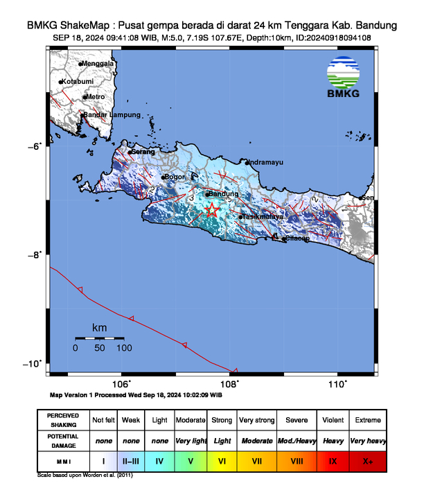