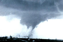
A multiple-vortex tornado is a tornado that contains several vortices (called subvortices or suction vortices) revolving around, inside of, and as part of the main vortex. The only times multiple vortices may be visible are when the tornado is first forming or when condensation and debris are balanced such that subvortices are apparent without being obscured. They can add over 100 mph to the ground-relative wind in a tornado circulation and are responsible for most cases where narrow arcs of extreme destruction lie right next to weak damage within tornado paths.[1]

General
editSuction vortices, also known as suction spots, are substructures found in many tornadoes, though they are not always easily visible. These vortices typically occur at the base of the tornado, where it makes contact with the ground. Sub-vortices tend to form after vortex breakdown reaches the surface, resulting from the interaction of cyclonically incoming and rising air. Although multi-vortex structures are common in tornadoes, they are not unique to them and can occur in other circulations, such as dust devils. This is a natural result of vortex dynamics in physics.Multi-vortex tornadoes should not be confused with cyclically tornadic supercells. Supercells are large, rotating thunderstorms that can produce multiple, distinct tornadoes, often referred to as tornado families. These tornadoes may form at different times or exist simultaneously but are separate from one another.
A phenomenon similar to multiple vortices is the satellite tornado. Unlike the multiple-vortex tornado, where smaller vortices form inside the main tornado, a satellite tornado develops outside the main tornado's circulation. It forms through a different mechanism, typically as a result of interactions with the parent storm's environment. Despite appearing close to the primary tornado, satellite tornadoes are independent and can have their own rotation.[1]
Notable tornadoes
editThe largest tornado ever documented was a multiple-vortex tornado. It struck El Reno, Oklahoma, on May 31, 2013, as a rain-wrapped tornado, taking the lives of tornado researcher Tim Samaras, his son Paul, and their TWISTEX colleague, Carl Young. This storm also took the life of local amateur chaser, Richard Henderson.[2] It had a maximum width of 2.6 miles (4.2 km) and a maximum recorded windspeed of at least 313 miles per hour (504 km/h). However, because of a lack of intense property damage, the tornado achieved a rating of EF3 on the Enhanced Fujita scale.[3] Nevertheless, the El Reno tornado is one of the two strongest tornadoes ever recorded in terms of maximum wind speeds, the other being the 1999 Bridge Creek–Moore tornado which doppler radar measured 321 miles per hour (517 km/h) mph.
The 1997 Jarrell tornado was another example of a multiple-vortex tornado. The infamous “Dead Man Walking” photo of it was at a juvenile stage of sub-vortices development. The 2011 Cullman–Arab tornado is also famous for footage of it "walking" while in it's multi-vortex stage.
See also
editReferences
edit- ^ a b Elite Spotter Workshop crh.noaa.gov Archived 8 August 2010 at the Wayback Machine
- ^ Clay, Nolan (3 June 2013). "Oklahoma storms: Amateur storm chaser took photo of tornado that killed him". The Oklahoman. Archived from the original on 9 March 2016. Retrieved 4 June 2013.
- ^ Jeff Snyder; H. B. Bluestein (2014). "Some Considerations for the Use of High-Resolution Mobile Radar Data in Tornado Intensity Determination". Weather Forecast. 29 (4): 799–827. Bibcode:2014WtFor..29..799S. doi:10.1175/WAF-D-14-00026.1. S2CID 122669043.
External links
edit- Multiple Vortex Tornado at the Online Tornado FAQ