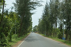
National Highway 116B (NH 116B) starts from Nandakumar, Purba Medinipur district (junction with NH 116) in West Bengal and ends at Chandaneswar, Balasore district in Odisha. The highway is 91 km (57 mi) long. The road passes through Contai and Digha. [1][2][3]
| National Highway 116B | |
|---|---|
Map of the National Highway in red | |
 Contai - Digha highway 2015 | |
| Route information | |
| Length | 91 km (57 mi) |
| Major junctions | |
| From | Nandakumar |
| To | Chandaneswar |
| Location | |
| Country | India |
| States | West Bengal: 91 km (57 mi) |
| Highway system | |
See also
editReferences
edit- ^ [1] Start and end points of National Highways-Source-Government of India
- ^ "New highways notification dated February, 2012" (PDF). The Gazette of India - Ministry of Road Transport and Highways. Retrieved 9 July 2018.
- ^ "State-wise length of National Highways (NH) in India as on 30.06.2017". Ministry of Road Transport and Highways. Retrieved 9 July 2018.
External links
edit- [2] NH network map of India
Wikimedia Commons has media related to National Highway 116B.

