This article needs additional citations for verification. (August 2014) |
Nutbourne is a village in the Chichester District of West Sussex, England located 2 miles (3.2 km) east of Emsworth on the A259 road.[1] It is in the civil parishes of Southbourne and Chidham and Hambrook.
| Nutbourne | |
|---|---|
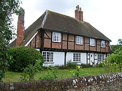
 A 16th century cottage in Nutbourne | |
Location within West Sussex | |
| OS grid reference | SU788054 |
| Civil parish | |
| District | |
| Shire county | |
| Region | |
| Country | England |
| Sovereign state | United Kingdom |
| Post town | Chichester |
| Postcode district | PO18 |
| Police | Sussex |
| Fire | West Sussex |
| Ambulance | South East Coast |
| UK Parliament | |
This small village on the south side of the former A27 road, now the A259, has a loop of road running through it with a ford on the south side of the village centre. It lies at the northern tip of Thorney Channel, an inlet of Chichester Harbour.
See also
editReferences
editExternal links
editMedia related to Nutbourne, Chichester at Wikimedia Commons
