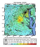
The 2011 Virginia earthquake occurred on August 23, 2011, at 1:51 pm EDT (17:51 UTC) in the Piedmont region of the US state of Virginia. The epicenter, in Louisa County, was 38 mi (61 km) northwest of Richmond and 5 mi (8 km) south-southwest of the town of Mineral. It was an intraplate earthquake with a magnitude of 5.8 and a maximum perceived intensity of VII (very strong) on the Mercalli intensity scale. Several aftershocks, ranging up to 4.5 Mw in magnitude, occurred after the main tremor.
The earthquake, along with a magnitude–5.8 quake on the New York–Ontario border during 1944, is the largest to have occurred in the U.S. east of the Rocky Mountains since an earthquake centered in Giles County in western Virginia occurred during 1897, with an estimated magnitude of 5.8. The quake was felt across more than a dozen U.S. states and in several Canadian provinces, and was felt by more people than any other quake in U.S. history. No deaths and only minor injuries were reported. Minor damage to buildings was widespread and was estimated by one risk-modeling company at $200 million to $300 million, of which about $100 million was insured.
